|
| Routes: State Routes: Interstates US Routes | Home |
| Routes 7-11 (1-6) Prev (12-21) Next |
Quick Links: Marked Unmarked
Decommissioned |
|
Baltimore
Rosedale
White Marsh Bradshaw Harford
Joppa
Van Bibber Abingdon Aberdeen Havre de Grace Cecil
Perryville
Principio Furnace Charlestown North East Elkton |
MD 7
· (Old) Philadelphia Rd.
9 sections
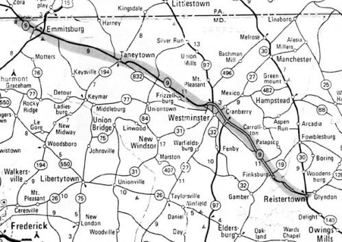
Status: Marked east-west. Created by the construction of Pulaski Hwy., modern US 40, in 1935. MD 7 comprises the old 40. It's in several pieces, as explained below. Associated Secret-Obscure Routes: Sections of MD 7: These
are all signed as part of the 7 mainline. |
7
0.0 US 402.3 MD 588 2.5 I-695 34 2.9 Rossville 6.1 Campbell 6.6 MD 43 11.5 BA-HA Line 13.6 MD 152 16.0 MD 24 18.8 MD 136 19.7 MD 543 22.8 US 40 22.8 MD 159 7A
0.0 US 401.5 MD 490 2.7 US 40 2.7 MD 155 7B
0.0 road end0.5 MD 222 0.8 MD 327 3.6 US 40 7C
0.0 US 401.2 MD 267 2.6 MD 267 4.9 MD 272 7.4 MD 7H 9.7 US 40 9.7 MD 279 7D
0.0 US 400.1 MD 7E 1.6 MD 281 1.7 MD 268 1.9 MD 213 2.6 road end |
|
Queen Anne's
Stevensville
Matapeake Normans Mattapex Romancoke |
MD 8
· Romancoke Rd.
8.37 mi.; from MD 18 across US 50 south to Romancoke
Status: Marked north-south. MD 8 is a relatively new route, in the numbering sense. This stretch has held the numbers 33, 33-404, and finally 8. It is (unless MD 9 is signed tomorrow) the newest and shortest single digit route, individual segments of MD 7 notwithstanding. A ferry once connected Romancoke across Eastern Bay with Claiborne. Both ends were designated Route 33. Another ferry carried traffic across the bay to Annapolis from Matapeake (access road was secret 759), north of which was MD 404. In 1949, US 50 relegated 404 to its current extent. When the Bay Bridge opened in 1952, 33 was connected with 18 just north of the Bay bridge eastern approach. The Romancoke ferry was discontinued, so a new number was required for the northern segment, while 33 remained in Talbot Co. Why 8 was chosen is beyond me. I'll have to make a map to really explain this thing- the first of many, I suppose. Associated Secret/Obscure Routes: |
8
8.4 MD 188.1 US 50-301 37 7.9 MD 835A 5.2 MD 802 4.2 MD 802 0.0 BSM |
|
|
MD 9
Status: Not assigned, but it was apparently almost assigned to current MD 140. A 1979 AAA map (sent to me my Mark Greenwald) showed a MD 9 replacing the decommissioned US 140, suggesting the number was considered by SHA before deciding to keep the 140 number as a state route. According to a newspaper article ("Three Roads Renumbered", The Frederick News, December 5, 1978) SHA originally intended to change the current 140 west of Reisterstown to MD 9, effective January 1, 1979. Reisterstown Road southeast to Baltimore was to be MD 140. This would have made an unusual junction where three routes ended-9, 30, and 140. I am still unsure of when the decision was made to drop MD 9 and use 140 for the whole route, and whether it was ever signed as MD 9. Surely any place with '140' in their name along the entire route would have had to change references to 140 in names, business cards, etc. Thus it would have been a cool reception at best. I wonder how they managed to get 45 and 355 pushed through as new numbers for 111 and 240 when they were decommissioned.
A later ADC Maryland-Delaware atlas once showed in error a MD 9 marker along US 113 in the vicinity of Klej Grange, north of Pocomoke City. It was on their first edition of a computer-generated map and there were many small errors, like wrong state route shield (give them a hand for having correct state marker shapes!). Route 9 disappeared in subsequent editions.
|
|
|
Anne Arundel
Glen Burnie
Harundale Pasadena |
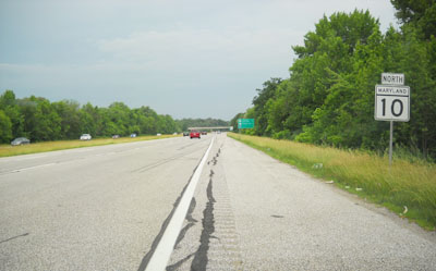
MD 10
· Arundel Expwy.
7.17 mi.; from I-695 Exit 2 south to MD 2, Severna Park
Status: Marked north-south. Limited Access: Entire length, exits not numbered on overhead signs. NHS: Entire length. Associated Secret-Obscure Routes:
|
10
7.2 7 I-695 26.2 6 MD 710 5.0 5 MD 270 3.6 4 MD 648 1.7 3 MD 177 1.3 2 MD 100* 17 0.8 1 MD 100* 18 0.0 MD 2 |
|
Washington
|
US 11
· Potomac St [Williamsport], Virginia Ave, Burhans Blvd, Pennsylvania Ave, Middleburg Pike
12.83 mi.; from WV line near Williamsport north to PA line
at State Line, PA.
Status: Marked north-south. US 11 has its own page in the US highway section. |
|