
|
| Routes: Interstates US Routes State Routes: | Home |
| Routes 540-559 (520-539) Prev (560-579) Next |
Quick Links: Marked Unmarked
Decommissioned |
|
Montgomery
Takoma Park |
MD 540
· was Chestnut Ave.
from MD 320 north to MD 410.
No longer assigned (decommissioned). Just a tiny sliver of 900 feet or so. Where 320 veers left before meeting 410, the old 540 continued straight.
|
|
|
Wicomico
Tyaskin
|
MD 541
· was Tyaskin Rd.
from MD 349 north to road end.
No longer assigned (decommissioned). ...................
|
|
|
Baltimore
Hillendale
Baltimore City
|
MD 542
· Loch Raven Blvd., The Alameda
6.33 mi.; from MD 147 (Harford Rd) north to Cromwell Bridge Rd at I-695 Exit 29.
Marked north-south. Only marked in the city at some intersections, 542 crosses over to Loch Raven Blvd from The Alameda. |
542
6.3 I-695 296.3 Cromwell Bridge Rd 5.9 Joppa Rd 5.5 Putty Hill Rd 4.7 Taylor Ave 4.4 Goucher Blvd 3.7 BC-BA Line 3.3 Northern Pkwy 1.8 Cold Spring La 1.0 The Alameda 1.0 Loch Raven Blvd 0.6 33rd St 0.0 MD 147 |
|
Harford
Pylesville
Ady Hickory Belcamp |
MD 543
· Ady Rd, Fountain Green Rd, Creswell Rd, Riverside Pkwy
19.08 mi.; from US 40 northwest to MD 165.
Marked north-south. ................... |
543
19.1 MD 16516.0 MD 646 15.0 MD 440 10.4 US 1 Bus 10.2 US 1 7.4 MD 22 3.6 MD 136 1.7 I-95 80 1.5 MD 7 0.0 US 40 |
|
Queen Anne's
Kingstown
Crumpton |
MD 544
· McGinnes Rd
9.29 mi.; from MD 213 east to US 301.
Marked east-west. MD 544 runs in a straight line for most of its 9+ miles. There is no direct access across US 301; one has to make a right followed by a U-turn further down. The other section opposite US 301 to MD 313 has been redesignated as MD 544A. At this point I haven't checked the signage status of this section. |
544
0.0 MD 2137.0 MD 290 9.3 US 301 (No access across US 301) |
|
Cecil
Childs
Elkton |
MD 545
· Blue Ball Rd
5.93 mi.; from MD 213, Elkton northwest to end of state maintenance at Warburton Rd/Kirk Rd
Marked north-south. ................... |
545
5.9 ESM0.7 MD 279 0.0 MD 213 |
|
Garrett
Finzel
|
MD 546
· Finzel Rd
3.41 mi.; from I-68 Exit 29 northeast to Pennsylvania border.
Marked north-south. Associated Secret-Obscure Routes: 946 Sections of MD 546: |
546
3.4 PA 20103.4 PA Line 0.6 MD 946 0.2 US 40 Alt 0.0 I-68 29 |
|
Montgomery
Garrett Park
Kensington |
MD 547
· Strathmore Ave, Knowles Ave
1.8 mi.; from MD 355 east to MD 185.
Marked east-west. ................... |
547
0.0 MD 3551.8 MD 185 |
|
Wicomico
Upper Ferry Acres
Allen |
MD 548
· was Upper Ferry Rd
MD 349 south to former MD 529, Allen.
No longer assigned (decommissioned). The ferry across the Wicomico River is still shown on the SHA official maps. |
|
|
Prince George's
Fort Washington
|
MD 549
· was Fort Washington Rd
from Livingston Rd (former MD 224) southwest to road end.
No longer assigned (decommissioned). ................... |
|
|
Washington
Pen Mar
Frederick
Thurmont
Creagerstown Woodsboro Libertytown |
MD 550
· Pen Mar Rd, Macfee Hill Rd, Military Rd, Fort Ritchie Rd,
Sabillasville Rd, Church St, Jimtown Rd, Creagerstown Rd, Woodsboro-Creagerstown Rd,
Woodsboro Rd
24.43 mi.; from MD 26, Libertytown northwest to end of state maintenance in Pen Mar.
Marked north-south. The section northwest of Thurmont was MD 81 prior to 1977. |
550
24.4 ESM23.8 MD 491 14.7 - US 15 14.3 MD 806R 13.9 MD 77 5.6 MD 194A 5.5 MD 194* 5.0 MD 194* 0.0 MD 26 |
|
Dorchester
Cambridge
|
MD 551
· was Washington St
between High St and Race St
No longer assigned (decommissioned), now part of MD 343. MD 551 existed when 343 took High St north through town and 16 ran east from Race St, turning right at Washington. Later, 343 was ran straight through on Washington St, and 16 bypassed the area to the south.
|
|
|
Queen Anne's
Chester
|
MD 552
· Dominion Rd.
2.20 mi.; from US 50-301 "10 mph" ramps south to end of state maintenance at
Little Creek Rd.
Marked north-south. Sections of MD 552: |
552
2.2 US 50-301 39B2.1 MD 18 0.0 Little Creek Rd. |
|
Anne Arundel
Edgewater
|
MD 553
· South River Rd.
3 sections
Marked at northern end. Consists of stubs of old MD 2 bridge crossing over the South River. It dats back at least as far as 1937.
Sections of MD 553: |
553 (b)
0.3 MD 20.1 MD 553C 0.0 BSM |
|
Anne Arundel
Severn
|
MD 554
· was Reece Rd
old number for MD 174 west of MD 170
No longer assigned (decommissioned), entire route now part of MD 174. MD 174 once ran further south, following Quarterfield Rd on its way to MD 170. It was shifted north along Donaldson Ave and Reece Rd, superceding the 554 number.
|
|
|
Calvert
Plum Point
|
MD 555
· was Wilson Rd
from MD 263 south to end of state maintenance.
No longer assigned (decommissioned). ...................
|
|
|
Prince George's
Woodmore
Kolbe's Corner |
MD 556
· was Enterprise Rd, Watkins Park Dr, Oak Grove Rd
from MD 450 south to MD 202
No longer assigned (decommissioned c. 1990), entire route now part of MD 193. In 1985, 193 took over the part of 556 north of 214. Likely by 1990 it had swallowed the rest. ................... |
|
|
Montgomery
Gaithersburg
|
MD 557
· was Brookes Ave
~0.4 mi.; between MD 355 and former MD 114 (N Summit Ave.)
No longer assigned (decommissioned). ................... |
|
|
Charles
Newtown
Bel Alton |
MD 558
· was Bel Alton-Newtown Rd
from US 301 northeast to MD 6.
No longer assigned (decommissioned). ...................
|
|
|
Carroll
Westminster
|
MD 559
· was Gorsuch Rd.
from MD 140 east to WMRR tracks.
No longer assigned (decommissioned).
The original route near 140 has likely been obliterated under big-box store development along neaby parts of the 140 corridor. |
|

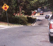 Former MD 540, 1998. MD 320 is off to the left of this photo, and MD 410 is the next intersection
ahead, which comprises 540's entire length.
Former MD 540, 1998. MD 320 is off to the left of this photo, and MD 410 is the next intersection
ahead, which comprises 540's entire length.

 MD 541 shown on a 1958 map.


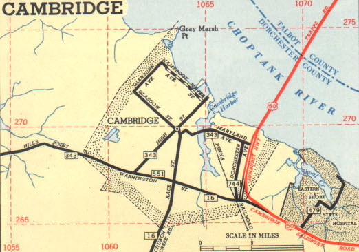 Cambridge inset, showing MD 551, 1953 SRC official map.


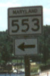 MD 553 marker, 1998.

 MD 554 shown on a 1958 map.

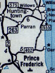 MD 555 shown on a 1958 map.


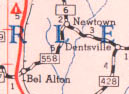 MD 558 shown on a 1955 SRC map.

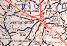 Westminster area routes, including MD 559 (right), shown on a 1955 SRC map.