|
| Routes: Interstates US Routes State Routes: | Home |
| Routes 820-839 (800-819) Prev (840-859) Next |
Quick Links: Marked Unmarked
Decommissioned |
|
Caroline
Goldsboro
|
MD 820
· Castle Hall Rd.
0.13 mi.; east off 313 to road end.
Status: Unmarked, part of old 313. |
|
|
Caroline
Marydel
|
MD 821
· Main St [Marydel]
0.40 mi.; loop south of MD 454 to MD 311.
Status: Unmarked, associated with MD 454. |
|
|
Somerset
Princess Anne
|
MD 822
· UMES Access Road
0.85 mi.; from US 13 east to College Backbone Rd.
Status: Signed east-west. Added in the early 2000s, 822 provides an alternative to Broad St (MD 918) in access to the UMES campus. |
822
0.0 US 130.1 MD 675 0.9 College Backbone Rd |
|
Cecil
Warwick
|
MD 822
· was Joe Meltz Rd
0.65 mi.; from MD 803 (Edgar Price Rd) north to Road End
Status: Status: Decommissioned 1979; transferred to Cecil County maintenance. (SRC Min. 12-27-1979, Agreement 12-26-1979, Effective 12-26-1979) Number reassigned. Unusually long for an unmarked stub. Halfway between US 301 and the Delaware line near the southeastern corner of Cecil County. |
|
|
Cecil
Elkton
|
MD 823
· was Belle Hill Rd.
0.61 mi.; from MD 316 east to MD 279
Status: Decommissioned 1979; transferred to Cecil County maintenance. (SRC Min. 12-27-1979, Agreement 12-26-1979, Effective 12-26-1979) Number no longer assigned, was associated with MD 279. The old alignment of MD 279, before construction of I-95 and a new MD 279 cut it into three segments. It once ran straight from MD 316 to the Delaware border where it became Chestnut Hill Rd. This one appears as 'Former MD 823' on an SHA plat. Thanks to Vince Nohe for catching this one. |
|
|
Cecil
Craigtown
Aikin |
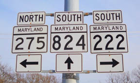
MD 824
· Blythe Dale Rd.
1.06 mi.; loop east of MD 222.
Status: Marked north-south, associated with US/MD 222. MD 824 was part of old US 222 before a new, straighter alignment was constructed for 222's interchange with I-95 in 1963. Not much along it, just an old motel and the I-95 underpass. It allows you to bypass the traffic signals for the I-95 ramps, but not the one for the outlet center, which coincides with MD 824's southern end.
|
824
1.1 MD 2221.1 MD 275 0.0 MD 222 |
|
Cecil
Pilot Town
|
MD 824
· (no name)
0.05 mi.; Road End south of CO 4 (Pilot Town Rd) to Road End N of CO 4.
Status: Decommissioned 1979; transferred to Cecil County maintenance. (SRC Min. 12-27-1979, Agreement 12-26-1979, Effective 12-26-1979) Number reassigned, was associated with western stretch of MD 273. This small stub straddled Pilot Town Road, which used to be part of MD 273, and US 1 prior to 1929, when the old bridge at Bald Friar was demolished to make way for Conowingo Dam. |
|
|
Garrett
Oakland
|
MD 825
· Oakland Dr.
2 sections
Status: Unmarked, associated with MD 135. We now swing all the way to the other end of the state, 825-828 are in Garrett County. Sections of MD 825: |
|
|
Garrett
|
MD 826
14 sections
Status: Unmarked, associated with US 219. Route 826 is given to fragments of the old alignment of US 219. Sections of MD 826: |
|
|
Garrett
Crellin
|
MD 827
2 sections
Status: Unmarked, associated with MD 39. Sections of MD 827: |
|
|
Garrett
|
MD 828
2 sections.
Status: Unmarked, associated with MD 42. Sections of MD 828: |
|
|
|
MD 829
Not assigned. |
|
|
Allegany
Dawson
Rawlings |
MD 830
2 sections off US 220 (McMullen Hwy.)
Status: Unsigned, associated with US 220. Two tiny stubs off US 220. Sections of MD 830: |
|
|
Allegany
Mt. Savage
Barrelville Corriganville Carroll
New Windsor
|
MD 831
9 sections
Status: Unsigned, all except 831J associated with MD 36. MD 831J associated with MD 31. Consists of old alignments of the northern reaches of MD 36. A new section, MD 831J, is an bypassed portion of MD 31, Main Street in New Windsor. MD 831E's name and location are lost to us for the time being. Sections of MD 831: |
|
|
Carroll
Taneytown
Tyrone Frizzellburg |
MD 832
· Old Taneytown Rd
7.67 mi.; from MD 140 at Taneytown circle east to MD 140 near Hughes Shop Rd.
Status: Signed east-west. MD 832 is the original path of MD 32 between Westminster and Taneytown. However, it was never part of US 140, which ran north along current MD 97. MD 97 was used for the new, straighter alignment that would become MD 140. |
832
0.0 MD 1403.1 MD 84 7.7 MD 140 |
|
Carroll
Hampstead
|
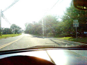
MD 833
· (Old) Black Rock Rd, Gill Ave
0.84 mi.; from Business MD 30 east to MD 88 at circle with Lower Beckleysville Rd (former MD 89).
Status: Signed at east end, associated with MD 88.
With the construction of a circle at MD 88, MD 833 joins the ranks of the signed routes. It was there for quite some time before that, since MD 88 was diverted south a few blocks at its western end at Hanover Pike (MD 30). The other road at the circle, Lower Beckleyville Rd, was once MD 89 from the circle to the Carroll-Baltimore county line, and is not, as some Google Maps show, part of MD 137. If I recall correctly, back around 1992, MD 833 (and thus MD 88 before that) went straight west along what was E Mott Ave (?-also listed as Magna Way on some maps today), connecting with (now Business) MD 30 there. I don't remember any running northwest along the back side of Main Street to hook up with Gill Ave as it is today, and I don't know when it changed over. One thing I remember though for sure, 833 certainly wasn't signed, and that was my first exposure to the concept of the secret or unsigned route. This was the pre-internet era, and I was compiling my first route listing to maybe put online. Using a 286-12 Mhz homebrew PC, with monochrome CRT and 20MB hard drive. The word 'online' would have meant on a friend's BBS back then. How far we've all come. |
833
0.0 MD 30 Bus0.8 MD 88 |
|
Queen Anne's
Hayden
|
MD 834
· Hayden Clark Rd
0.16 mi.; from start at Granny Branch Rd/White Marsh Rd east across US 301 to end of maintenance at MDDE Railroad.
Status: Unmarked. Crosses a wide-median section of US 301, providing access to the Bay Country Rest Stop, which contains a (closed for now) Welcome Center. Be sure to grab some maps on the racks just outside in the lobby. |
|
|
Queen Anne's
Stevensville
Grasonville |
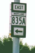
MD 835
10 sections
Status: MD 835A signed, all others unsigned, associated with MD 18.
MD 835 is used for the old alignments of MD 18. These appear alongside the suffixed routes of 18 and 759, in what is called the "land of the 10 mph exits" across Kent Island on US 50-301. The area of commercial development across the island from Stevensville to Grasonville is sometimes, derisively, called "Kent Burnie," referring to the development along MD 2 in Glen Burnie. MD 835A and B were first designated in 1986. 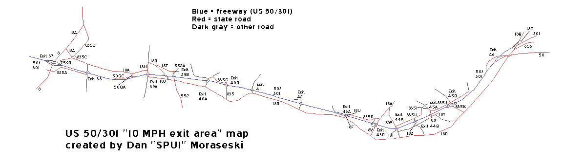 Sections of MD 835: |
835A
0.0 Start0.1 MD 8 0.7 Thompson Creek |
|
Cecil
Rising Sun
|
MD 835
Old Section of US 1, W of Rising Sun
Status: Decommissioned 1959, transferred to Cecil County maintenance. (SRC Min. 05-08-1958, Effective 07-01-1959) number later reassigned. An older verson of 835 from the late 1950s. |
|
|
Queen Anne's
Centreville
|
MD 836
2 sections.
Status: MD 836A Decommissioned 1980; transferred to Queen Anne's County maintenance. (SRC Min. 08-13-1980, Agreement 08-13-1980, Effective 08-11-1980) Status: MD 836B Decommissioned 1962; transferred to Queen Anne's County maintenance. (Agreement 02-19-1962, Effective 02-19-1962) MD 836 was used for two stubs off current MD 213. One was dropped when it was still US 213. Sections of MD 836: |
|
|
Queen Anne's
Sudlersville
|
MD 837
· Church Circle [Sudlersville]
0.12 mi.; from MD 300 northeast to MD 313.
Status: Unsigned. A short northwestern cutoff of the center intersection of Sudlersville, MD 837 was added effective in 1963. |
|
|
Queen Anne's
Wye Island
|
MD 838
· was Wye Island Rd
section near Wye Narrows Bridge
Status: Decommissioned by 1999. |
|
|
Baltimore
Towson |
MD 839
· was Charles Street Ave
1.11 mi.; from Towsontown Blvd north to West Joppa Rd.
Status: Decommissioned 1959; transferred to Baltimore County maintenance. (SRC Min. 08-21-1959, Effective 12-1-1959), number no longer assigned. Charles Street Avenue is the current name for the original Charles Street, for a while called Old Charles Street. Only state route intersection was with MD 141 (Allegany Avenue). West Joppa Road was not part of the state system. |
|