
|
| Routes: State Routes: Interstates US Routes | Home |
| Routes 120-139 (100-119) Prev (140-159) Next |
Quick Links: Marked Unmarked
Decommissioned |
|
Montgomery
Germantown
|
MD 120
· was Aircraft Dr.
0.35 mi.; from MD 118 north to Crystal Rock Dr., Germantown
No longer assigned (decommissioned 1999). MD 120 was east-west Waters Rd. before construction of current I-270 in the early 50s. It was broken in two, a shortened original western section and another further east on 118. The original 120 ran roughly along the path of Father Hurley Blvd. towards what is now I-270 Exit 16. The remaining western segment of Waters was shown as 120 along with the current road in a 1991 SHA grid map. Today, Aircraft Rd. is in sole possession of the 120 designation.
Email from Mark Stein: |
|
|
Montgomery Germantown |
MD 120
· was Waters Rd.
0.35 mi.; from MD 118 north to Crystal Rock Dr., Germantown
No longer assigned (decommissioned 1999). Most of original road no longer exists Waters Rd. was unbroken before construction of current I-270 in the early 50s. Only a small western segment near 118 remains; the rest has been demolished for I-270 and other development. |
|
|
Montgomery
Clarksburg
Boyds |
MD 121
· Boyds-Clarksburg Rd., White Grounds Rd.
9.15 mi.; from MD 28 north to MD 355
Marked north-south. ................... The southern piece of this route was part of a broken 119 as well. Mileage total from the HLR includes the intervening county section between. Update: The southern piece has been decommissioned this year. |
121
9.2 MD 3550.0 MD 28 |
|
Baltimore
Woodlawn
|
MD 122
· Security Blvd.
2.96 mi.; from North Rolling Road east to Baltimore city
line at end of I-70
Marked east-west. Designated a state route around 1990, this six lane divided highway serves the Social Security Administration complex. Security is the final exit for I-70 before its inglorious end at a park and ride at the city line. Looking on the good side, a surface intersection with Ingleside Ave. is the last traffic light between here and Cove Fort, Utah...umm...Breezewood. It becomes unnumbered Cooks Lane to US 40 in Baltimore City, where there are still old "TO I-70N" shields alongside the traffic lights, put there by the city eons ago and forgotten. |
122
0.0 N Rolling Rd.0.6 I-695 17 2.6 Ingleside 2.8 I-70 94 3.0 BA-BC Line 3.0 Cooks La. |
|
Montgomery
Damascus
|
MD 122
· was Bethesda Church Rd.
00.00 mi.; from ... to ...
No longer assigned (decommissioned). ................... |
|
|
Montgomery
Lewisdale
|
MD 123
· was Prices Distillery Rd.
00.00 mi.; from ... to ...
No longer assigned (decommissioned). ................... |
|
|
Montgomery
Damascus
Woodfield Emory Grove Washington Grove Gaithersburg Quince Orchard |
MD 124
· Quince Orchard Rd., Midcounty Hwy., Laytonsville Rd., Burnham Rd., Woodfield Rd.
17.03 mi.; from MD 28 north to MD 108.
Marked north-south. ...................
|
124
17.0 MD 1083.6 MD 355 3.2 I-270 11 3.6 MD 355 2.7 MD 117 0.0 MD 28 |
|
Baltimore
Granite
|
MD 125
· Old Court Rd.
3.53 mi.; from Howard-Baltimore county line at Patapsco River
east to end of state maintenance.
Marked east-west. MD 125 is a 'floating' route; it doesn't touch another route, though it once went further west to MD 99. Old Court Road continues as an unnumbered road northeast to Pikesville, where it becomes MD 133 for a few miles east to Ruxton, near I-83. Route 125 begins Baltimore County's long numbering cluster, starting in the west, then north and southeast through the county, from 125 to 151 except 135-136. |
125
0.0 HO-BA Line3.5 ESM |
|
Baltimore City
Baltimore
Woodlawn
|
MD 126
· was Gwynn Oak Ave.
1.09 mi.; from Baltimore City line southwest to Windsor Mill Rd.
No longer assigned (decommissioned 1999). Adjacent 0.92 mi. stretch of Gwynn Oak in Baltimore City led to MD 26, but not signed by the city. Near the other end at Windsor Mill, the route made an quick left turn from a 2-lane divided to continue on 126 and Gwynn Oak. Heading straight leads to unnumbered Woodlawn Ave. At least it ended up on Windsor Mill about 1000 feet west. |
|
|
Baltimore
Reisterstown
Glyndon |
MD 127
· was Chatsworth Ave.
~0.9 mi; from MD 140 east to Wabash Ave.
No longer assigned (decommissioned). Just a little neighborhood street, number dropped about 1983. |
|
|
Baltimore
Reisterstown
Glyndon Dover Butler |
MD 128
· Butler Rd.
7.62 mi.; from MD 30-795 in Reisterstown east to MD 25, Butler
Marked east-west. ................... |
128
7.6 MD 251.3 Worthington 0.0 MD 795 0.0 MD 30 |
|
Baltimore
Worthington
Stevenson Pikesville Baltimore City
|
MD 129
· Park Heights Ave.
15.43 mi.; from Franklin St. (US 40) in Baltimore City
northwest to Garrison Forest Rd., Worthington
Marked north-south. MD 129 runs northwest from Baltimore, and passes through some of the last open fields inside the Beltway. Contrary to what many computerized maps show, MD 129 does not extend south along Russell St. to I-95, although it would be a logical assumption. The part in question south of US 40 is officially part of MD 295, but there is no signage to this effect. |
129
15.4 Garrison Forest Rd.10.4 MD 130 8.9 I-695 21 8.1 MD 133 7.4 BC-BA Line 5.4 Northern Pkwy. 4.1 Cold Spring La. 2.9 MD 140* 2.7 MD 140* 1.4 US 1 0.0 US 40 |
|
Baltimore
Owings Mills
Stevenson Brooklandville |
MD 130
· Greenspring Valley Rd.
5.57 mi.; from MD 140 east to MD 25, Brooklandville
Marked east-west. Lots of sharp curves, including at least two 90 degree turns. |
130
0.0 MD 1401.7 MD 129 2.7 Stevenson Rd. 4.4 Greenspring Ave. 5.6 MD 25 |
|
Baltimore
Brooklandville
Lutherville |
MD 131
· Seminary Ave.
3.06 mi.; from MD 45 west to MD 25, Lutherville
Marked east-west. ................... |
131
0.0 MD 250.3 Mays Chapel Rd. 2.7 Bellona Ave. 3.1 MD 45 |
|
Harford
Aberdeen
|
MD 132
· Bel Air Ave., Old Post Rd.
3 sections
Marked east-west. ................... Sections of MD 132: |
132
0.0 MD 220.9 MD 462 1.6 US 40 1.9 APG 132 (b)
0.0 MD 221.4 US 40 0.0 MD 000 0.0 MD 000 0.0 MD 000 0.0 MD 000 |
|
Baltimore
Brooklandville
|
MD 132
· was Mays Chapel Rd.
north off MD 131 ~1 mile to Timonium Rd.
No longer assigned (decommissioned 195x). Dropped in the fifties. |
|
|
Baltimore
Pikesville
Ruxton |
MD 133
· Old Court Rd.
3.31 mi.; from MD 129 east to MD 25 & I-83 Exit 12
Marked east-west. This is the the same Old Court Rd. as in 125, but a segment several miles farther east. |
133
0.0 MD 1290.1 Stevenson Rd. 2.0 Greenspring Ave. 3.3 MD 25 3.3 Ruxton |
|
Baltimore
Ruxton
|
MD 134
· Bellona Ave.
1.63 mi.; from MD 139 (Charles St.) north to Ruxton Rd.
Status: Marked north-south. MD 134 once also included Ruxton Rd. from the current northern terminus west to Falls Rd. (MD 25). At that time, the intersection of Ruxton and Falls Rd. was a little bit south of the current intersection, where it is even with Old Court Rd. (MD 133). Another case of staggered intersections getting different numbers. |
134
1.6 Ruxton0.0 MD 139 |
|
Garrett
Oakland
Mountain Lake Park Deer Park Altamont Bloomington Allegany
Piedmont
Luke Westernport McCoole |
MD 135
· Maryland Hwy, Bloomington Rd, Pratt St [Luke], Church St [Westernport], McCoole-Westernport Rd.
29.00 mi.; from US 219 near Oakland east to US 220 near McCoole
Status: Marked east-west.
You'd expect this one to be in northern Baltimore County, but not so, not even close. MD 135 breaks the clustering rules, even though it seems to have been around as long as all the other first-set routes. It's way out west in Allegany and Garrett Counties. I have a theory as to why, though it's only conjecture. Possibly it had been part of MD 41, or possibly 46 for the shortest time early on (1930s or earlier), possibly to concur with WV 46. Another number that would have fit the pattern was 43; I haven't found an original route 43 or 46 yet out there, where they would have belonged. MD 135 between the MD 36 junction in Westernport (across from Piedmont, WV) and MD 135D in Luke connects two segments of WV 46. Topography likely makes linking them entirely on the south bank within West Virginia impossible. Dual-state signage with WV 46 here would facilitate travel. Even MD 46 could be used, since its last incarnation became I-195.Once ran along Swanton and Swanton Hill Rds., parts of which are now MD 495. The portion between Westernport and Luke has to be seen to be believed. An active mill provides steam for the town of Luke which pours out of the gutters, followed by a near-vertical ledge overhanging several hundred feet above. MD 135 certainly warrants further exploration. Associated Secret-Obscure Routes: Sections of MD 135: |
135
0.0 US 2191.5 MD 560 7.4 MD 495 11.1 MD 38 11.1 MD 135C 13.1 Swanton Hill Rd. 21.9 GA-AL Line 21.9 MD 135D 21.9 to WV 46* 23.7 MD 36 23.8 MD 937 23.8 to WV 46* 29.0 US 220 |
|
Harford
Norrisville
Harkins Whiteford Prospect Dublin Churchville Creswell Abingdon |
MD 136
· Calvary Rd, Priestford Rd, Whiteford Rd, Harkins Rd
30.04 mi.; from MD 7, Bush, north and west to MD 23, Norrisville
Status: Marked north-south. Comprised of four roads: Calvary Rd. (MD 7 to MD 22), Priestford Rd. (MD 22 to US 1), Whiteford Rd. (US 1 to MD 624), and Harkins Rd. (MD 624 to MD 23). Makes a broad, semicircular swath through eastern and northern Harford County. Harkins between 23 and 24 was once MD 517. MD 136, at just over 30 miles, may be the longest intra-county state route. Not quite... MD 235 in St. Mary's Co. just beats out 136, 30.63 miles to 30.04. |
136
30.0 MD 2323.8 MD 24 21.6 MD 624 19.2 MD 165 16.2 MD 646 12.8 MD 440 11.8 US 1 6.2 MD 22 2.4 MD 543 0.0 MD 7 |
|
Baltimore
White House
Hereford |
MD 137
· Mt. Carmel Rd.
8.50 mi.; from MD 45 west to Armacost Rd. past MD 25
Marked east-west. ................... |
137
0.0 Gunpowder Rd.1.9 MD 25 7.9 I-83 27 8.5 MD 45 |
|
Baltmore
Hereford
Monkton Shepperd Harford
Blackhorse
|
MD 138
· Monkton Rd., Shepperd Rd., Old York Rd.
9.24 mi.; from MD 45 in Hereford east to MD 23
Marked east-west. There is a 0.4 mile break in state maintenance in unincorporated Monkton. In Hereford, at the western terminus with MD 45, two buildings are close in on either side of 138, making it look like just another street. Many folks miss the turn, especially because 137 (with its very visible intersection and access to I-83) is only 500 feet away on 45. |
138
0.0 MD 453.3 Monkton Rd. 6.1 MD 562 8.3 BA-HA Line 9.2 MD 23 |
|
Baltimore
Ruxton
Towson Lutherville Baltimore City
|
MD 139
· Charles St.
7.88 mi.; from North Ave., US 1 in Baltimore north to
Bellona Ave. near I-695 Exit 25
Marked north-south. The primary north-south street in Baltimore, Charles shares the 139 designation with St. Paul St. in Baltimore City, one way northbound and southbound, respectively. North of Johns Hopkins University, Charles becomes two-way, continuing all the way out to I-695. The northern terminus consists of a roundabout with Bellona Ave. just past I-695. |
139
7.9 Bellona Ave.7.8 I-695 25 5.1 MD 134 4.3 BC-BA Line 3.6 Northern Pkwy. 2.5 Cold Spring La. 2.1 St. Paul St. 1.5 University Pkwy. 1.2 33rd St. 0.9 29th St. 0.8 28th St. 0.0 US 1 |


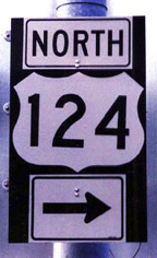 Signage mistake: 'US' 124 just south of MD 115. This sign has since been corrected. (thanks to Mark Stein for photo)


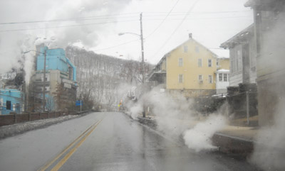 A much different Pratt Street... MD 135 westbound, Luke. (picture 01/24/10)


