
|
|
Home | Interstates | US Routes | MD Routes | Road Pics | About | Links |
| Routes 100-119 (80-99) Prev (120-139) Next |
Quick Links: Marked Unmarked
Decommissioned |
|
Howard
Anne Arundel
|
MD 100
· Paul T. Pitcher Mem. Hwy.
22.05 mi.; from US 29 north of Columbia east to MD 177, Pasadena.
Marked east-west. Limited Access: Between I-95 and MD 607. NHS: From US 29 to MD 2. Originally called the Mountain Road Extension, 100 began as an extension of MD 177 to then MD 3. Later bypassed the bulk of 177 east to an at-grade intersection with MD 607. A small piece of 100 between I-95 and US 1 was also completed in the seventies. It wasn't until the early nineties that construction of MD 100 from the new I-97 west to US 29. The piece between 29 and 104 was upgraded, and the final link opened 11-23-98. Associated Secret-Obscure Routes: |
100
0.0 1a MD 1000.7 1b Long Gate 1.4 1c Center Park 2.5 2 MD 108 2.5 2 MD 104 ?.? 3 Snowden River ?.? 4 MD 103 5.4 5 I-95 43 6.1 6 US 1 6.8 7 Dorsey MARC 7.2 HO-AA Line 7.4 8 Coca-Cola 8.1 9 MD 295 9.1 10 MD 713 11.1 11 MD 170 13.6 13 I-97 14 14.2 14 MD 174 15.6 15 Oakwood 16.8 16 MD 2 17.4 17 MD 10* 18.3 18 MD 10* 19.8 19 Catherine 20.6 20 Edwin Raynor 21.2 MD 607 22.1 MD 177 |
|
Howard
Ellicott City |
MD 100
· was Old Frederick Rd.
from Rogers Ave. east to Patapsco River - Baltimore Co. line.
No longer assigned (decommissioned 1956). |
|
|
Howard
Henryton
|
MD 101
· was Henryton Rd.
from MD 99 north to Patapsco River - Carroll Co. line
No longer assigned (decommissioned 1956). |
|
|
Howard
Ellicott City
|
MD 102
· was Maryland Ave.
from MD 144 south to B&O Railroad Station (~500 feet)
No longer assigned (decommissioned 1956). Has to be seen on an old planning map to be believed. Runs up a steep hillside south of historic district of Ellicott City. |
|
|
Howard
Columbia
Anne Arundel
Dorsey
|
MD 103
· Montgomery Rd., Meadowridge Rd., Dorsey Rd
8.29 mi.; from US 29 southeast to end of SHA maintenance, Dorsey
Marked north-south. Originally ran the entire length of Montgomery Rd. to Elkridge before being diverted onto Meadowridge for its southeastern contact with US 1. Later extended across US 1 along Dorsey Rd, taking over this western part of MD 176, which had been cut off from the remainder by the new MD 100. |
103
8.3 ESM8.1 US 29 23 8.0 Old Columbia Pk. 7.6 Long Gate Pkwy. 6.3 MD 104 5.5 Ilchester Rd. 4.5 Montgomery Rd. 4.1 MD 100 4 2.0 US 1 0.8 AA-HO Line 0.5 Coca-Cola Dr. 0.0 BSM |
|
Howard
Jonestown
|
MD 104
· Waterloo Rd.
1.14 mi.; from MD 108 east to MD 103.
Marked east-west. This section of Waterloo Road was part of MD 175 before construction of Little Patuxent Parkway, MD 175 to US 29 in Columbia. |
104
1.1 MD 1030.1 MD 100 2 0.0 MD 108 |
|
Howard
Ilchester
|
MD 104
· was Ilchester Rd.
east off MD 103 to Patapsco River.
No longer assigned (decommissioned 1956). A bridge over the Patapsco River at the northern end of this route was completed in 1955, this route being decommissioned shortly thereafter. Great timing.... |
|
|
Howard
Ellicott City
|
MD 105
· was Rogers Ave.
current MD 99 east of St. Johns Lane
No longer assigned. Became part of MD 99, that part later decommissioned. |
|
|
Howard
Guilford
|
MD 106
· was Guilford Rd.
Old number for MD 32-732.
No longer assigned, Subsequently became MD 32, and now MD 732. Swallowed up by MD 32 well before 1948. Mentioned in a 1930s operating budget. Marks the end of the original 94-106 Howard County numbering cluster, numbers 107-124 being the domain of Montgomery County except for the lone straggler, 110. |
|
|
Montgomery
Poolesville
Dawsonville |
MD 107
· Fisher Ave [Poolesville], Whites Ferry Rd.
4.79 mi.; from MD 28 west to MD 109 in Poolesville
Marked east-west. The first of the (107-124 exc. 110) series of Montgomery County state routes, 107 once extended further west to Whites Ferry. |
107
0.0 MD 1094.8 MD 28 |
|
Howard
Waterloo
Jonestown Columbia Clarksville Highland Montgomery
Ashton
Sandy Spring Olney Laytonsville Etchison Damascus |
MD 108
34.23 mi.; from MD 27 in Damascus east to MD 175 near I-95 Exit 41
Marked east-west. Now a major thoroughfare in Montgomery and Howard Counties, 108 between Ashton and Columbia traverses the old routing of US 29. Before this adjustment, 108 ended in the 29 junction in Ashton. It was stretched east along 29's old alignment. Southeast of the center of Columbia, 108 swallowed up MD 539 (was the section of 108 between 104 and US 29), then annexing the Waterloo Rd. section of old MD 175 upon completion of Patuxent River Pkwy. (current 175). Too many street names along this route to list now. |
108
0.0 MD 270.2 MD 124 4.4 MD 650 7.4 Sundown Rd. 13.4 MD 97 14.8 MD 182 16.6 MD 650 19.0 MO-HO Line 20.1 MD 216 22.7 MD 32 20 29.2 US 29 21 31.3 MD 104 32.3 Snowden River Pkwy. 34.2 MD 175 |
|
Montgomery
Hyattstown
Comus Barnesville Beallsville Poolesville |
MD 109
· Old Hundred Rd, Beallsville Rd, Elgin Rd [Poolesville]
11.87 mi.; from MD 355 in Hyattstown southwest to MD 107 in Poolesville
Marked north-south. Like 107, once extended beyond Poolesville. |
109
11.9 MD 35511.4 I-270 22 8.5 MD 95 2.4 MD 28 0.0 MD 107 |
|
Frederick
Woodville
|
MD 110
· was Woodville Rd.
northwest of Mt. Airy and MD 144.
No longer assigned (decommissioned 1949). Dissappeared in 1949. Didn't touch any other routes. |
|
|
Maryland Line
Parkton Weisburg Hereford Sparks Hunt Valley Cockeysville Timonium Lutherville Towson Baltimore City
|
US 111
· was York Rd.
00.00 mi.; from ... to ...
Decommissioned 1963, entire original route now MD 45. Decommissioned as a US route in 1963. Entire route now MD 45, later freeway routing is now I-83. See the 111 page in the US routes section for more. |
|
|
Montgomery
Seneca
Darnestown |
MD 112
· Seneca Rd.
2.81 mi.; from MD 190 east to MD 28
Marked east-west. |
112
0.0 MD 1902.8 MD 28 |
|
Worcester
|
US 113
· Worcester Hwy.
37.84 mi. in Maryland; from US 13 in Pocomoke City north
to Delaware line near Selbyville, DE.
Marked north-south. US 113 has its own page in the US highway section. |
|
|
Montgomery
Gaithersburg
|
MD 114
· was Goshen Rd.
00.00 mi.; from ... to ...
No longer assigned (decommissioned). |
|
|
Montgomery
Redland
|
MD 115
· Muncaster Mill Rd.
5.83 mi.; from MD 124 east to MD 28.
Marked east-west. |
115
0.0 MD 1241.0 Shady Grove Rd. 1.0 Airpark Rd. 1.3 Redland Rd. 5.8 MD 28 5.8 MD 655 |
|
Montgomery
Brinklow
Ashton |
MD 116
old number for 650 north of Ashton
before rerouting of US 29 / extension of 650 over old route
No longer assigned, entire route now part of MD 650. US 29 once ran through Ashton, entering on the main south and east streets. MD 116 was the designation for the northern radial and 108 the west. When 29 was moved to the more direct Columbia Pike (MD 196) corridor, 108 was extended over the eastern portion all the way to Columbia, while MD 650 went onto the old 29 north of White Oak, where the old and new split. MD 650 superceded the 116 designation north of Ashton as well, ending at Brighton.
|
|
|
Montgomery
Boyds
Germantown Gaithersburg |
MD 117
· Clopper Rd.
12.67 mi.; from MD 28 east to MD 355.
Marked east-west. |
117
0.0 MD 285.2 MD 121 7.6 MD 118 8.1 MD 119 11.3 MD 124 11.8 I-270 10 12.7 MD 355 |
|
Montgomery
Germantown
|
MD 118
· Germantown Rd.
7.08 mi.; from MD 28 north to MD 355.
Marked north-south. |
118
7.1 MD 3556.2 I-270 15 5.9 MD 120 5.7 Crystal Rock 4.0 MD 117 0.0 MD 28 |
|
Montgomery
Germantown
Gaithersburg |
MD 119
· Great Seneca Hwy.
7.47 mi.; from MD 28 north to
Middlebrook Rd.
Marked north-south. This is a new route added in 1999, in exchange for the dropping
(95, 120, 184, 391, 516, 895, 901, 996) or shortening (121, 188, 191, 787) of
several lesser routes in Montgomery County.
|
119 |
|
Montgomery
Dawsonville
Boyds |
MD 119
· was Schaeffer Rd., White Grounds Rd.
south from MD 117 to MD 28 in 2 pieces near Seneca Creek State Park
No longer assigned (decommissioned), now part of MD 121. Former southern part of this 2-piece route is now the southern piece of a similarly broken MD 121. In both instances, the broken routes are one road, only with breaks in state maintenance. |
|


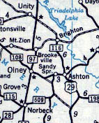 MD 116 near Ashton, from a 1958 Esso General Drafting map.


