
|
| Routes: State Routes: Interstates US Routes | Home |
| Routes 80-99 (60-79) Prev (100-119) Next |
Quick Links: Marked Unmarked
Decommissioned |
|
Frederick
Buckeystown
Urbana Kemptown Montgomery
Clagettsville
|
MD 80
· Fingerboard Rd., Kemptown Rd.
14.78 mi.; from MD 85 east to MD 27.
Marked east-west. ................... |
80
0.0 MD 851.3 MD 880 5.0 I-270 26 5.3 MD 355* 5.5 MD 355* 10.2 MD 75* 10.3 MD 75* 13.4 FR-MO Line 14.8 MD 27 |
|
Washington
|
I-81
· Maryland Veterans Memorial Hwy.
12.08 mi. in Maryland.
Marked north-south. I-81 has its own page in the Interstate section. |
|
|
Washington
Cascade
Pen Mar Frederick
Sabillasville
Lantz Thurmont |
MD 81
· was Sabillasville Rd.
old number for MD 550 north of Thurmont.
No longer assigned (decommissioned 1977); entire route now part of MD 550. Still numbered 81 until 1977, MD 550 was extended through Thurmont onto this portion, which runs north to Blue Ridge Summit and Pen Mar. It was a bit close to I-81, but didn't have an exit on I-70, like MD 68 and I-68 do 18 miles apart. |
|
|
Montgomery
Bethesda
|
MD 82
· was Leland St [Bethesda], Maple Ave.
from MD 191 east to MD 410.
No longer assigned (decommissioned mid 1990s). |
|
|
Baltimore City
Baltimore
|
I-83
· Baltimore-Harrisburg Expwy.,
Jones Falls Expwy.
34.5 mi. in Maryland; from Fayette St. in downtown
Baltimore north to PA line.
Marked north-south. I-83 has its own page in the Interstate section. |
|
|
Carroll
New Windsor
|
MD 83
· was Church St [New Windsor]
one block south of Main St. (MD 31).
No longer assigned (decommissioned). Only reference to MD 83 is in a 30s or 40s SRC operating budget.
|
|
|
Carroll
Uniontown
|
MD 84
· Clear Ridge Rd., Trevanion Rd., Baust Church Rd.
5.75 mi.; from MD 75 north to MD 832
Marked north-south. Route 84 features some tight turns in Uniontown and a few more to the north. Associates Secret-Obscure Routes: |
84
5.8 MD 8323.8 Trevanion 3.1 Uniontown 0.4 MD 800 0.0 MD 75 |
|
Frederick
Frederick
Buckeystown Lime Kiln Tuscarora Licksville |
MD 85
· Buckeystown Rd.
10.63 mi.; from I-70 Exit 35 near Frederick south to MD 28.
Marked north-south. Comprises the north-south part of the old US 15 south of Frederick before being rerouted along part of limited-access US 15-340 in November 1970, the east-west part becoming part of an extended MD 28, from Licksville west to Point of Rocks. A new SPUI interchange with I-70 was completed in 2009, replacing the previous interchange with MD 355. MD 85 now ends at Monocacy Blvd, still under construction, and becomes the extension of East Street (unsigned MD 475) north into Frederick. |
85
10.6 MD 475 10.6 Monocacy Blvd 10.5 I-70 54 10.2 MD 355 9.1 I-270 31 5.4 MD 880 4.6 MD 80 0.0 MD 28 |
|
Carroll
Middleburg
|
MD 85
· was Mt. Union Rd.
small section near Middleburg.
No longer assigned (decommissioned). |
|
|
Carroll
Manchester
Lineboro |
MD 86
· Lineboro Rd, Main St [Lineboro]
4.00 mi.; from MD 30 northeast to PA Line.
Marked north-south. Associated Secret-Obscure Routes: 682 |
86
4.0 PA 5164.0 PA Line 0.0 MD 30 |
|
Carroll
Mexico
Carrollton |
MD 87
· was Leisters Church Rd.
from MD 27 south to Dutrow Rd.
No longer assigned (decommissioned 1956). A 0.4 mi. portion between 482 and 27 is now unsigned MD 849. Before a recent repaving, you could see remains of a narrower concrete slab which ended with the route, where Leister's Church changes names to Dutrow Rd.
|
|
|
Carroll
Hampstead
Baltimore
Armacost
Butler
|
MD 88
· Black Rock Rd, Lower Beckleysville Rd [Hampstead]
8.01 mi.; from Business MD 30 in Hampstead east to MD 25 near Butler.
Marked east-west. MD 88 is a useful route for getting around the congestion of MD 30/140 and I-795. It dumps you into MD 25 (Falls Rd), the only drawback comes if you have to get to I-83. In that case. Lower Beckleysville Rd (former MD 89) gives access to MD 137 which connects direcly to I-83. Associated Secret-Obscure Routes:
|
88
0.0 MD 30 Bus0.7 MD 833 1.1 CR-BA Line 8.0 MD 25 |
|
Carroll
Hampstead
|
MD 89
· was Lower Beckleysville Rd.
from MD 88 northeast to Carroll-Baltimore county line.
No longer assigned (decommissioned 1956). In a classic piece of Maryland route strangeness, MD 89 ended at the Carroll/Batlimore county line. Lower Beckleysville continued east to MD 25, in the process MD 137 ended here. The intersection with MD 88 is now a circle, and this road is marked "TO MD 137". Google Maps currently has this incorrectly depicted as being part of 137. Great idea, but it hasn't happened yet. If it's so important, either extend 137 west, or bring back 89, but for all of Lower Beckleysville east to MD 25. Of course, Baltimore County would have to give up lane-miles in more central areas to achieve this. |
|
|
Worcester
Berlin
Ocean Pines Ocean City |
MD 90
· Ocean City Expwy.
11.83 mi.; from US 50 east to MD 528.
Marked east-west. NHS: Entire length Completed in 1971 as an alternative to US 50, MD 90 offers a second bridge across the Isle of Wight and Assawoman Bays into Ocean City. Hits MD 528 at 62nd Street. Although an 'expressway', 90 has one at-grade intersection with a traffic light. This is at St. Martin's Neck Rd., where the round trip without this junction amounts to 15 miles. A 2-lane partially divided, controlled access highway, 90 is one of the more dangerous roads in Maryland. Its straightness can lull you into a false sense of confidence, and the approaching scenery of Ocean City can distract you. Add a beach traffic backup ahead just beyond the limited sight distance, and conditions are ripe for frequent accidents. Center dividers are being installed to prevent head-on collisions, and signs warning about possible sudden traffic backups have been added. Daytime headlights are required, as on the adjacent 2-lane parts of US 113. |
90
0.0 - US 504.4 - US 113 6.0 - MD 589 9.5 St. Martins Neck 11.8 MD 528 |
|
Carroll
Hampstead
Carrollton |
MD 90
· was Houcksville Rd.
southwest off MD 30 to indeterminate point.
No longer assigned (decommissioned 1956). Now opposite the new alignment of MD 88. The endpoint of the old route, from my best guess on old maps, was near St Pauls Rd. See the map under MD 87 above for an idea of the layout here.
|
|
|
Baltimore
Fowblesburg
Carroll
Finksburg
Gamber |
MD 91
· Emory Rd., Gamber Rd.
7.86 mi.; from MD 32, Gamber northeast to MD 30, Fowblesburg.
Marked north-south. Associated Secret-Obscure Routes: |
91
7.9 MD 306.4 CR-BA Line 3.7 MD 879 3.2 MD 140 2.9 MD 879 2.2 MD 879 1.7 MD 879 1.5 Deer Park 0.0 MD 32 |
|
Washington
Smithsburg
|
MD 92
· was Rowe Rd.
from MD 64 northeast of Smithsburg to indeterminate point.
No longer assigned (decommissioned). |
|
|
Carroll
Eldersburg
|
MD 93
· was Oakland Rd.
from MD 26 north to Carroll-Baltimore county line.
No longer assigned (decommissioned 1954). Dropped in mid-fifties when Liberty Reservoir took out its bridge over the Patapsco River. It marks the end of Carroll County's initial 83-93 numbering cluster. Howard County is home to 94-106.
|
|
|
Howard
Lisbon
|
MD 94
· Ellicott Rd., Florence Rd.
6.25 mi; from Old Frederick Rd. south to
Montgomery-Howard Co. line
Marked north-south. |
94
6.3 Old Frederick5.9 I-70 73 5.3 MD 144 0.0 MO-HO Line |
|
Prince George's Howard
Baltimore
Baltimore City
Baltimore
Harford
Cecil
|
I-95
109.05 mi. in Maryland; from Woodrow Wilson Bridge north
to DE line near Elkton.
Marked north-south. I-95 has its own page in the Interstate section. |
|
|
Montgomery
Comus
|
MD 95
· was Comus Rd.
0.85 mi.; from MD 109 northwest to end of state maintenance.
Decommissioned 1999, transferred to Montgomery County maintenance. A case of MD-Interstate duplication, MD 95 was dropped in Montgomery County's Great Decommission of 1999, along with fellow duplicate MD 895 at the other end of the county. |
95
0.8 ESM0.0 MD 109 |
|
Howard
Daisy
|
MD 96
· was Daisy Rd.
from MD 144 south to Union Chapel Rd.
No longer assigned (decommissioned 1956). |
|
|
Anne Arundel |
I-97
16.99 mi. in Maryland; from US 50-301 north to I-695
Marked north-south. I-97 has its own page in the Interstate section. |
|
|
Carroll
Silver Run
Union Mills Mt. Pleasant Westminster Fenby Howard
Cooksville
Glenwood Montgomery
Sunshine
Brookeville Olney Norbeck Aspen Hill Wheaton Silver Spring |
MD 97
· Georgia Ave, High St [Brookeville], Market St [Brookeville], Roxbury Mills Rd, Hoods Mill Rd, Old Washington Rd, New Washington Rd, Malcolm Dr [Westminster], Baltimore Blvd [Westminster], Littlestown Pike
55.27 mi.; from US 29/MD 384 in Silver Spring north to PA line.
Marked north-south. Once ended short of Howard-Carroll county line., later taking over alignment of old MD 570 to Westminster. MD 97 traversed the current MD 140 west through Taneytown to Emmitsburg before US 140 was decommissioned in 1979. At that time 140 and 97 swapped alignments, making both routes straighter. Named Georgia Ave throughout Montgomery Co, Roxbury Mills/Hoods Mill Rd in Howard Co, Old/New Washington Rd south of Westminster, Malcolm Dr in Westminster near the eastern split with 140, Baltimore Blvd along the 97-140 concurrency, and Littlestown Pike from the western 140 split north to the PA border. Much further south, and in another world completely from Carroll and western Howard, in Montgomery County (down in Silver Spring) the route for a brief time ended at MD 390, as if it may have planned to be shifted onto the latter. There was once an 'End State Maintenance' sign at this point. However, that section has since been restored to state maintenance, with signage confirmed by multiple readers. Associated Secret-Obscure Routes: |
97
55.3 PA 9755.3 PA Line 47.3 MD 496 44.9 MD 140* 43.9 MD 27 42.6 MD 140* 39.4 MD 32 32.7 MD 26 26.9 HO-CR Line 25.0 I-70 76 25.0 US 40 76 24.6 MD 144 18.2 MO-HO Line 17.0 MD 650 11.9 MD 108 ?.? MD 200 9 8.8 MD 28 6.1 MD 185 4.8 MD 182 3.5 MD 193 3.1 MD 586 1.6 MD 192 1.4 I-495 31 1.1 MD 391 0.9 MD 390 0.0 MD 384 0.0 US 29 |
|
Howard
Glenelg
|
MD 98
· was Folly Quarter Rd.
from MD 144 southwest to MD 32.
No longer assigned (decommissioned 1956). |
|
|
Howard
Mt. Hebron
Ellicott City |
MD 99
· Old Frederick Rd., Rogers Ave.
7.57 mi.; from MD 32 east to US 29.
Marked east-west. One traversed St. Johns Lane to MD 144 over parts of old routes 100 and 105 along Rogers Ave. to Ellicott City, where 10x state routes once swarmed. Now ends together with northern end of US 29. Associated Secret-Obscure Routes: |
99
0.0 MD 327.6 US 29 |


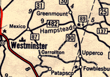 MD 87, 89 & 90 in eastern Carroll County shown on 1954 Esso map. Red line was US 140
(now MD 140 & MD 97). Route 31
shown on the map is now 27. MD 87 ended near where it hits the 's' in
'Westminster'. MD 89 ended at the county line, consisting only of the section
pointed to on the map. The road southeast of Hampstead
is MD 88; the marker is cropped off the right edge of the map. As can be seen here,
taking 90 didn't get you to O.C. back then. :) It ended at an indeterminate
point between the 90 marker and the lettering for 'Carrollton' on the map.
MD 87, 89 & 90 in eastern Carroll County shown on 1954 Esso map. Red line was US 140
(now MD 140 & MD 97). Route 31
shown on the map is now 27. MD 87 ended near where it hits the 's' in
'Westminster'. MD 89 ended at the county line, consisting only of the section
pointed to on the map. The road southeast of Hampstead
is MD 88; the marker is cropped off the right edge of the map. As can be seen here,
taking 90 didn't get you to O.C. back then. :) It ended at an indeterminate
point between the 90 marker and the lettering for 'Carrollton' on the map.
 At MD 30, the western end of MD 88. Note the "TO 137" marker alongside.

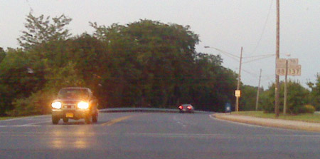
 Scenes like this make all these roadtrips worthwhile. Taken 07/12/09 from former MD 90.


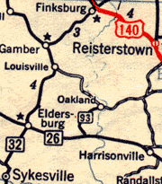 MD 93 shown on a 1954 Esso General Drafting map. The
river running north-south is the Patapsco River's northern branch, forming the
Carroll-Baltimore county line. A dam was later built, creating Liberty Reservoir,
eliminating the 93 bridge across the river at Oakland. MD 93 was soon scrapped.
MD 93 shown on a 1954 Esso General Drafting map. The
river running north-south is the Patapsco River's northern branch, forming the
Carroll-Baltimore county line. A dam was later built, creating Liberty Reservoir,
eliminating the 93 bridge across the river at Oakland. MD 93 was soon scrapped.


