
|
| Routes: State Routes: Interstates US Routes | Home |
| Routes 60-79 (40-59) Prev (80-99) Next |
Quick Links: Marked Unmarked
Decommissioned |
|
Washington
Hagerstown
Leitersburg |
MD 60
· Leitersburg Pike
7.27 mi.; from Northern Ave., Eastern Blvd. northeast to PA line
near Rocky Forge
Marked north-south. According to SHA maps, state maintenance ends near the Hagerstown city line. Becomes North Potomac St. in Hagerstown. Across US 40, it becomes South Potomac St., and MD 65. Associated Secret-Obscure Routes: Suffixed section of MD 60: |
60
7.3 PA 3167.3 PA Line 5.3 MD 418 4.8 MD 62 0.0 Northern/Eastern |
|
Allegany
Cumberland
|
MD 61
· Canal Pkwy
1.94 mi.; from WV line at Potomac River north to MD 51
Status: Unmarked. A new route in 2001, offering a new Potomac River crossing into West Virginia. It links MD 51 east of Cumberland to WV 28 and the Cumberland municipal airport which is on the West Virginia side of the river. It's only 2 lanes, wedged in tightly between the massively wide rail yard and the Potomac River. South of West Elder Street, it's divided, but only one lane each way. No trucks over 5 tons are permitted. Brown signage is used and brick on walls and bridge abutments. Suffixed sections of MD 61: |
61
1.9 MD 51 (W/B)1.7 MD 51 (E/B) 0.4 River Ave. 0.0 WV Line 0.0 WV 28 |
|
Washington
Hagerstown
|
MD 61
· was Old Forge Rd.
1.08 mi.; between Antietam Rd. and Herman Myers Rd. east of Hagerstown
Decommissioned 1956 (SRC Min. 10-15-1953, Effective 07-01-1956), number reassigned 2001. |
|
|
Washington
Leitersburg
Chewsville |
MD 62
· Little Antietam Rd.
3.88 mi.; from MD 804B in Chewsville north to MD 60 near Leitersburg
Marked north-south. Does not technically reach MD 64, but the 'old' 64, now assigned unmarked MD 804B. |
62
3.9 MD 600.0 MD 804B |
|
Washington
Cearfoss
Huyett Williamsport Fairplay Tilghmanton |
MD 63
· Spielman Rd., Greencastle Pike
16.99 mi.; from MD 65 in Tilghmanton north to PA line
north of Cearfoss
Marked north-south. Associated Secret-Obscure Routes: North of Williamsport, this route was MD 398, because of the old 'no duplex' policy; 63 and 68 share a 2-mile section. |
63
17.0 PA Line15.4 MD 58 15.4 MD 494 11.8 US 40 10.2 I-70 24 8.0 US 11* 7.9 US 11* 7.9 MD 68* 6.7 MD 68* 3.9 MD 632 0.0 MD 65 |
|
Washington
Hagerstown
Chewsville Cavetown Smithsburg Ringgold |
MD 64
· Cleveland Ave [Hagerstown], Jefferson Blvd, Smithsburg Pike
13.33 mi.; from US 40 in Hagerstown east to PA line north of Ringgold
Marked east-west. Associated Secret-Obscure Routes: |
64
13.3 PA 99713.3 PA Line 12.4 MD 418 9.9 MD 66 8.5 MD 491 7.8 MD 844 4.3 MD 804 (62) 0.0 US 40 |
|
Washington
Hagerstown
Halfway Lappans Tilghmanton Sharpsburg |
MD 65
· Sharpsburg Pike
11.75 mi.; from Hagerstown city line south to MD 34,
Sharpsburg
Marked north-south. Near its southern end in Sharpsburg, Route 65 passes near Antietam National Battlefield. |
65
11.8 ESM10.6 I-70 29 6.8 MD 68 5.7 MD 63 0.0 MD 34 |
|
Washington
Boonsboro
Wagners Crossroads Beaver Creek Cavetown Smithsburg |
MD 66
· Mapleville Rd., Bradbury Ave.
12.84 mi.; from Alt US 40, Boonsboro north to MD 64 north
of Smithsburg.
Marked north-south. |
66
12.8 MD 6410.3 MD 64 5.3 I-70 35 4.3 US 40 0.0 US 40 Alt |
|
Washington
Boonsboro
Rohrersville Gapland Brownsville Weverton |
MD 67
· Rohrersville Rd.
12.20 mi.; from Alt. US 40 south to US 340 Exit 1, Weverton
Marked north-south. Associated Secret-Obscure Routes: Sections of MD 67: |
67
12.2 US 3400.0 US 340 1 |
|
Garrett Allegany Washington |
I-68
81.09 mi. in Maryland; from WV line east to I-70, Hancock.
Marked north-south. |
|
|
Washington
Clear Spring
Pinesburg Williamspost St. James Lappans |
MD 68
· Lappans Rd., Clear Spring Rd.
18.50 mi.; from US 40, Clear Spring east to Alt. US 40
north of Boonsboro
Marked east-west. I-68 has its own page in the Interstate section. |
68
0.0 US 400.5 I-70 18 2.7 MD 56 7.3 US 11 7.3 MD 63 8.3 I-81 1 8.5 MD 63 10.5 MD 632 13.4 MD 65 18.5 US 40 Alt |
|
Frederick
Braddock Heights
|
MD 69
· was Jefferson Blvd.
from Alt. US 40 south to Cherry Lane.
No longer assigned (decommissioned 1956). Gone by 1961. Had nothing to do with sign theft, more like the Twelve Year Program. Theft of Route 69 markers in other states such as New Jersey, which changed its Route 69 to 31 to save money on replacement, was discussed in a recent misc.transport.road thread. Also mentioned was theft of route markers depicting other suspect numbers, such as various states' 420, and the infamous US 666 in Arizona and New Mexico. FYI, MD 69 was dropped before 1961, MD 420 was gone by the seventies, and MD 666 (ironically, Saint Paul St. in Kensington) was probably never signed, but also gone by the fifties. |
|
|
Washington
Frederick
Carroll
Howard
Baltimore
|
I-70
93.62 mi.; from PA line in Hancock east to Security Blvd.
(MD 122) at Baltimore city line
Marked north-south. I-70 has its own page in the Interstate section. |
|
|
Anne Arundel
Annapolis
|
MD 70
· Roscoe Rowe Blvd.
2.32 mi.; from Bestgate Rd. south to MD 450.
Offers best entrance to Annapolis, on axis with the State
Capitol. The State Archives are at the first left after MD 435; spent many a
Saturday there researching for this site. It's well out of the way of I-70, so
peaceful coexistence without confusion is possible. Interstate numbers don't seem to be a consideration
when using or changing Maryland route numbers as is the case in other states. Marked north-south. |
70
2.3 Bestgate1.6 US 50-301 24 0.8 MD 435 0.3 BSM 0.0 MD 450 |
|
Frederick
Brunswick
Knoxville |
MD 70
· was Knoxville Rd.
old number for current MD 478
No longer assigned, route is now MD 478. The 70 number was already switched to 478 to make way for Rowe Blvd sometime between 1949 and 1953, too early for the change to be for I-70; the Interstate Highway legislation wasn't passed till 1956. |
|
|
Queen Anne's
Kent
|
MD 71
old number for Eastern Shore US 301
No longer assigned, changed to part of US 301 circa 1960. Current US 301 on the Eastern Shore opened as MD 71 on December 3, 1956. Number removed when US 301 rerouted into Delaware on this highway; 71 is the only 2 digit number to be scrapped twice! However, both former 71s are not only still numbered highways, but main drags. Choice of 71 may have been an attempt to match numbers with nearby Delaware 71 or vice-versa.
|
|
|
Frederick
Woodsboro
Carroll
Taneytown
|
MD 71
· was Francis Scott Key Hwy., Woodsboro Pike
old number for current MD 194
No longer assigned (decommissioned c. 1958), now MD 194. Entire route now MD 194. Number 71 later given to Blue Star Mem. Hwy., now the Eastern Shore part of US 301. |
|
|
Frederick
Lewistown
Creagerstown |
MD 72
· was Lewis Station Rd.
from US 15 near Lewistown northeast to MD 550 south of
Creagerstown
No longer assigned (decommissioned 1956). |
|
|
Frederick
Frederick
|
MD 73
· was Yellow Springs Rd.
from US 15 northwest to ...
No longer assigned (decommissioned c. 1967). A northern portion of this route survived into 1966, but gone by '68.
|
|
|
Frederick
Frederick
|
MD 74
· was Oppossumtown Pike
from US 15 north to end of state maintenance.
No longer assigned (decommissioned 1956). Gone by 1961, possibly engulfed by annexation of entire route by Frederick. May also explain northern part of 73 sticking around another five years. The formerly state maintained portion has been made into a 4 lane divided suburban access road. There's no way of telling that it ever was anything other than a new road to get to new subdivisions wedged in on the edge of Fort Detrick. |
|
|
Carroll
New Windsor
Linwood Union Bridge Frederick
Johnsville
Libertytown New London New Market Green Valley |
MD 75
· Green Valley Rd.
28.53 mi.; from MD 355 near Frederick-Montgomery Co. line
north to MD 31 in New Windsor
Marked north-south. In the Carroll County portion, from Union Bridge to the 'northern' terminus' in New Windsor, northbound traffic actually heads east-southeast! Associated Secret-Obscure Routes: |
75
28.5 MD 3127.3 MD 800 27.7 MD 84 27.1 MD 800 25.7 MD 800 23.1 FR-CR Line 15.6 MD 26 8.8 MD 874 8.4 MD 144 8.1 I-70 62 8.1 US 40 62 7.8 MD 877 5.0 MD 80* 4.8 MD 80* 0.0 MD 355 |
|
Frederick
Motters
Rocky Ridge |
MD 76
· Motters Station Rd.
5.69 mi; from US 15 near Mt. St. Mary's College south to
MD 77, Rocky Ridge
Marked north-south. |
76
5.7 US 150.0 MD 77 |
|
Washington
Smithsburg
Frederick
Thurmont Graceham Rocky Ridge Carroll
Detour Keymar |
MD 77
· Rocky Ridge Rd.
20.74 mi.; from MD 64 near Smithsburg east to MD 194, Keymar
Marked east-west. MD 77 passes through Catoctin Mountain Park, and runs near to the presidential retreat, Camp David. |
77
0.0 MD 643.0 WA-FR Line 10.1 US 15 10.5 MD 550* 11.5 MD 550* 16.0 MD 76 18.8 FR-CR Line 20.7 MD 194 |
|
Frederick
Frederick
Church Hill |
MD 78
· was Ballenger Creek Pike
old number for current MD 351
No longer assigned (became part of MD 180 in early 70s, and MD 351 since 1988). MD 78 comprised all of what is now Route 351, with exception of some changes in alignment at the northern end with I-70 and US-340. It still ends in the same indeterminate place just short of Church Hill as 351 now as it did then as 78. Has been part of U-shaped 180 and now 351 since dropping of 78. Through these number changes, the route itself is mostly unchanged. |
|
|
Frederick
Brunswick
Rosemont Petersville |
MD 79
· Petersville Rd.
1.81 mi.; from MD 17, Brunswick north to MD 180,
Petersville.
Marked east-west. Awfully short for a 2-digit route. Associated Secret-Obscure Routes: |
79
1.8 MD 1800.0 MD 17 |


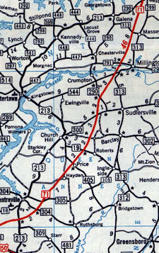 MD 71 on the Upper Eastern Shore, 1958.


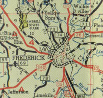 MD 73, 74, 59, 69, 71, 78 around Frederick, 1955. MD 71 became 194, 78 became 180, then 351. The rest were gone by 1970.


