|
| Routes: State Routes: Interstates US Routes | Home |
| Routes 40-59 (22-39) Prev (60-79) Next |
Quick Links: Marked Unmarked
Decommissioned |
|
Garrett
Allegany
Washington
Frederick
Carroll
Howard
Baltimore
Baltimore City
Baltimore
Harford
Cecil
|
US 40
231.39 mi. in Maryland; from PA line at Oakton east to Delaware
line near Elkton.
Marked east-west. US 40 has its own page in the US highway section. |
|
|
Baltimore
Perring
Hillendale |
MD 41
· Perring Pkwy.
2.97 mi.; from Baltimore city line north to Waltham Woods Rd.
Marked north-south. MD 41 serves as an at-grade partial limited access route, cutting through the area between Towson and Parkville. It was completed in the mid-late sixties as a connector to I-695. It was to have been part of a larger project called the Perring Freeway, running north to Bel Air as a possible replacement of US 1, but was killed in the indeterminate past. I don't recall Perring being designated as Route 41 until about 1988 or so; the markers on some overhead signs of I-695 appear to have been an afterthought. It's supposed to go into Baltimore City, but it's not posted, and so I have it ending at the city line. |
41
3.0 Waltham Woods2.5 Joppa 2.3 I-695 30 1.7 Putty Hill 1.0 Taylor 0.6 Oakleigh 0.1 McClean 0.1 Hillsway 0.0 BC-BA Line |
|
Garrett
Oakland
Deer Park |
MD 41
· was Oakland-Westernport Rd..
old number for MD 135 between Oakland and Deer Park.
No longer assigned (now part of MD 135). |
|
|
Garrett
Asher Glade
Friendsville Elder Hoyes |
MD 42
· Friendsville Rd.
15.06 mi.; from US 219 near McHenry north to PA line near Asher Glade.
Marked north-south. Route 42 used to run east of Friendsville to US 219 north of Accident, but was shifted south to its current location in late 1959. Associated Secret-Obscure Routes: 742 828 Section of MD 42: |
42
15.1 PA 201315.1 PA Line 9.2 MD 42A 8.4 MD 828 7.8 MD 742 7.7 I-68 4 7.3 MD 742 0.0 US 219 |
|
Baltimore
Putty Hill
Fullerton White Marsh Middle River |
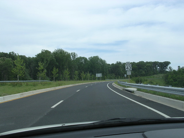
MD 43
· White Marsh Blvd.
8.64 mi.; from I-695 Exit 31C east to MD 150
Marked east-west. The first part of Route 43 was built in 1963 along with the first part of the JFK Memorial Highway (I-95), between the new interstate and the parallel Pulaski Highway (US 40). It marked the southern end of the toll portion of that highway. The westward extension, in original freeway plans, was completed as a partial limited access with at-grade intersections by 1994. Route 43 was always posted on overhead signs on I-95 and US 40, but reassurance markers on 43 itself did not appear until the entire route was completed. Construction began in 2003 on the extension of Route 43 south to Route 150, Eastern Blvd. The first portion, from US 40 south to a new industrial park, was completed late in 2005 with the entire route completed and opened October 23, 2006. The alternative that is the final alignment is referred to in the planning docs as "D modified".
|
43
0.0 I-695 31c0.6 Walther 1.1 US 1 3.0 Perry Hall 3.6 Honeygo 4.2 I-95 67 4.7 MD 7 5.5 US 40 8.6 MD 150 |
|
Washington
Big Pool
|
MD 44
· was Fort Frederick Rd.
south off MD 56 near I-70 Exit 12.
No longer assigned (decommissioned sometime between 1966 and 1970). The entrance to Fort Frederick State Park. Though gone for a while on official maps, the ADC books still show it.
|
|
|
Baltimore
Maryland Line
Parkton Weisburg Hereford Sparks Hunt Valley Cockeysville Timonium Lutherville Towson Baltimore City
|
MD 45
· York Rd. Greenmount Ave
30.02 mi.; from North Ave. (US 1) in Baltimore north to PA line, Maryland Line.
Marked north-south. The pre-freeway route of US 111 before it was diverted onto the current I-83 during the fifties and later totally decommisioned in 1963. Route 45 was posted on the bypassed sections piece by piece. The part south of the I-695 beltway was US 111 until the end, and 45 only fully replaced 111 in 1963. York Rd becomes Greenmount Ave at what appears to be an indeterminate point around 43rd St in North Baltimore. This is a remnant of the old 1888 Baltimore city limits. Until 1888, the northern limit of Baltimore City was North Avenue; the city reached its current size and shape, roughly similar to the state of Nevada, in 1918. The annexed stretch of York Rd retained its name thereafter. Associated Secret-Obscure Routes: |
45
30.2 PA 300130.2 PA Line 24.7 Freeland 28.8 MD 439 25.3 I-83 33 24.3 MD 463b 24.0 MD 463a 23.0 Middletown 20.4 MD 137 20.3 MD 138 16.9 Belfast 13.4 Shawan 13.1 MD 145 11.9 Warren 10.5 Padonia 9.4 Timonium 7.8 MD 131 7.3 I-695 26 6.8 MD 45 Byp. 6.4 (circle) 6.4 Allegany/Joppa 6.4 MD 146 6.1 Towsontown 5.9 MD 45 Byp 4.2 BC-BA Line 3.7 Northern 2.4 Cold Spring 1.2 33rd St. 0.0 US 1 |
|
Baltimore
Towson
|
MD 45 Bypass
· Bosley Ave.
00.00 mi.; Towson Bypass
Marked north-south by Baltimore County. Marker is green as it appears to left. This particular one was replaced in Sept. 2002 with regular white markers as new traffic lights were installed on York Rd. Some green markers may remain on Bosley Rd itself.
|
45 Byp.
0.0 MD 450.0 Joppa 0.0 Allegany 0.0 Towsontown 0.0 MD 45 |
|
Allegany
Frostburg
|
MD 45
· was Water St.
west off Alt. US 40 northwest of Frostburg.
No longer assigned (decommissioned 1950s) |
|
|
Anne Arundel
BWI Airport
|
MD 46
· was BWI Access Rd.
now I-195
No longer assigned, entire route now I-195. MD 46 was the number for the old BWI cutoff when the only access was via the B-W Parkway. Upon completion of I-195 in 1990 MD 46 was dropped. |
|
|
Allegany
Barrelville
|
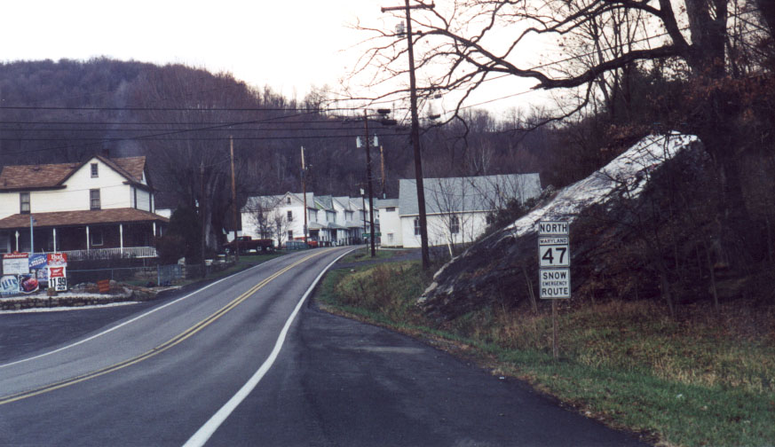
MD 47
· Barrelville Rd.
1.70 mi.; from MD 36 in Barrelville north to PA line.
Marked north-south. A quick dash for the Pennsylvania border. Becomes PA 160 on the other side.
|
47
1.7 PA 1601.7 PA Line 0.0 MD 36 |
|
Garrett
Allegany
Washington
|
US 48
· was National Freeway
00.00 mi. in Maryland; from ... to ...
No longer assigned (decommissioned), entire route now I-68. US 48 has its own page in the US highway section. |
|
|
Allegany
Cumberland
|
MD 48
· was Pineridge Rd.
small sliver from US 220 north to PA line
No longer assigned (decommissioned 1950s). A tiny sliver of a road wedges between US 220 and the PA border.
|
|
|
Allegany
Cumberland
|
MD 49
· Braddock Rd.
1.02 mi.; from Vocke Rd. (MD 658) east to Cumberland
town limits.
Marked east-west. MD 49 has had its western end cut up and overlaid by I-68. It now ends at MD 658, Vocke Road. Though SHA maintenance and the route log show it as ending at Cumberland's western limits, it remains signed in town west of Fayette St (former alignment of US 220). Associated Secret-Obscure Routes: |
49
0.0 MD 6580.0 MD 40 1.0 Cumberland line |
|
Garrett
Prince George's
Anne Arundel
Queen Anne's
Talbot
Dorchester
Wicomico
Worcester
|
US 50
00.00 mi.; from ... to ...
Marked east-west. US 50 has its own page in the US highway section. |
|
|
Allegany
Cumberland
North Branch Spring Gap Oldtown |
MD 51
· Industrial Blvd., Uhl Hwy.
25.53 mi; from I-68 Exit 43B east to Potomac River-WV line.
Marked north-south. George Clinton Uhl was an SRC commissioner in the 1920s, thus the name. Route 51 is marked north-south although most of its run is east-west along the Potomac. Doesn't touch another state route besides its own alternate during its entire 25 mile run. There is an unnumbered road on SHA maps which looks like a tempting shortcut from MD 51 to I-68 eastbound...it's a dirt road through Green Ridge State Forest, about 10 miles long. Sections of MD 51: |
51
0.0 I-68 43b3.5 MD 51e 5.6 MD 51e 25.5 WV Line 25.5 WV 9 |
|
Allegany
Cumberland
|
MD 52
· was Williams St.
from Cumberland town limits east to near Christie Rd.
No longer assigned (decommissioned 1950s). |
|
|
Allegany
LaVale
Cresaptown |
MD 53
· Winchester Rd.
3.33 mi; from from Alt. US 40 in Winchester south to US 220 in Cresaptown.
Status: Marked north-south. NHS: All except small part north of I-68. Associated Secret-Obscure Routes: This route is also signed Truck US 220, a possible reason why this is the NHS corridor in lieu of US 220 the rest of the way up into Cumberland. At the southern end, the only access from northbound 220 to 53 is via Warrior Drive (unsigned MD 636). MD 53 where it meets US 220 in Cresaptown is one way southbound. Unusually, the SHA mileage table at right is north to south. Having seen it now, this now makes sense, since you can't start properly at the southern end. |
53
0.0 US 40 Alt0.1 MD 949 0.2 I-68 39 0.6 MD 638 2.0 MD 951 2.2 MD 951 3.1 MD 636 3.3 US 220 |
|
Wicomico
Mardela Springs
Delmar |
MD 54
· Delmar Rd., Line Rd.
19.79 mi. incl. DE portion, 13.53 mi. in MD (3.25 mi.
west, 10.28 mi. east along DE line); from US 50 / MD 313 east in 2 pieces to
MD 353 at DE line (forms state line)
Marked east-west by both Maryland and Delaware. The western part near Mardela Springs was MD 467, and the eastern part that straddles the line was MD 455. These were renumbered as MD 54 on May 15, 1968. Mileage includes Delaware section up to MD 353, east of which 54 goes into Delaware for good. It ends at DE 1 in Fenwick Island, co-signed with DE 20, about a block north of the state line and Ocean City. |
54
0.0 MD 3133.3 DE Line 9.5 DE Line 10.0 MD 675 10.8 US 13 19.8 MD 353 |
|
Frederick
Myersville
|
MD 54
· was Canada Hill Rd.
west off MD 17 near Alt. US 40.
No longer assigned (decommissioned 1956). |
|
|
Allegany
Vale Summit
Clarysville |
MD 55
· Vale Summit Rd.
2.53 mi.; from Alt. US 40 south to MD 36.
Marked north-south. MD 55 once also included the part of MD 36 between Vale Summit and Midland at MD 936. It gets 'blown over' by I-68, with no access. To get on 68, one has to take Route 36. The 45-57 Allegany numbers are complete, now it's on to Washington County for routes 56-68. |
55
0.0 MD 362.5 US 40 Alt |
|
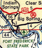
Washington
Indian Springs
Big Pool Big Spring |
MD 56
· Big Pool Rd.
9.46 mi.; from MD 68 west to US 40, Indian Springs.
Marked east-west. Kicking off Washington County's route cluster (56-68), MD 56 features several one-lane bridges, one dating back to 1907. 1.38 miles of this route north of I-70 are no longer state maintained, but included in the total mileage. |
56
0.0 US 401.5 I-70 12 9.5 MD 68 |
|
Washington
St. Paul's Church
|
MD 57
· Saint Paul Rd.
4.02 mi.; from US 40 at St. Pauls Church north to MD 494.
Marked north-south. So named because of the church at the route's southern terminus. MD 57 does not go to the PA line, but 494 does. Most maps don't tell which. |
57
4.0 MD 4940.0 US 40 |
|
Washington
Hagerstown
Cearfoss |
MD 58
· Cearfoss Pike, Salem Ave.
3.53 mi.; from Hagerstown limits northwest to MD 63.
Marked east-west. The road northwest of Cearfoss to the PA line is named 'Route 416', which it is - but PA 416. I wonder if it's a valid postal address. MD 58 ends just inside the corporate limits of Hagerstown, and isn't posted. This is also the case with Routes 60, 64, and 65. |
58
0.0 MD 633.2 I-81 7 3.5 Hagerstown line |
|
Frederick
Middletown
Jefferson |
MD 59
· was Holter Rd.
from MD 180 (then US 340) north to MD 17.
No longer assigned (decommissioned 1956). ................... |
|


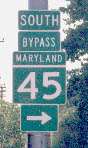 (right) A MD 45 Towson Bypass Marker.