|
| Routes: Interstates US Routes State Routes: | Home |
| US 50 (US 48) Prev (US 111) Next |
Quick Links: Marked
Decommissioned |
|
Garrett
Redhouse
Table Rock Gorman Prince George's
Cheverly
Landover Glenarden Bowie Anne Arundel
Annapolis
Skidmore Queen Anne's
Stevensville
Chester Grasonville Queenstown Wye Mills Talbot
Wye Mills
Skipton Easton Trappe Dorchester
Cambridge
Linwood Salem Vienna Wicomico
Mardela Springs
Hebron Salisbury Pittsville Worcester
Whaleyville
Berlin Ocean City |
US 50
· George Washington Hwy (western); John Hanson Hwy, Ocean Gateway, Sunburst Hwy (eastern)
150.06 total miles in Maryland
9.17 mi.; from WV line across tip of Maryland east to WV line at Potomac River.
140.89 mi.; from DC line near Cheverly east to MD 528, Ocean City.
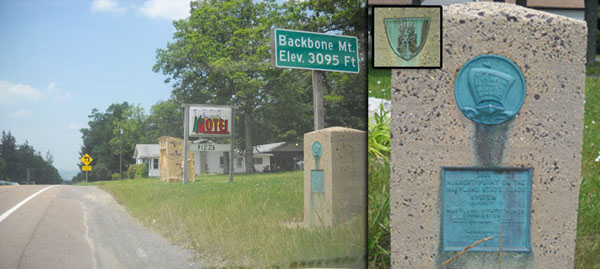
Status: Marked north-south. NHS: Entire eastern stretch in Maryland (DC Line to Ocean City). Portion from I-495 east to MD 70 in Annapolis is unsigned I-595; all Interstates (signed or not) are part of the NHS by default. Associated Secret-Obscure Routes: 346 450 662 731 750 908 950 Limited Access: from DC border east to US 50-301 split in Queenstown (~46 miles). US 50 in Maryland is more than just the route to the beach. It reaches sight of the ocean, yet also contains the highest point along any route in Maryland. Very little of its time in Maryland does it live up to its national reputation as "The Loneliest Road in America," unless you mean lonely in a crowd, perhaps. The western section of US 50, now George Washington Highway, began life as the Northwestern Turnpike of pre-auto days. Only here does 50 come anything close to the loneliness to be found further west. It's a small break in US 50's trip across West Virginia, proceeding into northern Virginia on its way to Washington, D.C.
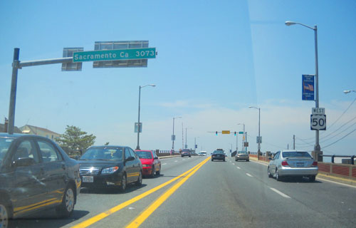
Exiting the District of Columbia along New York Avenue, US 50 reenters Maryland at the Kenilworth Interchange, connecting US 50, MD 201 (Kenilworth Avenue) and the Baltimore-Washington Parkway. US 50 from Washington to the Bay Bridge was Named for John Hanson, Maryland native and the first President of the Continental Congress under the Articles of Confederation, the predecessor to the U.S. Constitution. It would be complete between US 301 and MD 450 near MD 178 by 1950, west to MD 704 in 1957, and complete by 1960. The portion between I-495 and MD 70 would be added to the Interstate system as unsigned I-595 and upgraded in the early 1990s, using funds freed up from cancelled Baltimore-area freeways. It was decided not to co-sign the Interstate with US 50, given 50's existing brand recognition. For a short time, it was proposed that it be designated I-68, before that number was used for the National Freeway. On some signage along the hidden Interstate section, there remains some off-centered US 50 shields, with empty space next to it for I-595. The original eastern end of US 50 was at Church Circle in Annapolis, and its original path was today's MD 450. The western approach for the old ferry, and later of what became the Bay Bridge, roughly from MD 2 east to Skidmore, was completed by 1946, and designated part of MD 404. The Bay Bridge was opened in 1952, but US 50 had already been extended in 1949 onto the Eastern Shore via the existing ferry at Matapeake, taking over US 213 from Wye Mills all the way down to Ocean City. The original alignment (years bypassed by Ocean Gateway) then would have included today's MD 18, MD 662 (1948), MD 565 (1946), MD 750, MD 731 (1991), Main St (former MD 991) through Salisbury, MD 346 and MD 707. Over the years, US 50 across Kent Island would be upgraded to freeway conditions, returning the old road (and the Kent Narrows Drawbridge) to MD 18. It's now limited access all the way to the split with US 301, a total of 46 miles from Washington. The last remaining two-lane section on the Eastern Shore, near Vienna on the Nanticoke River, was bypassed in 1991, along with a new interchange with MD 331. The final change to US 50 occurred in 2002, when the Salisbury Bypass was extended westward from US 13 north of Salisbury. So now we have a 13-50 concurrency, and the old road became Business US 50. The eastern terminus of US 50 is at Baltimore Avenue (unsigned MD 378) in Ocean City. Leaving OC on the drawbridge over Assawoman Bay, the terminus is noted with a mileage sign: Sacramento 3073.
|
50 (w)
0.0 WV Line2.1 US 219 9.1 MD 560 9.2 WV Line
50 (e)
0.0 DC Line0.2 1 BW Pkwy 0.5 2 MD 201 1.6 3 MD 459 2.8 4 MD 202 4.1 5 MD 410 4.5 6 Ardwick-Ardmore 5.0 7 I-95-495 19 5.0 Begin I-595 6.1 8 MD 704 11.7 11 MD 197 13.1 13 MD 3 13.1 13 US 301* 14.4 PG-AA Line 16.5 16 MD 424 21.2 21 I-97 1 22.3 21 MD 665 23.0 22 MD 450 23.5 23 MD 2* 24.8 24 MD 70 25.0 End I-595 26.7 27 MD 2* 26.7 27 MD 450 27.6 28 Bay Dale Dr 29.2 29 MD 179 30.6 31 Whitehall Rd 31.4 32 MD 908 31.7 Toll (E/B $4.00) 34.3 Bay Bridge 34.3 AA-QA Line 37.2 37 MD 8 37.9 38a MD 835A 38.9 38b Service Rd 39.0 39a Castle Marina Rd 39.5 39b MD 552 40.1 40a Piney Creek Rd 40.5 40b Dundee Ave 40.8 41 MD 18 41.4 Kent Narrows Br 41.9 42 MD 835 41.9 42 Seward Marina Rd 42.8 43a Jackson Creek Rd 43.4 43b Chester River Beach Rd 43.8 44a Station Rd 44.2 44b Evans Ave 44.5 45a Hess Rd 44.9 45b Nesbit Rd 46.1 46 US 301* (Split) 46.3 MD 18 47.7 MD 456 49.1 Carmichael Rd 50.7 MD 662 51.6 MD 213 53.1 QA-TA Line 53.1 MD 404 55.4 MD 662 55.8 MD 662b 57.7 MD 662b 57.7 MD 662c 61.8 MD 309 62.7 MD 322 64.2 Matthewstown Rd 64.2 Goldsborough Rd 64.5 MD 331 65.4 Dutchmans La 66.9 MD 322 67.7 MD 565 78.5 Choptank Br 78.5 TA-DO Line 79.3 Maryland Ave 80.1 MD 343 80.8 MD 16* 81.2 MD 750 82.0 MD 750 83.5 MD 16* 93.5 MD 731 94.5 MD 331 95.4 Nanticoke Br 95.4 DO-WI Line 97.1 MD 731c 97.5 MD 731a 99.9 MD 54-313 104.8 MD 347 105.9 MD 670 107.8 Bypass (U/C) 110.4 MD 354 111.2 N Division St 111.5 US 13 Bus 112.3 MD 346 114.8 US 13 114.8 Bypass (U/C) 125.0 MD 354 126.5 WI-WO Line 127.3 MD 610 129.5 MD 90 131.5 MD 346 133.2 MD 818 133.5 US 113 134.4 MD 346 134.9 MD 452 136.1 MD 589 138.6 MD 707 139.4 MD 611 140.7 Sinepuxent Br 140.8 MD 528 140.9 MD 378 |