
|
| Routes: State Routes: Interstates US Routes | Home |
| Routes 180-199 (160-179) Prev (200-219) Next |
Quick Links: Marked Unmarked
Decommissioned |
|
Washington
Sandy Hook
Weverton Frederick
Knoxville
Jefferson Feagaville Frederick |
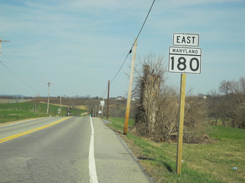
MD 180
· Jefferson Pike
14.63 mi.; from US 340 east to traffic light
at Himes Ave, Frederick (begin MD 351).
Status: Marked east-west. Associated Secret-Obscure Routes: MD 180 is the old 2-lane version of US 340, bypassed by a 4-lane limited access highway circa 1970.
|
180
0.0 US 3400.4 MD 478 2.0 MD 871 2.1 MD 17 3.8 MD 79 5.5 US 340 4 5.6 MD 872 7.7 MD 383 14.4 Himes Ave 14.5 US 15 14.6 Solarex Ct 14.6 MD 351 |
|
Anne Arundel
Ft. Meade
Odenton Gambrills Millersville |
MD 180
· was Annapolis Rd
old number for MD 175 south of Fort Meade.
No longer assigned (decommissioned 194x), now part of MD 175. This number was dropped when 175 was opened through Fort Meade. |
|
|
Anne Arundel
Annapolis
|
MD 181
· Sixth Street [Eastport, Annapolis]
0.16 mi.; Spa Creek Drawbridge in Annapolis.
Original extent decommissioned sometime before 1999, Spa Creek Drawbridge revived 2009. The latest 2009 Route Alert List confirms the return of 181 thus: MD 181 – Route number re-assigned to Spa Creek bridge (Struc #2053) in Annapolis. Originally MD 181 began at Forest Drive (which was MD 665 at the time), running north along Bay Ridge Avenue, then northwest along Sixth Street in the Eastport section of Annapolis to the bridge. It changes names to Compromise Street at the northern end of the bridge, as you enter the southern part of downtown Annapolis. Although it was decommissioned, 181 still showed up in documents concerning the drawbridge-it may have remained state operated and thus possibly 181 may have still been on the books, but only consisting of the bridge. ADC maps still show 'Route 181' written as text along Bay Ridge Ave. It's also the end of the Anne Arundel County cluster, now back we go to Montgomery County. |
|
|
Montgomery
Norwood
Layhill Woodmont |
MD 182
· Layhill Rd., Dr. Bird Rd.
6.60 mi.; from MD 97 near Woodmont north to MD 108 near Norwood.
Marked north-south. ................... |
182
6.6 MD 1084.5 MD 28 0.0 MD 97 |
|
Montgomery
Glenmont
Colesville |
MD 183
· was Randolph Road
from point 250 feet west of MD 97 east to MD 650.
No longer assigned (decommissioned). Dropped sometime after late 1976. Was also known as Glenmont Road. |
|
|
Montgomery
Silver Spring
|
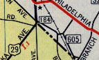
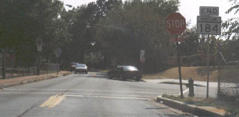
MD 184
· was Blair Road
between US 29 and DC line
No longer assigned (decommissioned 1999). Does a loop back into DC from US 29 at the line. There was an 'END 184' sign where Blair dips into DC for good.
MD 184 sign, from the intersection of US 29, and End 184 sign at the DC border, 1998.
|
|
|
Montgomery
Wheaton
Kensington Chevy Chase View N. Chevy Chase Chevy Chase Chevy Chase Section 3 Chevy Chase Section 5 |
MD 185
· Connecticut Ave.
8.30 mi.; from DC border at Chevy Chase Circle north to MD 97 in Wheaton.
Marked north-south. A major commuting artery. MD 185 once ended at 193, with 193 going to the DC line. South of 410, 185 was once Alt. US 240. All those Chevy Chase town names are separate incorporated areas. |
185
8.3 MD 976.0 MD 586 4.5 MD 193 4.4 MD 192 4.2 MD 547 2.6 I-495 33 1.4 MD 410 0.6 MD 191 0.0 Chevy Chase Cir 0.0 DC Line |
|
Montgomery
Silver Spring
|
MD 185
· was Juniper Street
~100 feet; bridge over railroad.
Decommissioned. Nothing remains of it. May have been the shortest route in the primary sequence (<379). Consisted mainly of a rail crossing. East end was near Montgomery College. The bridge that formed the bulk of this route is gone. In the map inset for 184 above, it is the short piece crossing the railroad between Routes 184 and 605.
|
|
|
Montgomery
Chevy Chase Section 3 Chevy Chase Section 5 Village of Martins Additions |
MD 186
· Brookeville Rd.
1.52 mi.; from Western Ave (DC border) north to MD 410.
Marked southbound, no cardinal directions; unmarked northbound. MD 186 is a minimally marked residential street with several 4-way stops and a 25 MPH limit through parts of Chevy Chase and Martin's Additions. It would seem likely that this route will be downloaded sometime soon.
|
186
1.5 MD 4100.0 Western Ave 0.0 DC Line |
|
Montgomery
Montrose
Oakmont Bethesda |
MD 187
· Old Georgetown Rd.
5.32 mi.; from MD 355 in Bethesda north back to MD 355 near Randolph Hills.
Marked north-south. Does a loop west of 355; another parallel to a often clogged commuter route.
|
187
5.3 MD 3553.8 I-270 1 3.4 Democracy Blvd 2.6 I-495 36 0.3 MD 188 0.0 MD 355 |
|
Montgomery
Glen Echo
Bethesda |
MD 188
· Wilson La.
3.25 mi.; from MD 187 in Bethesda west to MacArthur Blvd., Glen Echo.
Marked east-west. ...................
|
188
0.0 Macarthur Blvd0.9 MD 190 2.3 MD 191 3.3 MD 187 |
|
Montgomery
Rockville
Potomac Great Falls |
MD 189
· Falls Rd.
5.72 mi.; from MD 28 in Rockville southwest to MD 190 (River Rd.) in Potomac.
Marked north-south. ................... |
189
5.7 MD 284.8 I-270 5 3.3 Montrose Rd 0.7 Democracy Blvd 0.0 BSM |
|
Montgomery
Seneca
Travilah Potomac Campbell Cor. |
MD 190
· River Rd.
15.88 mi.; from DC line northwest to MD 112, Seneca.
Marked east-west. Passes through Potomac, which features some of the nation's most valuable real estate. |
190
0.0 MD 1123.0 Travilah Rd 8.1 MD 189 10.0 MD 191 11.5 I-495 39 13.8 MD 614 15.9 DC Line |
|
Montgomery
Campbell Corner
Bethesda Chevy Chase |
MD 191
· Bradley Blvd.
7.16 mi.; from MD 355 northwest to MD 190.
Marked east-west. MD 191 used to do an inverted-U shaped loop over I-495 out to MD 190, then returns inside the Beltway. The western end was rolled back in 1999 to MD 190. On the eastern end, it's a narrow neighborhood street which from the looks of it, would be closed as a through road or get speed bumps as soon as SHA drops the route. |
191
0.0 MD 1904.7 MD 188 5.5 MD 614 6.4 MD 355 7.1 MD 185 |
|
Montgomery
Kensington
|
MD 192
· Plyers Mill Rd, Metropolitan Ave, Capitol View Ave., Forest Glen Rd.
2.82 mi.; from MD 185 in Kensington east to US 29 near I-495 Exit 30 .
Marked east-west. ................... NHS: Between MD 97 and Belvidere Pl |
192
0.0 BSM0.4 MD 185 2.1 Forest Glen Rd 2.8 MD 97 |
|
Montgomery
Kensington
Wheaton Four Corners Takoma Park Prince George's
College Park
Greenbelt Glenn Dale Woodmore Kolbe's Corner Oak Grove |
MD 193
· University Blvd., Greenbelt Rd., Glenn Dale Blvd., Enterprise Rd., Watkins Park Dr.
26.15 mi.; from MD 185 near Kensington east to MD 202.
Marked east-west. Despite the loss of Connecticut Ave, 193 has grown longer over the years. Its original eastern end was at US 1 in College Park adjacent to the University of Maryland, taking a direct route through the campus. Circa 1956, the current route was built, bypassing the campus to the north, meeting US 1 near Greenbelt Rd (MD 430). There was one ramp from southbound US 1 to westbound 193, 193 then veered south to Greenbelt Rd, via which US 1 could be accessed. By 1964, MD 193 was extended east over Greenbelt Rd, taking over much of MD 430 with it, to the interchange with the B-W Parkway. Around 1968, 193 went east to MD 450 in Glenn Dale. At a later point (1970s?) came the final expansion, the bypass of the Glenn Dale grade rail crossing, taking over Enterprise Rd (MD 556) to the current eastern end of 193 at MD 202. |
193
0.0 MD 1851.2 MD 586 1.5 MD 97 4.3 US 29 4.9 I-495 29 6.2 MD 320 6.6 MD 195 6.7 MO-PG Line 7.0 MD 650 7.6 MD 212 8.8 Campus Dr 8.9 Adelphi Rd 10.1 Metzerott Rd 10.8 US 1 11.3 MD 430 12.5 MD 201 13.4 MD 968 13.6 B-W Parkway 17.1 MD 564 19.4 MD 450 20.3 MD 953 20.7 MD 974 24.0 MD 214 26.2 MD 202 |
|
Montgomery
Kensington
Chevy Chase View N. Chevy Chase Chevy Chase Chevy Chase Section 3 Chevy Chase Section 5 |
MD 193
· was Connecticut Ave.
Number changed on Connecticut Avenue portion of MD 193, now MD 185. Connecticut Ave south of current MD 193 was once also part of 193; it seems to have been changed to 185 around the time the Capital Beltway was built, thus avoiding two interchages with the same route number a few exits apart. |
|
|
Carroll
Taneytown
Keymar Frederick
Ladiesburg
New Midway Woodsboro Ceresville |
MD 194
· Francis Scott Key Hwy.
23.87 mi.; from MD 26, Ceresville northeast to PA line.
Marked north-south. Was once MD 71. Number changed to match with PA 194.. Associated Secret-Obscure Routes: 853 |
194
23.9 PA 19423.9 PA Line 18.7 MD 140 13.3 MD 77 12.4 FR-CR Line 7.0 MD 550* 6.5 MD 550* 0.0 MD 26 |
|
Montgomery
Takoma Park
|
MD 194
· was Flower Ave.
old number for MD 787
No longer assigned (decommissioned), now MD 787.
|
|
|
|
I-195
· Metropolitan Blvd
00.00 mi.; from ... to ...
|
|
|
Montgomery
Takoma Park
|
MD 195
· Carroll Ave.
1.90 mi.; from DC line northeast to MD 193, Takoma Park.
Marked north-south. ................... |
195
1.9 MD 1931.1 MD 787 0.5 MD 410* 0.4 MD 410* 0.0 DC Line |
|
Howard
Columbia
Scaggsville Montgomery
Burtonsville
White Oak |
MD 196
· was Old Columbia Pike
Unsigned south of Industrial Pkwy., decommissioned north of same to MD 198.
|
|
|
Prince George's
Laurel
Bowie |
MD 197
· Laurel-Bowie Rd., Collington Rd.
14.64 mi.; from MD 198, Laurel, south to US 301, Bowie.
Marked north-south. NHS: From US 50 north to Baltimore-Washington Pkwy (MD 295) Passes through Beltsville Agricultural Research Center. Though many routes in this range cross between Montgomery and Prince George's Counties, this is as good a point as any to begin the PG County cluster (197 through 223 or 224). |
197
14.6 MD 19811.8 B-W Pkwy 6.2 Jericho Park Rd 3.1 MD 450 1.7 US 50 11 0.0 US 301 |
|
Montgomery
Ashton
Spencerville Burtonsville Prince George's
Laurel
Anne Arundel
Maryland City
Ft. Meade |
MD 198
· Spencerville Rd, Sandy Spring Rd, Gorman Ave, Fort Meade Rd
12.98 mi.; from MD 32 near Fort Meade west to MD 650, Spencerville.
Marked east-west. NHS: From I-95 east to US 1 Near MD 32, 198 was once designated MD 602. The only reminder is a derelict sign and building, once called 'Club 602'. |
198
0.0 MD 6503.5 US 29 4.9 MO-PG Line 6.1 I-95 33 7.9 MD 216 8.4 US 1 8.8 MD 197 9.2 PG-AA Line 9.8 Brock Bridge Rd 11.1 B-W Pkwy 12.1 MD 216b 13.0 ESM |
|
Prince George's
Glenn Dale
|
MD 199
· was Glenn Dale Rd
from MD 564 south to MD 450.
No longer assigned (decommissioned 1953-55), entire route now MD 953. It now dead-ends at the Amtrak crossing near 564. It appears as 199 in the 1948 and 1953 map, and gone in '55. It's now bypassed by 193.
[There was a program in the 40s & 50s to eliminate railroad grade crossings with state highways.
Often the bypassed section remained under state maintenance with a more obscure number. Thus the 953 number may date from 1953-55.]
|


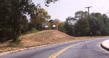 The remains of the original MD 185. The road is Blair Rd (former MD 184). MD 185 veered left into the knoll that
formed a railroad bridge abutment.
The remains of the original MD 185. The road is Blair Rd (former MD 184). MD 185 veered left into the knoll that
formed a railroad bridge abutment.

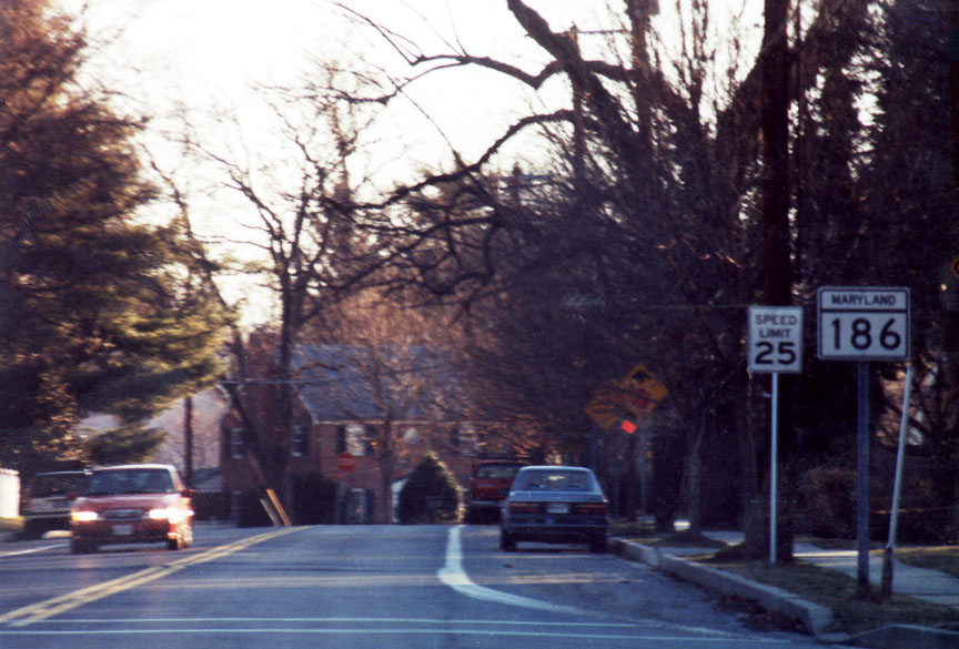 MD 186 sign, southbound (photo 02-18-01).

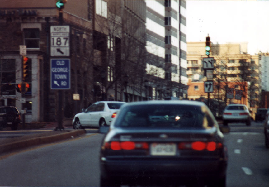 MD 187 (southern Terminus) turnoff viewed from MD 355 in Bethesda.

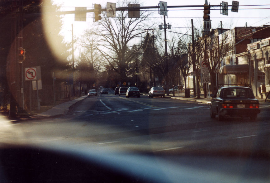 The obligatory view... MD 188 turnoff viewed from MD 355 in Bethesda.


