|
| Routes: State Routes: Interstates US Routes | Home |
| Routes 200-219 (180-199) Prev (220-239) Next |
Quick Links: Marked Unmarked
Decommissioned |
|
Montgomery
Redland
Norbeck Colesville Prince George's
Calverton
|
MD 200
· Intercounty Connector
(toll) ~17.4 mi.; from I-370 near Rockville/Gaithersburg east to US 1 south of Laurel.
Status: Signed east-west with yellow "TOLL" banner.
MD 200 Photo Gallery: ICC Opening Day MD 200 Photo Gallery: ICC Construction A western stretch of the Intercounty Connector, MD 200, opened February 23, 2010, between I-370 and MD 28. It features a short tunnel and automated full-speed electronic tolling. Apparently MD 200 will pick up its mileage points and exit numbers from I-370, which will end at the Shady Grove Metro. All traffic was routed up a temporary ramp to MD 28. The portion east of MD 97 to I-95 was opened November 22, 2011. The contracts were awarded in four sections for the ICC itself, plus a contract for an adjoining collector ramp on I-95. There are already bridge columns and abutments at I-95 and US 29, as well as the western end at I-370. The ICC will be Maryland's first experience with congestion pricing and demand-based toll rates. Montgomery County political and business leaders favored the ICC proposal, although Governor Glendening withdrew his endorsement for the project during his 1998 re-election campaign. At one point, Glendening favored the sale of the land set aside for the ICC. However, the plans were again revived under Governor Ehrlich upon taking office in 2003. The ICC received federal approval on May 30, 2006, and subsequently construction moved forward. The defeat of Ehrlich and return of Democratic state monopoly in the 2006 elections raised hopes once again for ICC opponents, but Governor O'Malley stayed the course, and remained in favor of completion. For more progress info, visit the ICC Project official site at www.iccproject.com.
|
200
2.5 I-3702.5 3 Metro Parking 8.2 9 MD 97 10.4 10 MD 182 13.2 13 MD 650 15.9 16 US 29 16.7 17 Briggs Chaney 17.2 MO-PG Line 18.6 19AB I-95 31 |
Prince George's
Capitol Heights
|
MD 200
· was Larchmont Rd.
from Old Marlboro Pike (old MD 4) north to MD 214.
No longer assigned (decommissioned). This one has had at least three names: Crystal Spring Ave. (as shown on the 1946 map, 57th Ave. by 1956, and the current name Larchmont Dr.
|
|
|
Prince George's
Beltsville
Greenbelt College Park Berwyn Heights Riverdale Edmonston Bladensburg Cheverly |
MD 201
· Kenilworth Ave., Edmonston Ave.
9.40 mi.; from DC line along B/W Pkwy north to MD 212 in Beltsville.
Marked north-south. NHS: between DC border and I-95/495. There's a MD 201 sign as you enter Maryland on the B-W Parkway. However, 201 leaves on the first exit, and MD 295 doesn't officially start until the end of federal maintenance at MD 175. MD 201 north of 450 in Bladensburg was formerly numbered MD 205. |
201
9.4 MD 2127.2 MD I-95/495 23 6.6 MD 193 - 3.9 MD 410 2.1 MD 450 1.1 B-W Pkwy 0.5 US 50 0.0 DC Line 0.0 DC 295 |
|
Prince George's
Bladensburg
Cheverly Landover Glenarden Brightseat Largo Oak Grove Upper Marlboro |
MD 202
· Largo Rd., Landover Rd.
13.92 mi.; from MD 450 in Bladensburg southeast to MD 725 near Upper Marlboro.
Marked east-west. NHS: between US 50 and Old Landover Rd. ................... |
202
13.9 MD 45013.4 B-W Pkwy 12.3 US 50 3 11.0 MD 704 9.6 I-95/495 17 7.6 MD 214 4.4 MD 193 0.0 MD 725 |
|
Prince George's
College Park
|
MD 203
· was College Ave.
east off US 1
No longer assigned (decommissioned). ...................
|
|
|
Montgomery
Takoma Park
Prince George's
Lewisdale
|
MD 204
· was Poplar Ave., Ray Rd.
from MD 195 in Takoma Park southeast to MD 212.
No longer assigned (decommissioned). |
|
|
Charles
Waldorf
|
MD 205
· was Mattawoman-Beantown Rd.
from US 301 south to MD 5 east of Waldorf.
No longer assigned (decommissioned 1998), now part of MD 5. Provides an eastern bypass of Waldorf and the current 301-5 junction. The 205 designation will probably be abandoned in the very near future, to become the new MD 5. It's already reflected on official maps, but as of mid-August 1998 the 205 signs were still there. |
|
|
Prince George's
Beltsville
Greenbelt College Park Berwyn Heights Riverdale Edmonston |
MD 205
· was Edmonston Ave.
from MD 450 north to MD 212.
No longer assigned (decommissioned), now part of MD 201. What is now MD 201 once met at a staggered junction in Bladensburg, thus there were separate numbers until it was became a straight intesection, at which time all of 205 became part of 201. |
|
|
Prince George's
Konterra
|
MD 206
· Konterra Drive, Virginia Manor Road
3.15 miles; from MD 212 north to Old Gunpowder Road.
Signed north-south at traffic signals. Added with the construction of an interchange with I-95 near the Intercounty Connector. The 206 designation doesn't appear on overhead signs on I-95 or on MD 200. |
|
|
Prince George's
Cottage City
|
MD 207
· Pennwood Rd, Cottage Terr, Perry St
02 parallel roads northeast of MD 206 on each side of Amtrak.
No longer assigned (decommissioned). Ran parallel to each other on opposite sides of Amtrak rail line. State maintenance ended at Bunker Hill Rd. Strange indeed. |
|
|
Prince George's
Hyattsville
Brentwood Cottage City Colmar Manor |
MD 208
· 38th Ave, 38th St, Hamilton St
1.86 mi.; from US 1 Alt north to MD 500.
Marked north-south.
It's surprising this one is still on the books; 208 is just a few streets running jaggedly along through the close-in incorporated suburbs of DC. From the one trip I made there some years back, it is all two-lane streets with curbs and no shoulder. Between US 1 and US 1 Alt was once numbered as MD 206. MD 208 isn't all state maintained, there's some municipal maintenance here on the part of Brentwood. It was all fairly well marked if things haven't changed since my last trip. |
208
1.9 MD 5001.4 Jefferson St 1.4 Hamilton St #1 0.5 Bunker Hill Rd #1 0.4 US 1 0.0 US 1 Alt |
|
Prince George's
Lewisdale
Hyattsville |
MD 209
· was Ager Rd.
from MD 500 east to US 1.
No longer assigned (decommissioned). MD 209 became part of MD 410, then dropped when 410 was diverted northward. |
|
|
Prince George's
Forest Heights
Oxon Hill Silesia Tantallon Accokeek Charles
Bryans Road
Potomac Heights Indian Head |
MD 210
· Indian Head Hwy.
21.27 mi.; from Indian Head naval facility north to DC line.
Marked north-south. NHS: south of I-95/495 to Berry Rd (MD 228). Indian Head Hwy began life as a unnumbered, federally maintained road, a straighter road to replace the more curved Livingston Rd (MD 224) which at that time was the main southern approach to DC. Associated Secret-Obscure Routes: 810 |
210
21.3 DC Line20.9 Livingston Rd 20.0 I-95/495 3 19.9 MD 414 19.5 I-295 - 18.4 Livingston Rd 17.4 Palmer Rd 16.7 Old Fort Rd 15.8 Ft Washington Rd 14.6 Livingston Rd 13.7 Old Fort Rd 11.6 Farmington Rd 10.3 MD 373 9.8 MD 228 9.6 Manning Rd 6.9 CH-PG Line 5.7 MD 227 2.0 MD 225 0.0 End |
|
Prince George's
Hyattsville
|
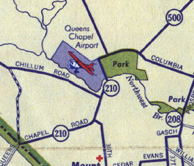
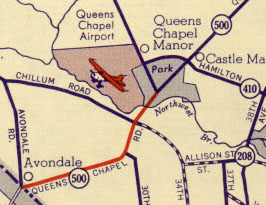
MD 210
· was Queens Chapel Rd.
old number from DC line to Ager Rd. (then MD 209)
No longer assigned (decommissioned), now part of MD 500. The map says it all...210 was covered over by 500 when Queens Chapel Rd was straightened out and run through the park. Nothing seems to remain of the airport. The DC line appears at bottom left.
Before and after of the MD 210 / MD 500 transition; (top) 1942, (bottom) 1952. |
|
|
Prince George's
Chillum Heights
|
MD 211
· was Sargent Rd.
1.1 mi.; from DC Line north to MD 212.
Decommissioned. MD 211 ended its existence as a zombie route. It no longer appears in the route logs or on the official map, but the removal wasn't in the Route Alert Lists.
|
|
|
Prince George's
Beltsville
Adelphi Lewisdale Chillum |
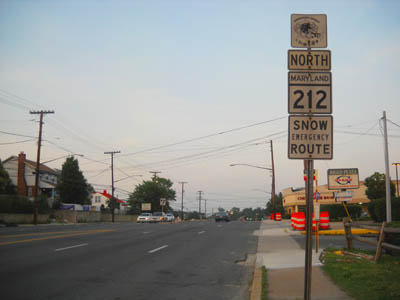
MD 212
· Riggs Rd., Powder Mill Rd.
10.48 mi.; from DC line northeast to MD 201, Beltsville.
Marked north-south. MD 212 runs north-northeast from the District line, then does a small loop back, crossing I-95 and US 1, meeting MD 201 in an L-shaped ending.
|
212
10.5 MD 20110.2 MD 694 10.0 US 1 8.1 I-95 29 6.8 Cherry Hill Rd 5.4 Powder Mill Rd 3.8 Adelphi Rd 3.6 Metzerott Rd 2.1 MD 193 1.3 MD 410 0.9 Sargent Rd 0.9 MD 211 0.2 MD 501 0.0 DC Line |
|
Cecil
Fair Hill
Cherry Hill Elkton Chesapeake City Cayots Cecilton Fredericktown Kent
Georgetown
Galena Locust Grove Kennedyville Chestertown Queen Anne's
Kings Town
Church Hill Starkey Corner Centreville Wye Mills |
MD 213
· Singerly Rd, Lewisville Rd, Augustine Herman Hwy, Church Hill Rd, Centreville Rd
68.25 mi.; from MD 662 in Wye Mills north to PA line.
Status: Marked north-south. Associated Secret-Obscure Routes: 537 812 MD 213 is the fourth longest state route, and eleventh overall at 68.25 miles. It was created when US 213 was decommissioned sometime in the late 1970s. US 213 until 1949 also consisted of all of current US 50 south of Wye Mills to Ocean City. The northern end was at US 40 in Elkton. When the US designation was dropped, MD 280 was absorbed into the new state route. Route 280 was the part of the current route north of US 40 to the Pennsylvania border. |
213
68.3 PA 84168.3 PA Line 66.7 MD 273 63.8 Leeds Rd (cir) 60.5 MD 279 60.1 MD 545 59.6 MD 7 59.1 US 40 54.4 MD 285 53.7 C&D Canal Bridge 53.2 MD 537 50.3 MD 310 43.8 MD 282 40.8 KE-CE Line 39.0 MD 290 39.0 MD 313 34.9 MD 444 34.8 MD 449 33.2 MD 298 33.0 MD 855 27.7 MD 561 25.5 MD 297 24.2 MD 291 23.3 MD 289 22.9 QA-KE Line 21.3 MD 544 17.1 MD 19 16.7 MD 300 15.8 MD 19 8.1 MD 305 7.5 MD 304 6.7 MD 18 5.2 US 301 4.2 MD 309 0.8 US 50 0.0 MD 662 |
|
Cecil
Kent
Queen Anne's
|
US 213
No longer assigned (decommissioned 1971). |
|
|
Prince George's
Capitol Heights
Seat Pleasant Largo Kolbe's Corr Hall Anne Arundel
Davidsonville
Steuart Cor Londontown Collinson Cor Selby Beach Mayo Beverly Beach |
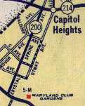
MD 214
· E Capitol St, Central Ave, Beverly Ave, Grande View Ave
24.97 mi.; from DC line east to road end at Beverly Beach.
Signed east-west. MD 214 runs roughtly parallel to and 3-5 miles south of US 50. Associated Secret-Obscure Routes: 332 977 978 |
214
0.0 DC Line0.8 MD 332 0.9 Addison Rd 3.7 I-95/495 15 4.1 MD 202 4.7 MD 977 6.8 MD 193 10.1 MD 978 10.5 MD 978 10.9 US 301 11.2 MD 978 13.4 PG-AA Line 16.1 MD 424 17.2 Riva Rd 19.1 MD 214a 19.5 MD 2 20.1 MD 253 20.4 MD 253a 20.8 MD 468 25.0 end |
|
Howard
Elkridge
|
MD 215
· was Lawyers Hill Rd., Levering Ave.
from US 1 northwest to Montgomery Rd.
No longer assigned (decommissioned). ................... |
|
|
Howard
Highland
Fulton Scaggsville Prince George's
Laurel
Anne Arundel
Annapolis Jct
|
MD 216
· Scaggsville Rd., 7th St., Old Portland Rd
9.06 mi.; from MD 108 southeast to MD 198, Laurel.
Marked east-west. Before the completion of its final link just northwest of its interchange with I-95, MD 216 was a broken route. The gap was bridged by unnumbered Leishear Rd.
This stub's junction with MD 198 was the scene of a light plane crash on May 4, 2007, which some news reports mentioned as being 'on Route 216'. Other than they busy adjacent MD 198, this road was the only clear landing site, otherwise it's surrounded by woods. Associated Secret-Obscure Routes: 983 |
216
8.4 MD 1987.9 Main St 7.8 HO-PG Line 6.9 I-95 35 5.8 Leishear Rd 5.4 MD 983 4.0 US 29 0.0 MD 108
216 (b)
0.0 End0.7 MD 198 |
|
Howard
Elkridge
Ilchester |
MD 217
· was Landing Rd.
from Ilchester Rd (former MD 104) south to Montgomery Rd. (former MD 103)
No longer assigned (decommissioned). ................... |
|
|
Prince George's
Suitland
|
MD 218
· Suitland Rd.
1.14 mi.; from MD 458 in Suitland northwest to DC border.
Marked north-south. ................... |
218
1.1 DC Line0.0 MD 458 |
|
Garrett
|
US 219
·
48.40 mi. in Maryland; from WV line near Gnegy Church north to PA line north of Grantsville.
Marked north-south. US 219 has its own page in the US Highway section. |
|
|
Garrett
Oakland
|
MD 219
·
Unmarked, possibly associated with proposed Oakland Bypass. ................... |
|

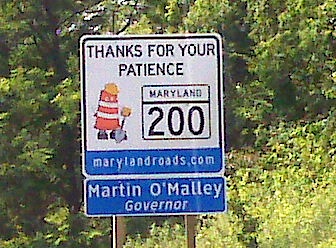 It's official...the ICC will be signed MD 200.
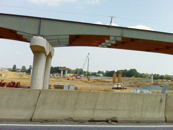
 Two of the many names of the former MD 200. Crystal Spring Ave. in 1946 (left)
and 57th Ave in 1956 (right). It has since been named Larchmont Dr. and stripped of the
200 number.
Two of the many names of the former MD 200. Crystal Spring Ave. in 1946 (left)
and 57th Ave in 1956 (right). It has since been named Larchmont Dr. and stripped of the
200 number.


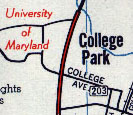 MD 203, from a 1956 General Drafting DC area map.


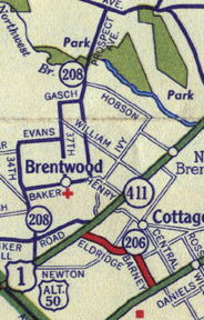 MD 208, from a 1942 map.


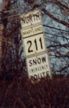 MD 211...catch it while you still can. (Photo 02-18-01)