
|
| Routes: Interstates US Routes State Routes: | Home |
| Routes 320-339 (300-319) Prev (340-359) Next |
Quick Links: Marked Unmarked
Decommissioned |
|
Montgomery
Takoma Park
Prince George's
|
MD 320
· Piney Branch Rd
2.84 mi.; from DC line north to MD 650.
Marked north-south. ................... |
320
2.8 MD 6502.1 MD 193 1.6 MD 787 0.4 MD 410 0.0 Eastern Ave NW 0.0 DC Line |
|
Howard
Elkridge
|
MD 321
· was Main St
east off Main St (former MD 477) east to dead
end.
No longer assigned (decommissioned). We now come to a numbering segment (320-327) that is all over the place with no rhyme or reason, and may have been left out in the original numbering plan. Otherwise, these numbers would be over on the middle Eastern Shore someplace originally. MD 321-322-323 are associated with the removal of a grade rail crossing in Elkridge. While 321 is Main Street, 322 and 323 were little stubs either side of the tracks. The east end of Main Street where it met US 1 (Washington Blvd) was lopped off to make way for the entrance ramp of what is now I-895 Exit 1. |
|
|
Talbot
Easton
|
MD 322
· Easton Pkwy
5.12 mi.; from US 50 around west side of Easton
back to US 50.
Marked north-south. This route provides a much-needed western bypass of Easton, shuttling traffic from MD 33 around Easton to US 50. It can also be a faster way through Easton than the commercial strip on US 50. |
322
5.1 US 504.6 MD 322B (662C) 3.0 MD 33 2.4 MD 334 1.6 MD 333 0.5 MD 565 0.0 US 50 |
|
Howard
Elkridge
|
MD 322
·
from ... to ...
No longer assigned (decommissioned). ................... |
|
|
Howard
Elkridge
|
MD 323
·
from ... to ...
No longer assigned (decommissioned). ................... |
|
|
Caroline
Preston
Choptank |
MD 324
· was Choptank Rd
from MD 331 in Preston southwest to Choptank.
No longer assigned (decommissioned). ................... |
|
|
Baltimore
Catonsville
|
MD 325
· was Wade Ave
from MD 144 just inside I-695 south to
entrance to Spring Grove State Hospital.
No longer assigned (decommissioned c. 1996). ................... |
|
|
St. Mary's
Leonardtown
|
MD 326
· was Washington St
from Business MD 5 (Fenwick St) in Leonardtown south to road end at waterfront of Breton Bay.
Decommissioned sometime before 1999. MD 326 used to stick down like an appendix off the loop that is Business MD 5 in Leonardtown. It looks like an unassuming residential street. Never saw it signed. |
|
|
Cecil
Perryville
|
MD 327
· Firestone Ave
0.36 mi.; from MD 7 south to end of state maintenance.
Marked north-south. Provides additional access to Perry Point VA Medical Center, which lies south of the Amtrak line. |
327
3.6 MD 7B0.0 ESM |
|
Charles
La Plata
|
MD 327
· was Valley Rd, Mitchell Rd
from MD 6 northeast to US 301
Marked north-south. Formed a loop north and west of La Plata. |
|
|
Talbot
Easton
Matthews Caroline
Denton
|
MD 328
· Matthewstown Rd, New Bridge Rd
15.24 mi.; from US 50 in Easton northeast to MD
404, Denton.
Marked east-west. Natural order is restored...we now come to Talbot County's allocation of numbers (328, 329, 331, 333 & 334). MD 328 runs northeast from Easton to Denton, with no state route intersections in the 14 miles in between. |
328
0.0 US 508.9 TA-CL Line 14.6 MD 404 Bus 15.2 MD 404 |
|
Talbot
Royal Oak
|
MD 329
· Royal Oak Rd
3.29 mi.; from MD 33 east back to MD 33.
Marked east-west. MD 329 forms a southern loop of MD 33, passing through Royal Oak. It may have been part of 33 in the distant past, before longer spans like 33's current bridge over Miles River were feasible. |
329
0.0 MD 333.3 MD 33 |
|
Kent
Massey
|
MD 330
· Massey-Delaware Line Rd
3.72 mi.; from Md 299-313 jct in Massey east to
Delaware line.
Marked east-west. ................... |
330
0.0 MD 3130.0 MD 299 0.0 DE Line |
|
Baltimore
Kingsville
|
MD 330
· was Jerusalem Rd
from US 1 (Belair Rd) northeast to Bradshaw Rd
No longer assigned (decommissioned). This was a small piece (~500 feet) or road that along with Belair Rd and Bradshaw Rd, forms the triangle that is the center of Kingsville. It was most likely unmarked, but may have remained as long as 1985. |
|
|
Talbot
Easton
Caroline
Bethlehem
Preston Dorchester
Hurlock
Shiloh Church Rhodesdale Vienna |
MD 331
· Dover St, Dover Rd, Dover Bridge
Rd, New Market-Ellwood Rd, Waddells Corner-Hurlock Rd, Shiloh
Church-Hurlock Rd, East New Market-Rhodesdale Rd, Rhodesdale-Vienna
Rd
29.25 mi.; from Washington St in Easton east
then south to MD 731 in Vienna.
Marked, unsure of cardinal directions. MD 331 was the original US 213 before the Choptank River bridge was opened in 1940. US 213 south of Wye Mills became part of US 50 only in 1949, so MD 331 was never part of US 50. Prior to 1940, the current US 50 from Vienna northwest to Cambridge was MD 344. MD 331 is co-signed with two other routes, MD 14 west of Rhodesdale, and MD 16 south of Preston to the 331 split near Hurlock. The southern section between Rhodesdale (MD 14) and Vienna runs along an abandoned rail line. Associated Secret-Obscure Routes: |
331
29.3 Washington St28.7 US 50 21.8 MD 578 18.4 MD 16* 18.3 MD 324 17.1 MD 318 13.8 MD 16* 11.4 MD 307 10.9 MD 392 8.0 MD 14* 5.9 MD 14* 0.0 US 50 |
|
Prince George's
Capitol Heights
|
MD 332
· Central Ave
1.07 mi.; from DC line east to MD 214.
Marked east-west. MD 332 is the part of Central Ave near the District line which was bypassed by a new MD 214, aligned with East Capitol Street. |
332
0.0 DC Line1.1 MD 214 |
|
Talbot
Easton
|
MD 322
· was Aurora St, Idlewild Ave, Dutchmans Lane
No longer assigned (decommissioned). A 1957 record describes 322 as 0.1 miles along Duchman's Lane. |
|
|
Talbot
Oxford
Trappe Easton |
MD 333
· Morris St, Oxford Rd, Peach Blossom Rd
9.79 mi.; from road end in Oxford northeast to
Washington St, Easton.
Marked, unsure of cardinal directions. ................... |
333
0.0 End9.4 MD 322 9.8 Washington St |
|
Talbot
Easton
|
MD 334
· Port St, Tred Avon Rd
1.03 mi.; from Washington St, Easton west to MD 322.
Marked east-west, but the opposite way as of 2000 (i.e. westbound is marked 'east). In 2001 the part west of MD 322 was dropped from state maintenance. The western end was at a boat ramp on Tred Avon Creek. ................... |
334
0.4 MD 3221.3 Washington St |
|
Dorchester
Church Creek
Hooper Island |
MD 335
· Golden Hill
Rd, Hooper Island Rd
16.36 mi.; from MD 16 in Church Creek west then
south to Hoopers Island bridge.
Marked north-south. Routes 335, 336, (339), 341, 343 and (344) were allocated to Dorchester County. |
335
0.0 ESM6.6 MD 336 16.4 MD 16 |
|
Dorchester
Lakesville
|
MD 336
· Golden Hill Rd, Lakesville Rd
4.87 mi.; from MD 335 east then south to end
of state maintenance at Andrews Rd.
Marked east-west.
The eastern end extended as far as Wingate, but has since been rolled back to Andrews Rd. Once extended to Crapo, and that's a real town name; even has a post office. |
336
0.0 MD 3354.8 Andrews Rd |
|
Prince George's
Camp Springs
|
MD 337
· Allentown Rd, Suitland Pkwy
3.41 mi.; from MD 5 east to MD 4.
Marked east-west, west of Suitland Rd; a North 337 marker exists just east of Suitland Rd. No signage on Suitland Pkwy portion.
MD 337 skirts along the northern edge of Andrews Air Force Base. The route includes part of federally maintained Suitland Parkway between Allentown Rd and MD 4, but 337 signage is not there on this segment. There's a last smattering of state maintenance adjacent to MD 4. |
337
0.0 MD 51.1 Andrews AFB Ent 1.6 Suitland Rd 2.8 Suitland Pkwy 3.4 MD 4 |
|
Cecil
Kilby Corner
|
MD 338
· was Rowlandsville Rd
from US 1-US 222 jct south to MD 222 north
of Port Deposit.
No longer assigned (decommissioned). Ran south of what is now the southern end of US 222. |
|
|
Montgomery
Silver Spring
|
MD 339
· was Sligo Ave
from US 29 east to MD 320.
No longer assigned (decommissioned 1999). A part of the 1999 decommissioning in exchange for Great Seneca Pkwy (MD 119). |
|
|
Dorchester
Rhodesdale
|
MD 339
· (name unknown)
small loop west off MD 331 just south of 392
No longer assigned (decommissioned). MD 339 shows up in a 1953 SRC map, with total length of 0.4 mi. |
|


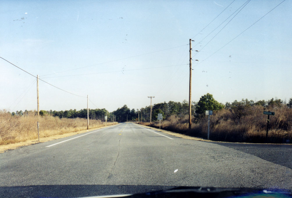 Southern beginning of MD 336 @ Andrews Rd. (picture 01/02/00)

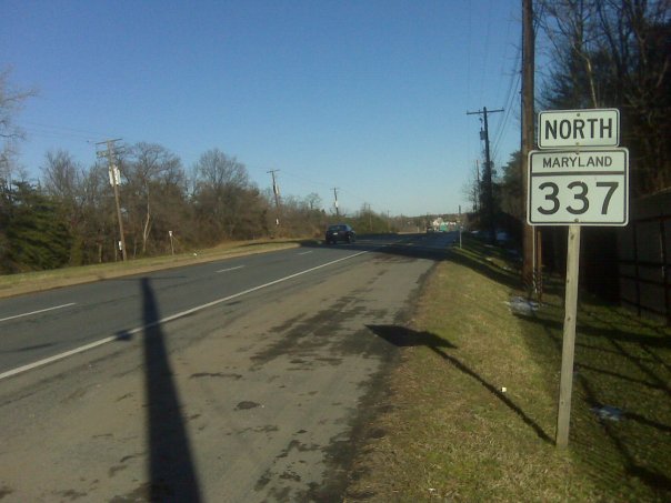 Lone North MD 337 signage, near Andrews AFB. All other, newer signage is east-west. (picture 12/27/09)

