
|
| Routes: Interstates US Routes State Routes: | Home |
| Routes 340-359 (320-339) Prev (360-379) Next |
Quick Links: Marked Unmarked
Decommissioned |
|
Washington
Frederick
|
US 340
·
12.30 mi. in Maryland; from VA Line east to US 40, Frederick
Marked east-west. US 340 has its own page in the US Highway section. |
|
|
Dorchester
Cambridge
|
MD 341
· Race St
1.25 mi.; from MD 16 north to MD 343.
Marked north-south. Created sometime between 1966 and 1970, when MD 16 was rerouted south of Cambridge. |
341
1.3 MD 3430.0 MD 16 |
|
Dorchester
Brookview
|
MD 341
· (unidentified)
loop south of MD 14 west of Brookview
No longer assigned (decommissioned). This was a short loop off MD 14 at Kelly Rd. |
|
|
Cecil
Chesapeake City
|
MD 342
· St. Augustine Rd.
2.82 mi.; from MD 310 north to MD 213.
Marked north-south. ................... |
342
2.8 MD 2132.8 MD 537 0.0 MD 310 |
|
Dorchester
Hudson
Cornersville Lloyds Cambridge |
MD 343
· Hudson Rd, Washington St
11.29 mi.; from beginning of state maintenance east to US 50 in Cambridge.
Marked east-west. Once ran through center of Cambridge turning northeast on High Street, then east on Maryland Ave to US 50. Washington St between High and Race Streets was MD 551; east of Race St was part of MD 16. Current configuration along Washington St dates from between 1966-70. |
343
0.0 BSM10.0 High St 10.4 MD 341 11.3 US 50 |
|
Charles
Doncaster
|
MD 344
· Chicamuxen Rd
2.16 mi.; from MD 224 east to MD 6.
Marked east-west. This route was once the southernmost end of MD 224. It seems odd these days as 344 is closer to 224's northern end than anything. But way back when 224 went north all the way to the DC border. The changeover from 244 to 344 occurred sometime between 1955 and 1960. MD 224's current route south of current 344 had been designated MD 563. MD 344 was previously named Gilroy Rd. |
344
0.0 MD 2242.2 MD 6 |
|
Dorchester
Cambridge
Linkwood Salem Vienna |
MD 344
·
from indeterminate point in Cambridge east to current MD 331, Vienna.
No longer assigned (decommissioned c. 1940), entire route now part of US 50. Prior to 1940, when the Choptank River bridge opened, what is now US 50 west of Vienna was designated MD 344. Its associated secret-obscure number was 750, so current 750 has nothing to do with current US 50 at all, just a very strange coincidence. Anyway, after 1940 this route became part of US 213, changing to US 50 in 1949. |
|
|
Garrett
Table Rock
|
MD 345
· was Table Rock Rd, Wilson Rd
from US 50 south to WV line.
No longer assigned (decommissioned 1950s). This one disappears in the 1955 state map. |
|
|
Wicomico
Salisbury
Pittsville Willards Worcester
Whaleyville
St. Martin Berlin |
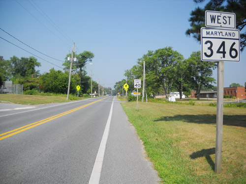
MD 346
· E Main St [Salisbury], Old Ocean City Rd, Old Ocean City Blvd
23.72 mi.; from Bus US 50 in Salisbury east to US 50 east of Berlin.
Marked east-west. MD 346 came into being sometime between 1963 and 1966, when the new 4-lane US 50 was built east of Salisbury. Routes 346-354 are in or close to Wicomico County.
|
346
0.0 US 50 Bus9.4 MD 353 12.9 MD 354 14.4 WI-WO Line 15.4 MD 610 20.1 US 50 22.3 MD 818 22.8 MD 377 22.9 US 113 23.7 US 50 |
|
Wicomico
Quantico
Hebron |
MD 347
· Quantico Rd.
6.92 mi.; from MD 349 south of Quantico northeast
to US 50 near Hebron.
Marked, no cardinal directions, as is often the case on the Lower Shore. It would probably be a north-south. ................... |
347
6.9 US 505.8 MD 670 0.0 MD 349 |
|
Wicomico
Sharptown
|
MD 348
· Laurel Rd.
1.39 mi.; from Eagles Ave in Sharptown southeast to
DE line.
Marked east-west. Also called Main St. west of MD 313 in Sharptown, Route 348 begins at that town's corporate limits, crosses the new MD 313 bypass, and quickly disappears into Delaware in less than a mile and a half. |
348
0.0 Eagles
Ave.0.1 MD 313 1.4 DE Line 1.4 DE 24 |
|
Wicomico
Nanticoke
Bivalve Catchpenny Salisbury |
MD 349
· Nanticoke Rd
22.32 mi.; from road end east to US 50 Bus.
Marked east-west. Associated Secret-Obscure Routes: 815 Little or no change on this route since the 1930s, with exception of current 815 once being part of it near the eastern end. |
349
0.0 End7.6 MD 352 15.1 MD 347 15.4 MD 352 21.5 MD 815 22.2 MD 815 22.3 US 50 Bus |
|
Wicomico
Salisbury
Mount Hermon Waste Gate Powellville |
MD 350
· Mount Hermon Rd
11.80 mi.; from begin of state maintenance east of Salisbury east to MD 354.
Marked east-west. ................... |
350
0.0 E Main St11.8 MD 354 |
|
Frederick
Frederick Church Hill |
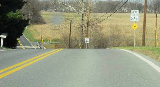
MD 351
· Ballenger Creek Pike
4.62 mi.; from MD 180 south to end of state maintenance.
Marked north-south. Prior to the mid seventies, this was MD 78, after which it became part of MD 180. The current designation dates from 1988. The route still ends in the same spot just north of Church Hill.
|
351
4.6 MD 1804.6 Solarex 0.0 BSM |
|
Wicomico
Fruitland
|
MD 351
· was Main St [Fruitland], Meadow Bridge Rd, Phillips Rd
1.77 miles; from Camden Avenue (former MD 663) to Little Brown Rd.
Status: Decommissioned 1955, transferred to Wicomico County maintenance. (SHA Min. 11-23-1955, Effective 11-23-1955). This appears to be the original 351 that would have fit into the clustering system. Dropped in 1955 along with a slew of other routes in the area. MD 513 now parallels the road a few blocks northeast, the new US 13 overpasses with no access.
|
|
|
Somerset
Marion
|
MD 351
·
between Marion and Tulls Corner
No longer assigned (decommissioned). Only mention of this 351 is in a 1937 operating budget. Perhaps a typo for MD 357. |
|
|
Wicomico
Capitola
Green Hill Catchpenny |
MD 352
· Capitola Rd, Whitehaven Rd
10.03 mi.; from MD 349 south then northeast back to MD 349.
Marked, unsure of cardinal directions. ................... |
352
0.0 MD 34910.0 MD 349 |
|
Wicomico
Pittsville
|
MD 353
· Gumboro Rd
4.60 mi.; from MD 346 north to MD/DE 54, DE line.
Marked north-south. MD 353 does not begin at US 50 as many think (it should), but where it always has, at the old US 50, now MD 346. At US 50 the signs read "TO MD 353." |
353
4.6 DE 264.6 DE 54 4.6 DE Line 4.6 MD 54 0.0 MD 346 |
|
Wicomico
Willards
Powellville Whiton Worcester
Indiantown
|
MD 354
· Powellville Rd, Whiton Rd
14.98 mi.; from US 50 south to MD 12.
Marked north-south. ................... |
354
15.0 MD 34614.8 US 50 10.5 MD 350 10.1 MD 374 7.6 WO-WI Line 0.0 MD 12 |
|
Frederick
Frederick
Urbana Montgomery
Hyattstown
Clarksburg Gaithersburg Rockville Montrose Bethesda |
MD 355
· Urbana Pike, Worthington Blvd [Urbana], Frederick Rd, Rockville Pike, Wisconsin Ave
41.04 mi.; from US 15 north of Frederick south to DC line.
Marked north-south. MD 355 is the original routing of US 240, prior to construction of Washington National Pike (current I-270) in stages beginning in the early 1950s. As sections were completed, the routing of US 240 was moved over to sections then open, and the old sections designated MD 355. The interchange with I-70 was removed in 2009, replaced with an interchange further east, with the extended MD 85. The northern terminus was also rolled back to I-70 south of Frederick in that year, although 355 signage remains in Frederick for the time being. New construction in Urbana resulted in the eastward rerouting of MD 355 in 2009, with the opening of the new Worthington Blvd, which crosses, but is mostly north of, MD 80. The original Urbana Pike was signed as Business MD 355 at its northern end. It has been touted as a bypass, but is more of a thruway, as new subdivisions and retail will line the new road. This project also includes the dualization of MD 80 east of I-270 in Urbana and in the vicinity of the new MD 355. |
355
41.0 US 1540.2 MD 26 37.8 MD 144 36.7 MD 85 30.4 MD 80 27.1 MD 75 26.8 MO-FR Line 26.5 MD 109 22.9 MD 121 19.7 MD 27 18.8 MD 118 15.4 MD 124 14.3 MD 117 12.7 I-370 9.7 MD 28 9.1 MD 660 8.7 MD 911 6.4 MD 187 5.3 MD 547 4.0 MD I-495 34 1.7 MD 187 1.6 MD 410 1.1 MD 191 0.0 DC Line |
|
Somerset
Crisfield
|
MD 355
· (name unknown)
.
No longer assigned (decommissioned). A 1937 SRC document describes MD 355 as "0.1 mile in the vicinity of Crisfield." |
|
|
Somerset
Kingston
|
MD 356
·
from MD 413 east in Kingston east to MD 667
No longer assigned (decommissioned). Routes 356-364 are clustered in Somerset County, with 356-360 all along the 413 corridor near Crisfield. |
|
|
Somerset
Marion
|
MD 357
· was Tulls Corner Rd
small piece east off MD 413.
No longer assigned (decommissioned c. 1990). A short route near Marion, straddling either side of MD 413. |
|
|
Somerset
Crisfield
|
MD 358
· Jacksonville Rd
1.13 mi.; N off 413 to Janes Island State Park.
Marked north-south. A small piece of MD 358 remains north off MD 413. Once extended south through Crisfield along Somerset Ave as well. The part in Crisfield was turned over to municipal maintenance in 1956. All routes south of Crisfield except MD 380 (which remains) was dropped by 1973. The map from 1967 says it all. The piece that remains today was once numbered MD 475. Sometime between the 1940-46 map editions (in the wartime period when no maps were printed), MD 358 took over this portion. From 1956-1973, MD 358 was a split route, when the (original) southern portion was dropped.
|
358
1.1 ESM0.0 MD 413 |
|
Worcester
Pocomoke City
|
MD 359
· Bypass Rd
0.20 mi.; from MD 756 south to dead end near US 113.
Signed north-south, but only at north end (MD 756). So named as it was the first bypass of US 113, which had originally used current MD 756. Dead-ends now as it was itself bypassed to the east by the current US 113. MD 359 now dead-ends at the American Legion hall on the corner of US 13 and 113. Connection is made with 113 a few hundred yards to the north via MD 359B, American Legion Dr. Sections of MD 359: |
359
1.1 MD 7561.1 MD 756 0.0 BSM |
|
Somerset
Crisfield
|
MD 359
· was Boone Rd
0.49 mi.; south off current MD 380
No longer assigned (decommissioned 1968). SHA records don't record the name for this road when it was dropped in 1968. |
|


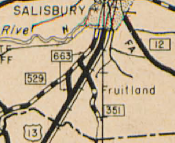 MD 351 south of Salisbury on the 1939 MD official map. MD 663 would have been Camden Ave. MD 529 still exists further south near Princess Anne.


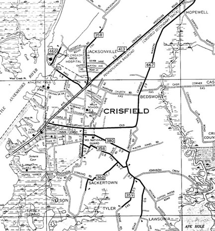 Crisfield area showing MD 358, 359, 360 from SHA map, 1967.