
|
| Routes: Interstates US Routes State Routes: | Home |
| Routes 440-459 (420-439) Prev (460-479) Next |
Quick Links: Marked Unmarked
Decommissioned |
|
Harford
Dublin
|
MD 440
· Dublin Rd
5.65 mi.; from MD 543 east to US 1.
Marked east-west. ................... |
440
0.0 MD 5433.9 MD 136 5.7 US 1 |
|
Cecil
Fair Hill
Providence |
MD 441
· was Providence Rd
from current MD 213 west to end of state maintenance.
No longer assigned (decommissioned). ...................
|
|
|
Kent
Betterton
|
MD 442
· was Royal Swan Rd.
~0.4 mi.; from MD 292 east to Stoneton Lane
No longer assigned (decommissioned). MD 442 last appears in the 1987 state map. Only the route is black indicating state maintenance, but there isn't room for the 442 marker. It disappeared sometime between 1987 and 1993. The routes from 442-449 are all in Kent County. It's our first large cluster in the numbers above 400. Of these, (signed) 444, 445, 446, (unsigned) 447 and 449 remain.
|
|
|
Kent
Coleman
|
MD 443
· was Still Pond Neck Rd
~0.9 mi.; from MD 292 to end of state maintenance near Coleman.
No longer assigned (decommissioned). Like 442, MD 443 disappears around the same time, 1987-93. |
|
|
Kent
Kentmore Park
Locust Grove Chesterville |
MD 444
· Kentmore Park Rd, Locust Grove Rd
7.29 mi.; from MD 290, Chesterville north to end of state maintenance at Belchester Rd.
Marked north-south. Once ended at a railroad crossing 2 miles north of the current southern end (Blacks Station). |
444
7.3 ESM4.3 MD 449 4.2 MD 213 0.0 MD 290 |
|
Kent
Tolchester Beach
Rock Hall |
MD 445
· Tolchester Rd, Main St, Eastern Neck Rd
11.96 mi.; from MD 21 near Tolchester Beach south to end of state maintenance
near Eastern Neck Island.
Markednorth-sou ................... |
445
12.0 MD 216.0 MD 20 0.0 ESM |
|
Kent
Langford
|
MD 446
· Broad Neck Rd
6.03 mi.; from MD 20 south to end of state maintenace at Langford Bay Rd.
Marked north-south. ................... |
446
6.0 MD 200.0 BSM |
|
Kent
Locust Grove
|
MD 447
· was Old Locust Grove Rd
from MD 444 east to MD 213.
No longer assigned (decommissioned). ................... |
|
|
Kent
Chestertown
Morgnec Chesterville |
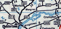
MD 447
· was Morgnec Rd
from MD 213, Chestertown east to MD 290, Chesterville.
No longer assigned (decommissioned), western portion now part of MD 291, small eastern portion part of MD 298. ...................
|
|
|
Kent
Kennedyville
|
MD 448
· was Kennedyville Rd, Turners Creek Rd
from Morgnec Rd (former MD 447) north to road end at Turners Creek Landing Park.
No longer assigned (decommissioned c. 1990). Was likely dropped at the same time that Browntown Rd, which parallels 448 about 1 mile to the east, was made part of an extended MD 298. |
|
|
Kent
Locust Grove
|
MD 449
· Shallcross Wharf Rd
0.07 mi.; from MD 213 east to MD 444.
Unmarked. Too short for any signage. Only 0.07 miles, or about 370 feet long, MD 449 is on the northwest corner of the MD 213/444 intersection. It's in the same vicinity as an incarnation of MD 447, which was on the northeast side. |
|
|
Cecil
Perryville
|
MD 449
· was Aiken Ave Ext, David N Clayton St
0.07 mi.; from MD 213 east to MD 444.
No longer assigned (decommissioned). This was an old part of 222 just north of US 40, bypassed by a bridge to replace the former railroad grade crossing. |
|
|
Prince George's
Bladensburg
Landover Hills New Carrollton Bowie Anne Arundel
Crofton
Parole Annapolis |
MD 450
· Annapolis Rd, Defense Hwy, West St, Church Cir, College Ave, King George St, Ritchie Hwy
30.42 mi.; from Bladensburg Rd (Alt US 1) east to US 50/US 301/MD 2 Exit 27.
Marked east-west. MD 450 came into being in the 1950s; as portions of the new US 50 were completed, these old sections would be numbered 450. It crosses the Patuxent River (the Prince George's-Anne Arundel county line) along a short co-signed segment with MD 3. (Prior to the new 50, this short duplex would have been US 50/301) It later underpasses I-97 with no direct access, but ample access is provided via US 50 near Annapolis Mall. Originally, US 50 ended at Church Circle in Annapolis, and College Ave/King George St were part of MD 2, which at the time went through Annapolis. When the new US 50 was built, MD 2 was rerouted and co-signed with 50 to bypass downtown Annapolis. MD 450 was extended along Ritchie Hwy to its current end at the Route 50 interchange. |
450
0.0 US 1 Alt0.3 MD 201 0.9 MD 202 1.5 MD 295 3.4 MD 410 4.7 I-95/495 20 5.0 MD 564 7.3 MD 704 7.9 MD 953 8.8 MD 193 11.5 MD 197 14.3 MD 3* 14.6 PG/AA Line 14.8 MD 3* 16.6 MD 424 23.9 MD 178 24.1 US 50/301 22 24.6 MD 2 24.7 MD 393 26.3 MD 435 26.3 MD 387 27.1 Church Cir 27.2 MD 70 27.3 King George St 28.0 MD 435 28.7 Severn Riv Bridge 28.9 MD 648 30.4 US 50/301 27 30.4 MD 2 |
|
Caroline
Andersontown
|
MD 450
· was Greenwood Rd
old number for current MD 16 between
MD 404 split east to Delaware border
No longer assigned (decommissioned 1940s), entire route now part of MD 16. MD 450 appears on a map from 1940, gone be 1946. |
|
|
Talbot
Claiborne
|
MD 451
· was Claiborne Rd
from MD 33 northwest to road end.
No longer assigned (decommissioned 1999). This was once MD 33, and the southern terminal of a ferry to Romancoke (current MD 8) on the southern tip of Kent Island. At the time, MD 451 was used for the current part of 33 south of Claiborne Rd to Tilghman Island. After the ferry service was terminated, 33 and 451 swapped, and 451 was now used for the spur to Claiborne. The number was dropped in 1999.
|
|
|
Worcester
Jones
Berlin |
MD 452
· Friendship Rd
1.64 mi.; from US 50 north to MD 575 (old US 113).
Marked north-south. Forms a shortcut between US 50 and 113 northeast of Berlin. |
452
1.6 MD 5750.1 MD 707 0.0 US 50 |
|
Washington
Exline
|
MD 453
· was Woodmont Rd
south off US 40 Scenic
No longer assigned (decommissioned). Runs south-southwest off Scenic 40 near I-68 Exit 78. |
|
|
Caroline
Templeville
Marydel |
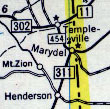
MD 454
· Crown Stone Rd, Halltown Rd
2.21 mi.; from MD 302, Templeville southeast to Delaware border, Marydel.
Marked north-south. So named because a crown stone on the Mason-Dixon Line lies alongside the road in Marydel. A so-called crown stone (with the Calvert and Penn coats-of-arms) was placed at every fifth mile instead of the simpler stones used every mile. MD 454 becomes DE 8 across the line. Associated Secret/Obscure Routes: 821
|
454
2.2 MD 3020.4 MD 821 0.1 MD 311 0.0 DE Line 0.0 DE 8 |
|
Wicomico
Delmar
|
MD 455
· was State St, Line Rd
old number for part of MD 54 straddling Delaware border east of Delmar
No longer assigned (renumbered May 15, 1968), entire route now part of MD 54. Dates at least as far back as 1937, when a planning budget notes 455 as State St in Delmar. The 1968 Rand McNally atlas shows both 54 and 455; this may be DE 54 and MD 455 together, as the parts entirely in Delaware are also marked 54. In the 1971 version, only 455 is shown again. The 1970 official Maryland map only shows 54, the 1966 version shows 455. The Delaware portion was designated Road 419.
|
|
|
Queen Anne's
Queenstown
|
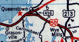
MD 456
· Del Rhodes Ave
1.22 mi.; from US 50 northwest to MD 18, Queenstown.
Marked north-south. Goes back at least to 1940. Serves now as a small cutoff between US 50 and 301 just east of the split.
Associated Secret/Obscure Routes: 656 |
456
1.2 MD 180.9 US 301 0.6 MD 656 0.0 US 50 |
|
Caroline
Greensboro
Burrsville |
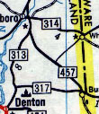
MD 457
· was Knife Box Rd
from MD 317 near Delaware border northwest to MD 313, Greensboro.
No longer assigned (decommissioned). Still appears in 1958, but likely gone by 1968.
|
|
|
Prince George's
Hillcrest Heights
Suitland District Heights |
MD 458
· Silver Hill Rd
3.12 mi.; from MD 5 northeast to Walker Mill Rd.
Marked, unsure of cardinal directions. Original east end was as MD 4, but later extended to Walker Mill Rd. On the west end, 458 curved northward at MD 414 before meeting MD 5, along what is now Old Silver Hill Rd. A new 458 was built, straight west 1/4 mile to MD 5, and Old Silver Hill Rd became part of MD 414, which it remains part of today. Associated Secret/Obscure Routes: 972 |
458
3.1 Walker Mill Rd2.4 MD 972 2.3 MD 5 1.4 MD 218 0.8 Suitland Pkwy 0.3 MD 414 0.0 MD 5 |
|
Prince George's
Cheverly
|
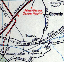
MD 459
· Columbia Park Rd, Tuxedo Rd., Kenilworth Ave.
1.25 mi.; from US 50 ramp near Cheverly Metro station west to MD 201 near B/W
Parkway interchange.
Unmarked. Originally this route was Cheverly Ave, running north through Cheverly to MD 202. This routing has since been dropped, and from near the southern starting point, now turns west on Tuxedo Rd, parallel to the north side of US 50. It then turns north onto the southernmost part of Kenilworth Rd up to the point where MD 201 comes in off the B/W Parkway and takes it over to points north.
|
|


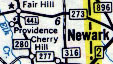 MD 441, from 1958 map. MD 280 is now MD 213.
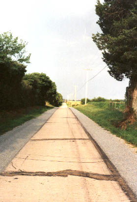 Remains of MD 442, 1998. Facing west from near the eastern end.
Several Kent County routes seem to have been paved in this fashion, with a concrete center portion.
This is opposite typical old routes, which have concrete shoulders. Just north of here is
Remains of MD 442, 1998. Facing west from near the eastern end.
Several Kent County routes seem to have been paved in this fashion, with a concrete center portion.
This is opposite typical old routes, which have concrete shoulders. Just north of here is 


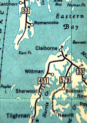 MD 451 shown on a 1954 map.


 MD 459 on a 1956 map. The current 459 turns west along what was then Arbor St over to Kenilworth Ave,
then north to meet the current MD 201.
MD 459 on a 1956 map. The current 459 turns west along what was then Arbor St over to Kenilworth Ave,
then north to meet the current MD 201.