
|
| Routes: Interstates US Routes State Routes: | Home |
| Routes 420-439 (400-419) Prev (440-459) Next |
Quick Links: Marked Unmarked
Decommissioned |
|
Montgomery
Laytonsville
|
MD 420
· was Brink Rd
from MD 124 west to Goshen Rd
No longer assigned (decommissioned). Likely decommissioned with the sweep of routes in the mid fifties. There aren't any old MD 420 signs around anymore to provide decoration for innumerable college dorm rooms. Were this route still on the books, sign replacement may have become an issue, as it did with NJ 69 (changed to NJ 31). |
|
|
Montgomery
Travilah
|
MD 421
· was Travilah Rd
from MD 190 northeast to end of state mainteance at Glen Rd.
No longer assigned (decommissioned) ...................
|
|
|
Anne Arundel
Bayard
Mt. Zion (Lothian) |
MD 422
· Bayard Rd
3.04 mi.; from end of state mainteance east to MD 2/MD 408.
Marked east-west. ................... |
422
0.0 Begin3.0 MD 2 3.0 MD 408 |
|
Anne Arundel
Fairhaven
|
MD 423
· Fairhaven Rd
2.79 mi.; from MD 2 east to end of state maintenance at Arundel Rd.
Marked east-west. ................... |
423
0.0 MD 22.8 ESM |
|
Anne Arundel
Conaways
Crofton Davidsonville |
MD 424
· Davidsonville Rd
8.24 mi.; from MD 3 southeast to MD 214.
Marked north-south. Associated Secret-Obscure Routes: ................... |
424
8.2 MD 35.6 MD 450 3.3 US 50/301 16 2.5 MD 909 0.0 MD 214 |
|
Charles
Mason Springs
Pisgah Ironsides |
MD 425
· Mason Springs Rd, Ironsides Rd
11.77 mi.; from MD 6 north to Md 224.
Marked north-south. Once only extended south to the junction of MD 6 at Ironsides. A small piece near the southern MD 6 junction near Nanjemoy was MD 491. |
425
11.7 MD 2244.8 MD 6 0.0 MD 6 |
|
Charles
Nanjemoy
|
MD 426
· was Liverpool Point Rd
from MD 224 east to MD 6.
No longer assigned (decommissioned). ................... |
|
|
Charles
|
MD 427
· was Chapel Point Rd
from US 301 west to end of state manintance at entrance to Chapel Point State Park.
No longer assigned (decommissioned). ................... |
|
|
Charles
Dentsville
Newport |
MD 428
· was Penns Hill Rd
from MD 6 south to MD 234.
No longer assigned (decommissioned). ................... |
|
|
Charles
Faulkner
Popes Creek |
MD 429
· was Popes Creek Rd
from US 301 southwest to road end.
No longer assigned (decommissioned). ................... |
|
|
Prince George's
College Park
|
MD 430
· Greenbelt Rd
0.49 mi.; from US 1 east to MD 193.
Unmarked. Once extended east to MD 201, but now all that remains is this small section, a connector in the US 1/MD 193 interchange, too short to be marked separately. |
|
|
Prince George's
College Park
Riverdale Park |
MD 431
· Campus Drive, River Road
2.06 mi.;from US 1 (Baltimore Avenue) southeast to MD 201 (Kenilworth Avenue).
Unsigned. Originally designated MD 594E, as part of the Purple Line construction. Renumbered at the request of SHA District 3 Part of the Purple Line right-of-way where it will run through College Park and into adjacent Riverdale Park. |
|
|
St. Mary's
Drayden
|
MD 431
· was Cherryfield Rd
south off Drayden Rd (former MD 244) to road end.
No longer assigned (decommissioned). ................... |
|
|
Howard
Columbia
|
MD 432
· Glen Oak La
0.25 mi.; from Guilford Rd (old MD 32/732) west to cul-de-sac.
Unmarked. MD 432 remains on the books, although the connecting part of Guilford Rd has lost its status as MD 732. |
|
|
Montgomery
Clarksburg
|
MD 432
· was Kingsley Rd, Hawkes Rd
between MD 121 and MD 27.
No longer assigned (decommissioned). |
|
|
Prince George's
New Carrollton
|
MD 433
· Elm Road, 85th Avenue
1.24 mi.l from Veterans Parkway (MD 410) east to Annapolis Road
Unsigned. Originally designated MD 594F, as part of the Purple Line construction. Renumbered at the request of SHA District 3 MD 433 accesses the north side of the New Carrollton Metro station, where the Purple Line will link into the Metro. Opposite the tracks is unsigned MD 950 to access the existing station. |
|
|
Caroline
Smithville
Federalsburg |
MD 433
· was Smithville Rd
from old MD 313 north of Federalsburg northeast to end of route
near Smithville.
No longer assigned (decommissioned). Appeared between 1949 and 1953, and dropped not long after. |
|
|
Prince George's
Beltsville
|
MD 433
· was Pringe George's Ave
No longer assigned (decommissioned). Appears on a 1940 state map, gone by 1946. |
|
|
Pringe George's
College Park
Berwyn Berwyn Heights |
MD 434
· was Pontiac St, 57th Ave, Berwyn Rd
from US 1 east to Edmonston Ave service road (old MD 201).
No longer assigned (decommissioned). Just a bunch of neighborhood streets now. The function of this route was largely replaced by MD 193, and MD 201 just past the eastern end is now 6-8 lanes wide. More info comes from Frank McConnell about Pontiac Street: |
|
|
Anne Arundel
Annapolis
|
MD 435
· Taylor Ave, Annapolis St
1.16 mi.; from MD 450 (West St) northeast to MD 450.
Marked north-south. State maintenance begins 0.3 miles north of West St (MD 450), roughly at the spot of an old rail crossing. Turns eastward onto Annapolis St for the last 0.2 miles to MD 450 at the edge of the Naval Academy campus. According to the 1953 state map, 435 once turned left at this point, going northwest on Annapolis St, then turning right, northeast on Severn Avenue to its end. The part of Annapolis St that is part of 435 now was MD 436, and current 436 (Ridgely Ave) was MD 438, named Revell St south of the drawbridge. The small part of Severn Ave between Annapolis St & Ridgely Ave would have been MD 437. The group of 435-438 are all in or near the neighborhood of West Annapolis. It's more north than west looking on a map, lying northeast of MD 70 (Rowe Blvd) and northwest of MD 435. |
435
1.2 MD 4501.0 Annapolis St 0.9 MD 436 0.8 MD 70 0.3 BSM 0.0 MD 450 0.0 MD 387 |
|
Anne Arundel
Annapolis
|
MD 436
· Ridgely Ave
1.14 mi.; from MD 436 (Taylor Ave) northwest to end of state maintenance at
Bestgate Rd.
Marked north-south. Associated Secret-Obscure Routes: Was once numbered MD 438 at some point, and was probably named Revell St. MD 436 features a swing type drawbridge of Weems Creek. Runs just east of the parallel MD 70 (Rowe Blvd). The secret/obscure routes are clustered up near 436's overpass of US 50. |
436
1.1 Bestgate Rd1.0 MD 784 0.7 MD 783 0.5 Drawbridge 0.2 Melvin Ave 0.0 MD 435 |
|
Anne Arundel
Annapolis
|
MD 436
· was Annapolis St
old number for current MD 435 between Taylor Ave and MD 450
No longer assigned (decommissioned), entire route now part of MD 435. |
|
|
Anne Arundel
Annapolis
|
MD 437
· was Severn Ave
from Ridgely Ave northeast to Annapolis St.
No longer assigned (decommissioned). |
|
|
Anne Arundel
Annapolis
|
MD 438
· was Ridgely Ave
old number for current MD 436
No longer assigned (decommissioned), entire route now MD 436. |
|
|
Baltimore
Maryland Line
Shane Harford
Shawsville
MD 439
· Old York Rd
|
7.19 mi.; from MD 45 southeast to MD 23.
Marked east-west. Associated Secret-Obscure Routes: MD 439 is only the northernmost part of the 'Old York Road', which carries all or part of three routes. From the southern end of 439, it goes south on current MD 23 for a while before diverting southwest, hitting MD 562 south of Monkton, carrying that number for a short distance before the end of SHA maintenance. It disappears south of MD 145, but once linked with current MD 146 (Jarrettsville Pike/Dulaney Valley Rd) merging again with York Road at the modern-day Towson Circle. There is also a section of Old York Rd inside Baltimore City limits. MD 439 was a broken route, with a piece up near the northwestern end, from York Road east to an indeterminate point west of Lentz Road, resuming at the Harford/Baltimore County line to MD 23. In 1979, the intervening stretch of unnumbered road was brought into state maintenance.
|
439
0.0 MD 450.2 I-83 36 6.0 BA-HA Line 7.2 MD 23 |


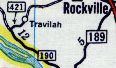 MD 421, from a 1958 General Drafting map.


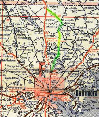 Baltimore County from early 1950s map, with Old York Rd highlighted in yellow.
MD 439 is at top. York Rd at the time was still US 111. The first piece of the pre-Interstate
Harrisburg Expressway also appears.
Baltimore County from early 1950s map, with Old York Rd highlighted in yellow.
MD 439 is at top. York Rd at the time was still US 111. The first piece of the pre-Interstate
Harrisburg Expressway also appears.