
|
| Routes: Interstates US Routes State Routes: | Home |
| Routes 400-419 (380-399) Prev (420-439) Next |
Quick Links: Marked Unmarked
Decommissioned |
|
Baltimore |
MD 400
· was Mt. Wilson La.
from MD 140 (Reisterstown Rd) west to former entrance of Mt Wilson State Hospital
Status: Decommissioned 1989, number no longer assigned. Mt. Wilson State Hospital was closed in June 1981. Route 400 was dropped in 1989, with signage lasting a few years longer. Like 325 and 479, other entrances to former state mental hospitals, when these institutions were closed and the land sold to other interests, the route numbers were dropped. |
|
|
Baltimore |
MD 401
· was Stringtown Rd.
2.13 mi.; from MD 25 (Falls Rd) northeast to intersection with Yeoho Rd & Cold Bottom Rd.
Status: Decommissioned 1985, number no longer assigned With all the busy, unnumbered modern day roads in Hunt Valley connecting Falls Rd (25) and York Rd (45) with I-83 (Timonium, Padonia, Shawan, Belfast), the only numbered road in the area was this one, which goes no place in particular. The only numbered road to even cross I-83 south of Hereford, Seminary Ave (131), offers no connection to I-83 at all. |
|
|
Calvert |
MD 402
· Dares Beach Rd.
4.33 mi.; from MD 2/4 east to road end.
Status: Marked east-west. Associated Secret-Obscure Routes: 768 MD 402 is another Calvert County branch route from the trunk that is MD 2/4. MD 768 is the loopback road in Dares Beach. |
402 |
|
Prince George's |
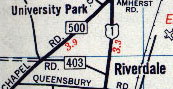
MD 403
· was Colesville Rd
old number for current MD 410 between US 1 and MD 500.
Status: Now part of MD 410 (East-West Hwy), number no longer assigned.
|
|
|
Harford |
MD 403
· was Level Rd
loop north off US 1 (Conowingo Rd) just west of MD 161
Status: Decommissioned. Appears on a 1937 map and SRC operating budget, and little else. Possibly an old alignment of MD 155. |
|
|
Queen Anne's
Talbot
Wye Mills
Queen Anne Caroline
Hillsboro
Denton Andersontown |
MD 404
· Queen Anne's Hwy, Shore Hwy
24.61 mi.; from MD 213/662 in Wye Mills east to Delaware state line east of Andersontown.
Status: Marked east-west. NHS: All except small piece at western end, between US 50 and MD 213/662. Associated Secret-Obscure Routes: 485 A long-time main drag on the Eastern Shore, and an alternate to US 50 in reaching the ocean, particularly the Delaware resorts. MD 404 goes back to the beginning of the numbering system. Before the completion of the Bay Bridge, 404 extended all the way across the Bay to what is now the US 50/301-MD 2/450 interchange (Exit 27). A ferry went between Sandy Point (roughly where the Bay Bridge toll plaza is today) and Matapeake on the western shore of Kent Island. MD 404 went north from Matapeake along current MD 8, then east on MD 18 (which it superceded on maps; there was no dual 18/404 on any maps), and east on current US 50/MD 662 to the current western end at Wye Mills. The number rollback to MD 662 in Wye Mills occurred in August 1984. MD 404 also forms the Talbot-Queen Anne's county line and near Andersontown is home to the only instance of three concurrent state routes: 404, 16 and 313. 50 southeastEast of Wye Mills, 404 ran through Queen Anne and Hillsboro before reaching Denton. A busy, flat and straight 2-lane highway, 404 in recent years has experienced many serious accidents, averaging 72 per year from 1995-99, and 46 fatalities in the last 20 years. For more, check out 404-The Forgotten Highway, an account of 404's safety problems. |
404
0.0 MD 6621.0 US 50 5.7 TA-CL Line 6.8 MD 309 7.0 MD 303 8.0 MD 480 9.1 MD 404 Alt 9.4 MD 485 10.0 MD 485 10.3 MD 312 12.8 MD 404 Bus 13.7 MD 328 14.7 MD 313 14.7 MD 619 16.1 MD 404 Bus 18.2 MD 16* 20.5 MD 313* 21.4 MD 16* 21.4 MD 313* 24.6 DE Line |
|
Talbot
Queen Anne
Caroline
Hillsboro
|
MD 404 Alternate
· Millsboro-Denton Rd, Talbot Ave, Hillsboro Rd
2.69 mi.; from MD 309 east to MD 404.
Status: Marked east-west. Also part of the old 404, running through Queen Anne and Hillsboro. Not enough business along it to qualify for that banner here. Associated Secret-Obscure Routes: 485 |
404 Alt
0.0 MD 3090.5 MD 303 0.6 MD 303 0.7 MD 518 1.0 TA-CL Line 2.9 MD 404 |
|
Caroline
Denton
|
MD 404 Business
· Meeting House Rd, Franklin St
2.32 mi.; from MD 404 east through Denton back to MD 404.
Status: Marked east-west. Comprises the old 404 through Denton. |
404 Bus
0.0 MD 4040.8 MD 308 1.7 MD 619 2.3 MD 404 |
|
Queen Anne's
Price
Roe |
MD 405
· Price Station Rd
8.59 mi.; from MD 19 near Church Hill southeast to MD 304.
Status: Marked north-south. |
405
8.6 MD 196.0 US 301 0.0 MD 304 |
|
Somerset
Hudson's Corner
Rehobeth |
MD 406
· was Rehobeth Rd
old number for part of MD 667 between Hudson's Corner and US 13
Status: Entire route became part of MD 667 in 1961, number no longer assigned. Prior to 1961, MD 667 (and before that, MD 413) ran north along Old Westover-Marion Rd to Westover, and Rehobeth Rd (the current 667) was numbered 406. |
|
|
Carroll
Marston
|
MD 407
· Marston Rd
3.81 mi.; from MD 31 east to MD 27.
Status: Marked east-west. Not a lot here, just a 3-way stop and L-intersection in the hamlet of Marston. |
407
0.0 MD 313.8 MD 27 |
|
Anne Arundel
Waysons Cor.
Greenock Mt. Zion (Lothian) |
MD 408
· Mount Zion-Marlboro Rd
5.62 mi.; from MD 4 east to MD 2.
Status: Marked east-west. MD 408 is the old path of MD 4 before the latter was shifted south along Southern Maryland Blvd (originally designated 416) sometime between 1964-66. |
408
0.0 MD 40.0 MD 980 1.5 MD 794 4.2 MD 259 5.6 MD 422 5.6 MD 2 |
|
Harford
Edgewood
|
MD 408
· was Edgewood Rd
from MD 7 south to APG Edgewood Area gate.
Status: Part of route south of US 40 is now MD 755, number reassigned. MD 408 was likely changed to 755 at the same time as the arrival of the current 408 in southern Anne Arundel Co. MD 24 once had its southern end at MD 7, and 408 was the main road extending south. MD 24 now bypasses this whole road. The part of 408 between MD 7 and US 40, which includes a one-lane railroad underpass, was recently dropped as part of 755. |
|
|
Baltimore
Freeland
Maryland Line |
MD 409
· was Freeland Rd, Harris Mill Rd
2.41 mi.; from MD 45 west to NCRR crossing in Freeland.
Status: Decommissioned 1989, number no longer assigned. Associated Secret-Obscure Routes: 884 Another Baltimore County spur, this one ending at the old railroad crossing in the town of Freeland. MD 409 was realigned slightly north at its intersection with MD 45 (York Road) in Maryland Line, to line up with the approach to I-83 Exit 37. Dropped in 1989 as part of the exchange that brought Security Blvd into the state system as MD 122. |
|
|
Montgomery
Bethesda
Chevy Chase Silver Spring Takoma Park Prince George's
Lewisdale
University Park Hyattsville Riverdale Park Landover Hills Glenarden |
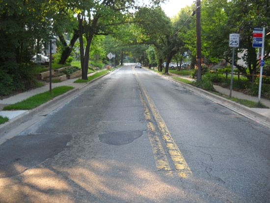
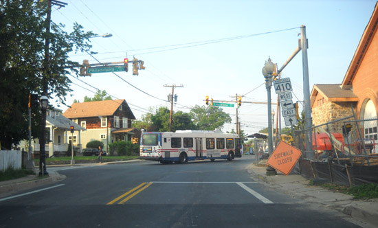
MD 410
· Montgomery Ave, East-West Hwy, Burlington Ave, Philadelphia Ave [Takoma Park], Ethan Allen Ave [Takoma Park], East-West Hwy, Riverdale Rd, Veterans Pkwy
13.92 mi.; from MD 355 in Bethesda east to road end south of US 50 near Glenarden.
Status: Marked east-west. The sections of MD 410 near Silver Spring were completed in 1932-33 (it's unknown whether it got the 410 number that early too). By 1951, 410 had taken over old MD 209 (Ager Rd.) to MD 500, running east on Hamilton St to 40th Ave. In Prince George's County is a continued oddity, there remains a 0.35 mile gap in state maintenance east of the interchange with the Baltimore-Washington Parkway. More breaks in state maintenance occur in Takoma Park, where SHA and the city are in talks to determine maintenance. According to SHA's HLR database, the maintenance transitions appear to be quite specific, down to 0.01 mile. But real property records were not well kept, and neither side can prove definitive ownership. There is no documentation to back up these maintenance claims, but they do serve as a starting point of any future movement on the matter. Mileages are from the beginning of 410 in Bethesda.
While this is being hammered out, SHA and Takoma Park have agreed to decouple the pending download of MD 787 (Flower Ave) to city maintenance.
|
410
0.0 MD 3551.0 MD 185 1.4 MD 186 3.5 MD 390 3.7 MD 384 4.2 US 29 5.0 MD 320 5.5 MD 195* 5.6 MD 195* 6.3 MD 650 6.3 MO-PG Line 7.2 MD 212 9.0 MD 500 9.5 US 1 10.6 MD 201 10.8 BW Pkwy 12.8 MD 450 13.5 US 50 5 13.9 Pennsy Dr |
|
Prince George's
Bladensburg
|
MD 411
· was Rhode Island Ave
from DC line northeast to Alt US 1.
Status: Entire route now part of US 1, number no longer assigned. MD 411 appeared along with US 1 on old 1940s road maps of the DC area. |
|
|
Prince George's
Riverdale
Edmonston |
MD 412
· was Riverdale Rd
.
Status: Decommissioned 1990, number no longer assigned. This route was likely dropped because it parallels modern MD 410, lying only a few blocks to the south. First there was a truncation between US 1 and Rhode Island Ave in 1974. The other part of Riverdale Road, MD 412A, from MD 201 west to Lafayette Ave, was dropped in 1990. More info about 412 comes from Mark Cleveland: |
|
|
Somerset
Westover
Kingston Marion Hopewell Crisfield |
MD 413
· Crisfield Hwy, Richardson Ave/Maryland Ave, W Main St
14.61 mi.; from US 13 southwest to road end in Crisfield.
Status: Marked north-south. MD 413 is present in just about every map in which state route numbers are shown. I have no evidence that it was ever planned to be US 413. A new, straighter 413 was completed in 1950 alongside the abandoned rail alignment to Crisfield. The completed sections extended from Crisfield north to Hopewell in 1940 and to Marion by 1946. As new parts were opened, the old road would be assigned MD 667, which remains today, but the section north from Hudson's Corner was shifted eastward along old MD 406 to US 13. Associated Secret-Obscure Routes: |
413
14.6 US 1314.1 MD 673 13.3 MD 361 6.0 MD 667 3.5 MD 667 1.4 MD 358 1.3 MD 460 0.0 Begin |
|
Prince George's
Forest Heights
Oxon Hill Hillcrest Heights Suitland |
MD 414
· Oxon Hill Rd, St. Barnabas Rd, Old Silver Hill Rd, Bonita St
5.11 mi.; from MD 210 east to MD 5.
Status: Marked east-west. An interesting feature at the eastern end: MD 414 officially curls northward on an old alignment of MD 458, ending at MD 5. West on the route here is southeast geographically. We'll likely see this portion lopped off the next time Prince George's County needs lane-miles elsewhere. |
414
0.0 MD 2101.7 I-95/495 4 4.0 MD 5 4.6 MD 458 5.1 MD 5 |
|
St. Mary's
Pt. Lookout
|
MD 415
· was Scotland Beach Rd
from MD 5 east to road end.
Status: No longer assigned (decommissioned 1950s). A tiny spur off MD 5 down near Point Lookout. |
|
|
Anne Arundel
Calvert
|
MD 416
· was Southern Maryland Blvd
from current MD 4-408 jct southeast to current MD 2-4 split in Sunderland.
Status: Entire route now part of MD 4, number no longer assigned. Prior to MD 4 being extended southward along Southern Maryland Blvd, 4 went east along what is now MD 408, ending at MD 2. SM Blvd between 4 and 2 was originally MD 416. Later it was extended south along MD 2 for the length of Calvert County, creating a long 2/416 dual signage. MD 416 disappeared when MD 4 took over its entire length, the old 4 becoming 408, and the long dual route 2/4. |
|
|
Garrett
Grantsville
|
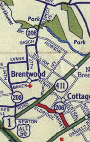
MD 417
· was Springs Rd
from US 40 north to PA border.
Status: Changed to MD 669 in 1963. This number was changed to match the adjacent PA 669, assigned April 1, 1963.
|
|
|
Washington
Leitersburg
Ringgold |
MD 418
· Ringgold Pike
4.62 mi.; from MD 60 northeast to Pennsylvania border.
Status: Marked east-west. |
418
0.0 MD 602.7 MD 64 2.8 MD 846 4.6 PA Line 4.6 PA 2007 |
|
Montgomery
Dickerson Stronghold |
MD 419
· was Martinsburg Rd, Dickerson Rd
from bridge near C&O Canal northeast to end of state maintenance
.5 mi. west of Mt. Ephraim Rd.
Status: Decommissioned, number no longer assigned. A two-part route, with intervening section of MD 28. |
|


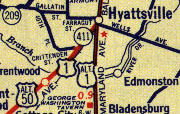
 MD 403 in Hyattsville, 1956. Section of future MD 410 to west is under construction.


 MD 417 shown on a 1958 map.
