|
| Routes: Interstates US Routes State Routes: | Home |
| Routes 620-639 (600-619) Prev (640-659) Next |
Quick Links: Marked Unmarked
Decommissioned |
|
Carroll
Taneytown
|
MD 620
· was Trevanion Rd.
from MD 84 west to Taneytown.
No longer assigned (decommissioned 1950s). Once only consisted of a small stub near Taneytown. By 1955 it consisted of the entire distance to MD 84. Presumed decommissioned circa 1956. |
|
|
Caroline
Harmony
American Corner |
MD 621
· was Grove-Agner Rd. (now Auction Rd)
between MD 16 and MD 313
No longer assigned (decommissioned 1970s). East of American Corner, this was part of MD 313, later shifted eastward. MD 621 was still on the maps into the seventies. In the early 2000s, the former route was renamed Auction Road, apparantly named after an auction house along the road just east of American Corner. I'll leave the old name above for now, since it was never Auction Road and MD 621 at the same time. Forming the other crossroads of American Corner are two other former routes. MD 621 was the east-west; to the north was MD 630, and to the south was MD 617. The eastern part of MD 621 and MD 630 were once part of MD 313. |
|
|
Carroll
Westminster
Warfieldsburg |
MD 622
· was Stone Chapel Rd
3.27 mi.; from MD 31 (Avondale) to MD 27 (Warfieldsburg) (2 sections at one point).
Status: Decommissioned 1955; transferred to Carroll County maintenance. (SRC Min. 09-14-1955, Effective 07-01-1956) This mysterious L-shaped route ran south of MD 31 (now the 'old' 31, or 852), then east to MD 27. In 1948, there were two non-contiguous sections, a small stub south of MD 31 and the other going east from the intersection of Chapel and Stone Chapel east toward, but not touching, MD 27. Everything in this area has been widened, in likely anticipation of development. |
|
|
Harford
Broad Creek
Darlington |
MD 623
· Flintville Rd., Castleton Rd.
7.26 mi.; from MD 161 near US 1 north to PA Line.
Marked north-south. |
623
7.3 PA 20437.3 PA Line 0.2 US 1 0.0 MD 161 |
|
Harford
Pylesville
|
MD 624
· Graceton Rd.
3.02 mi.; from MD 165 north to PA Line.
Marked north-south. |
624
3.0 PA 20803.0 PA Line 2.7 MD 136 0.0 MD 165 |
|
Charles
Hughesville
|
MD 625
· Old Leonardtown Rd
1.36 mi.; from MD 5 into Hughesville.
Status: Signed as Business MD 5. MD 625 is the hidden designation for Business MD 5 in Hughesville, established in 2006 as the MD 5 Hughesville Bypass was completed. Sections of MD 625: |
|
|
Frederick
Sabillasville
Pen Mar |
MD 625
· was Old Sabillasville Rd
1.49 mi.; from Sabillasville to PA line.
Status: Decommissioned 1955; transferred to Frederick County maintenance. (SRC Min. 09-14-1955) This MD 625 is an old alignment of MD 81 (now MD 550). Though 550 continues west into Washington County, old 625 runs northwest into Pennsylvania just short of the Frederick-Washington County tripoint. |
|
|
Worcester
West Ocean City
|
MD 626
· was Golf Course Rd, Sunset Ave
0.72 mi.; from MD 707 south, east to road end.
Status: Decommissioned 2001, transferred to Worcester County maintenance, was officially 626A. An L-shaped route, south on Golf Course Rd, then turning east onto Sunset Ave. |
|
|
Somerset
Oriole
|
MD 627
· Oriole Rd.
2.48 mi.; from MD 363 soutwest to Crab Island Rd., Oriole.
Marked east-west. When I first saw 627 and the town of Oriole on a map, I thought it had to be some kind of 'copyright trap' put in by a mapmaker. But they are really there, and 627 has been around at least since 1940. |
627
0.0 Crab Island2.5 MD 363 |
|
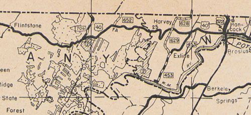
Allegany
Harvey
|
MD 628
· was Rice Rd
3.82 mi.; from US 40 (now Western Pike) at Harvey to end of state maintenance.
Status: Decommissioned 1955; transferred to Washington County maintenance. (SRC Min. 05-06-1955, Effective 07-01-1955) Rice Rd continued past the end of maintenance. The current Scenic 40 bypassed the intersection that is Harvey.
|
|
|
Allegany
Harvey
Exline |
MD 629
· was Exline Rd
2.66 mi.; from US 40 at Harvey to Woodmont Rd at Exline (former MD 453).
Status: Decommissioned 1955; transferred to Washington County maintenance. (SRC Min. 05-06-1955, Effective 07-01-1955) Deleted along with 628 in this area. See the map above for the route layout here. |
|
|
Caroline
Federalsburg
|
MD 630
· was Denton Rd
0.24 mi.; from Federalsburg town limits south to MD 315.
Status: Decommissioned 1990; transferred to Federalsburg municipal maintenance. (SRC Min. 05-09-1990, Effective 05-07-1990), associated with MD 313. Though this piece in Federalsburg wasn't gone until 1990, it originally extended was gone long before that outside town limits. |
|
|
Caroline
Bureau
American Corner |
MD 630
· was American Corner Rd
from Grove Agner Rd (former MD 621) north to MD 16.
Status: Decommissioned; transferred to Caroline County maintenance. Associated with MD 313. The old path of 313 became 630 in two parts; this was the northern portion. |
|
|
Prince George's
T.B.
|
MD 631
· Old Brandywine Rd.
0.35 mi.; off MD 381 to dead end
Status: Unmarked, associated with MD 5. Now in the shadow of the US 301/MD 5 interchange, T.B. is an actual placename; it stands for Thomas Brooke. MD 631 is an old pre-interchange alignment of MD 5 near the end of MD 381. |
|
|
Washington
Hagerstown
Downsville |
MD 632
· Downsville Pike
6.71 mi.; from MD 63 in Downsville north to end of state maintenance at Maryland Avenue, Hagerstown.
Status: Signed north-south. The end of state maintenance does not coincide with Hagerstown corporate limits. |
632
6.7 MD 6204.9 I-70 28 2.2 MD 68 0.0 MD 63 |
|
Frederick
Unionville
|
MD 633
· was Unionville Rd
3 sections of Old MD 26.
Status: Decommissioned 1955; transferred to Frederick County maintenance. (SRC Min. 09-14-1955). Associated with MD 26. MD 633 was the first old portion of MD 26 to receive a higher number. This was confined to the area of Unionville in eastern Frederick Co. Nowadays the number most associated with old 26 is MD 850. Sections of MD 633: There were no suffixes, but each became a different county route entry. |
|
|
Caroline
Federalsburg
|
MD 634
· was Reliance Ave
0.48 mi.; from MD 313/318/577 northwest to E Central Ave.
Status: Decommissioned 1990; transferred to Federalsburg municipal maintenance. (SRC Min. 05-09-1990, Effective 05-07-1990), associated with MD 313. Reliance Avenue is the one major street in Federalsburg that isn't attached to other routes going into or though town. |
|
|
Harford
Havre de Grace
|
MD 635
· was Oakington Rd
from MD 132 south to end of state maintenance.
No longer assigned (decommissioned). Oakington, at the southern end of this route, was a farm belonging to former U.S. Senator Millard Tydings, for whom the nearby I-95 Susquehanna River Bridge is named. |
|
|
Allegany
Cresaptown
|
MD 636
· Warrior Dr
0.45 mi.; from MD 53 east to US 220.
Unmarked. Only signage is "TO US 220" and "TO MD 53" NHS: Possibly, since it's the only connection from one NHS section to another. Seems minor, but it's the only access between MD 53 and northbound US 220. MD 53 south of this is one way southbound. |
636
0.0 MD 530.5 US 220 |
|
Prince George's
|
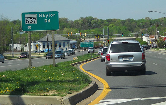
MD 637
· Naylor Rd
0.61 mi.; from MD 5 northwest to DC border.
Status: Signed only at the turnoff from MD 5. No bannered signage as to direction, but inventory data is east-west. This would make sense to be perpendicular to the north-south MD 5 in terms of signage directon. A short connector off MD 5. MD 637 provides access for the Naylor Road Metro Station, followed by an at-grade intersection with Suitland Parkway, before entering the District. Sections of MD 637:
|
637
0.0 DC Line0.1 Suitland Pkwy 0.5 MD 637A 0.6 MD 5 |
|
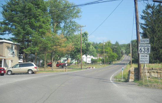
Allegany
Mt. Savage
Eckhart Mines |
MD 638
· Parkersburg Rd
2.34 mi.; from MD 734 (Old National Pike) in Eckhart Mines north to MD 36 west of Mt Savage.
Status: Signed north-south. South of MD 36, MD 638 features a tight turn followed by a one-lane rail overpass. It continues south of Alternate US 40, but there is no signage south to the end at Old National Pike (unsigned MD 743) in Eckhart Mines.
|
638
2.3 MD 361.9 RR Bridge 0.2 US 40 AL 0.0 MD 743 |
|
Allegany
Cumberland
|
MD 639
· Messick Rd, Williams Rd, Willowbrook Rd
2.79 mi.; from I-68 south to MD 51.
Status: Unsigned. Extended in 2008 all the way south to MD 51, around the time of the opening of Allegany Health Center. No signage at the last visit, but this may change soon. Part of Williams Rd adjacent to MD 639 was once part of MD 52.
Sections of MD 639: |
|