|
| Routes: Interstates US Routes State Routes: | Home |
| Routes 640-659 (620-639) Prev (660-679) Next |
Quick Links: Marked Unmarked
Decommissioned |
|
Somerset
Princess Anne
|
MD 640
· Revells Neck Rd.
0.58 mi.; from US 13 west to entrance of Eastern Correctional Institution
Marked east-west. |
640
0.0 Prison Entr.0.6 US 13 |
|
Frederick
Urbana
|
MD 640
· was Thurston Rd.
2.49 mi.; from MD 80 at Urbana to Bennett Creek
Status: Decommissioned 1955; transferred to Frederick County maintenance. (SRC Min. 09-14-1955), number later recycled. |
|
|
Frederick
Johnsville
|
MD 641
· was Middleburg Rd, Simpsons Mill Rd
2.24 mi.; from Carroll-Frederick county line south to MD 75.
Status: Decommissioned 1955; transferred to Frederick County maintenance. (SRC Min. 09-14-1955) In 1948, consisted of two pieces with a gap in the middle. Was unified sometime prior to being dumped in 1955. |
|
|
Anne Arundel
Greenland Beach
|
MD 642
· Greenland Beach Rd
0.08 mi.; from MD 173 east to end of state maintenance.
Status: Unsigned, associated with MD 173. An old bridge approach perhaps? Serves a marina/restaurant next to the Stony Creek drawbridge on MD 173. |
|
|
Baltimore
Arbutus
|
MD 643
· was Sulphur Spring Rd.
0.58 mi.; from Link Avenue to end SHA Maint east of US 1.
Status: Decommissioned; transferred to Baltimore County maintenance. Added in 1940 due to construction of Southwestern Blvd (US 1). Also served as grade elimination for what is today the Amtrak corridor. Route 643-645 are associated with railroad grade eliminations. |
|
|
Baltimore
Arbutus
|
MD 644
· Francis Ave, Tom Day Blvd
2 sections
Status: Unsigned. Added in 1940 due to construction of Southwestern Blvd (US 1). Consists mostly of bridge over Amtrak and Southwestern Blvd. (US 1). Sections of MD 644: |
|
|
Anne Arundel
Harmans
|
MD 645
4 sections, 2 active.
Status: MD 645B, 645D Unsigned.; MD 645A decommissioned 1986; transferred to Anne Arundel County maintenance (SRC Min. 02-21-1986, Agreememt 11-08-1985).; MD 645C decommissioned 1983; transferred to Anne Arundel County maintenance (SRC Min. 01-28-1983, Agreememt 11-15-1982). Sections of MD 645: |
|
|
Harford
Ady
Prospect |
MD 646
· Prospect Rd.
3.31 mi.; from MD 543 northeast to MD 136.
Marked north-south on mainline, but as 'east' on directional signs on MD 543. |
646
0.0 MD 5433.3 MD 136 |
|
Howard
Anne Arundel
|
MD 647
· was Whiskey Bottom Rd
near B&O Railroad bridge near Laurel Park.
Status: Decommissioned; transferred to Anne Arundel/Howard County maintenance. Another railroad grade crossing elimination. MD 647 was gone from maps by 1955. |
|
|
Baltimore City
Westport
Baltimore
English Consul
Baltimore Highlands Anne Arundel
Pumphrey
Linthicum Ferndale Glen Burnie Pasadena Severna Park Arnold Winchester |
MD 648
· Annapolis Rd, Old Annapolis Rd, Baltimore-Annapolis Blvd.
11 sections, 9 active; from MD 450 at east end of Naval Academy bridge north to end of maintenance at ramp from I-95 westbound to MD 295 northbound, Westport.
Status: Mainline sections signed north-south, associated with MD 2. MD 648B and 648C decommissioned 1983 (SRC Min. 01-28-1983, Effective 07-01-1955) Associated Secret-Obscure Routes: 915 Carleton Jones, in his book Streetwise Baltimore, noted that the old Annapolis Boulevard "had been chopped up into so many segments… [that] anyone who attempts to reach [Annapolis] from Baltimore over this route had better bring along a sextant and overnight gear." As such it is the quintessential old Maryland alignment, darting back and forth from the view of the arrow-straight MD 2. It's also the bane of out-of-staters, whose signed state routes actually go someplace, and would think Maryland routes do similar. A signed route here is no guarantee against a dead end. There's no access across US 50-301 on 648, but still a single ramp off westbound to north on 648, a reminder of 50-301's non-freeway past. As new sections came online, the old became parts of 648. In turn, two pieces have been cut off by the construction of MD 100, becoming MD 915. MD 100 overpasses with no direct access. MD 648 annexed the entirety of MD 706 (Waterford Rd) to maintain the connection with MD 177. Once there, MD 648 has a de-facto concurrency with MD 177 west to the next alignment, which is the same leading north through Glen Burnie and up into Baltimore. North of Glen Burnie, 648 was the original route of US 301 north into Baltimore. From 648's current end in Westport, 301 headed northwest on Monroe St to end at US 1. The only 648 shield to be found in Baltimore City is to be found on BW Parkway signage. MD 648's current intersection with Business MD 3 in Glen Burnie was the location for Maryland's first traffic signal. Sections of MD 648: Mainline order (north to south) is E, H, D, F, A. Original path was E, (915), H, AA, D, C, B, A. |
648E
11.1 Ramp10.9 Monroe St 10.3 Russell St 10.3 MD 295 10.3 Waterview Ave 9.4 Patapsco Ave 9.3 BA-BC Line 7.8 AA-BA Line 7.5 MD 168 7.0 MD 170 6.4 I-695 5 6.3 MD 169 5.1 Hammonds Ferry 4.3 I-97 16 3.8 MD 176 3.3 MD 3 Business 3.1 MD 2 1.8 MD 10 - 1.8 MD 648G 1.3 Marley Neck Rd 0.0 Jumpers Hole Rd 0.0 MD 177 648H
3.5 Solley Rd3.5 MD 177 2.4 MD 915 1.4 Magothy Br Rd 0.2 MD 648AA 0.0 MD 2 648D
4.2 MD 23.9 Admiral Rd 3.8 Admiral Rd 2.1 Jones Sta Rd 1.9 MD 2 (s/b) 0.0 MD 2 648F
0.6 MD 20.0 US 50-301 (w/b) No Access Across US 50-301 648A
2.1 Road End0.9 MD 179 0.5 MD 672 0.1 MD 648AB 0.0 MD 450 |
|
Charles
Port Tobacco
|
MD 649
· (unknown)
0.28 mi.; from MD 6 at Port Tobacco to MD 6.
Status: Decommissioned 1956; transferred to Charles County maintenance. (SRC Min. 12-13-1955, Agreement 11-29-1955, Effective 07-01-1956) A loop near Port Tobacco off MD 6, probable old alignment |
|
|
Montgomery
Etchison
Unity Sunshine Brighton Brinklow Ashton Colesville White Oak Prince George's
Adelphi
Langley Park Montgomery
Takoma Park
|
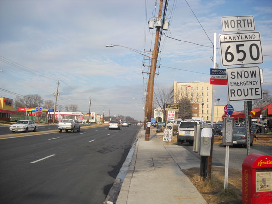
MD 650
· New Hampshire Ave, Damascus Rd
25.89 mi.; from DC line at Takoma Park north to MD 108, Etchison.
Status: Signed north-south. Associated Secret-Obscure Routes: 897 A main route north of DC, MD 650 has its original section south of US 29, which traversed New Hampshire Avenue from White Oak north to Ashton, before taking a right onto current MD 108. North of Ashton was MD 116 up to Brighton Dam Rd. MD 650 annexed both the old path of 29 and 116. It was extended 2.8 miles from Brighton Dam Rd to MD 97 in 1973, with the final extension to MD 108 added in 1976. The name change occurs at MD 97.
|
650
25.8 MD 10820.6 MD 97 17.6 Brighton Dam Rd 14.3 MD 108 11.9 MD 198A 11.8 MD 198 11.8 Norbeck Rd 9.2 MD 200- 8.3 Randolph Rd 6.0 US 29 - 5.7 Lockwood Dr 4.3 Powder Mill Rd 4.0 I-495 28 3.1 PG-MO Line 1.8 MD 193 1.8 MO-PG Line 0.8 PG-MO Line 0.8 MD 410 0.0 DC Line |
|
Harford
Harkins
|
MD 651
· was St Clair Bridge Rd
0.09 mi.; from MD 165 to North Bend Rd.
Status: Decommissioned 1953; transferred to Harford County maintenance. (SRC Min. 05-20-1953, Effective 07-01-1953) MD 651 was a short spur off MD 165. Not far across and slightly offset was a similarly short MD 163. |
|
|
Anne Arundel
Harmans
|
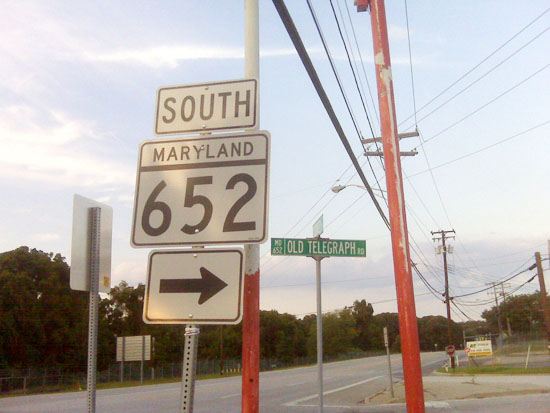
MD 652
· Old Telegraph Rd
0.69 mi.; from road end at MD 100 north to MD 176.
Status: Signed at turn from MD 176. Associated with MD 170 MD 652, with the completion of Route 100, is on the endangered list. Its usefulness is now limited to access to Queenstown Rd, which does have a bridge over 100. Though it seems nowhere around now, this is the old alignment of MD 170 before land was taken for Friendship (later BWI) Airport. Its junction with 170 was lost under the MD 100 interchange. The old road continues inside the airport fence to the old Friendship Cemetery. Also lost was part of the WB&A Railway. Should Anne Arundel need to swap mileage, Route 652 would likely face the chopping block.
|
652
0.7 MD 1760.2 Queenstown Rd 0.0 Road End |
|
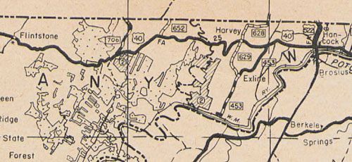
Allegany
Piney Grove
|
MD 652
· was Orleans Rd
from US 40 (now Scenic 40) to PA Line.
Status: Decommissioned sometime after 1938. There is no record of it, but likely 1956 like other nearby routes. Orleans Rd now extends south to an interchange with I-68. According to HTDS, "no record of this road being transferred back to County" (SHA Min 06-30-1938). Began a cluster of Allegany routes 652-658 except 653.
|
|
|
Montgomery
Silver Spring
|
MD 653
· was 16th St
old number for MD 390 from DC line at Blair Portal north to MD 410.
Status: Entire route became part of MD 390 by 1956. Number not reassigned.
|
|
|
Allegany
Frostburg
|
MD 654 (1939-1956)
· was Welsh Hill Rd
0.70 mi.; from MD 36 to Corp Limits Frostburg.
Status: Decommissioned 1956; transferred to Allegany County maintenance. (SRC Min. 11-10-1955, Effective 07-01-1956) The mileage at the time of decommissioning was 0.49 miles, less than the 0.70 stated at the time of its addition. |
|
|
Montgomery
|
MD 655
· Old MD 28
9 active sections.
Status: Unsigned, associated with MD 28. Current MD 655 came about in 1985 when MD 28 was widened and realigned. Sections of MD 655: |
|
|
Allegany
Klondike
|
MD 655 (1939-1956)
· was Klondike Rd
1.40 mi.; MD 36 to Klondike.
Status: Decommissioned 1956; transferred to Allegany County maintenance. (SRC Min. 11-10-1955, Effective 07-01-1956) |
|
|
Queen Anne's
Queenstown
|
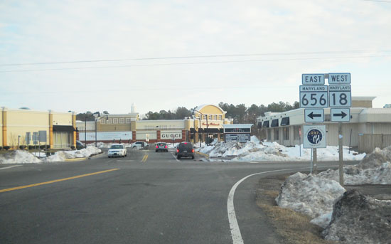
MD 656
· Friels Rd
0.70 mi.; from MD 18 (18S) at Outlet Center Dr east to MD 456.
Status: Signed east-west. Associated with MD 456. Number is derived from MD 456. Runs around the back of the outlet center near the US 50-301 split. MD 18S is just the letter suffix, not intended to mean 'south'. MD 656 was the first known instance of a number being used thrice.
|
656
0.0 MD 180.7 MD 456 |
|
Talbot
Easton
|
MD 656 (1979)
· was Black Dog Alley
0.70 mi.; from US 50 east to Cordova Rd (MD 309).
Status: Became part of MD 309 in 1979, number later recycled. (SRC Min. 11-10-1955, Effective 07-01-1956). Despite the name, it is a standard width 2-lane road. It was added to create a right-angle intersection with US 50 for MD 309, which had been more of a Y intersection. MD 309 south from this route to US 50 was transferred back to the county at the same time, a distance of 0.14 miles. It was later extended across US 50 to connect with an extended 662. |
|
|
Allegany
Lonaconing
|
MD 656 (1938-1956)
· was Watercliffe Rd
0.25 mi.; loop off MD 36 "in Lonaconing".
Status: Decommissioned 1956, transferred to Lonaconing municipal maintenance (SRC Min. 11-10-1955, Effective 07-01-1956). Added in 1939, dropped in 1956 in the sweep of minor routes during the 12 Year Program. Was part of a cluster of routes near MD 36. |
|
|
Allegany
Lonaconing
|
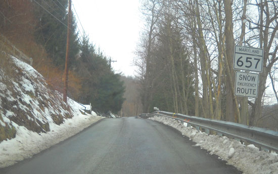
MD 657
· Skids Hill Rd, Douglas Ave [Lonaconing]
1.82 mi.; from MD 36 northwest to Allegany-Garrett county line.
Status: Decomissioned 2011, transferred to Allegany County maintenance. Prior to being dropped, 657 was the longest signed Maryland route not to have line striping. Only 657 signage occurs westbound when exiting the limits of Lonaconing. Ending at same point near the Allegany-Garrett border, this county line was one of the last to experience an adjustment. The portion that was within the town limits of Lonaconing was posted with an unusually low 15 mph limit.
|
657
1.8 ESM1.8 AL-GA Line 0.0 MD 36 |
|
Allegany
La Vale
|
MD 658
· Vocke Rd
0.61 mi.; from MD 53 northeast to Alt US 40
Status: Unmarked. NHS: Possibly, since it links an NHS corridor (MD 53) to I-68, and is necessary to complete movements onto I-68. Only clue to Vocke's state route status is the SHA standard "Snow Emergency Route" signs which stand alone. The SHA facility along the road is also a good clue. |
658
0.6 US 40 Alt0.5 MD 49 0.5 I-68 40 0.4 MD 949 0.0 MD 53 |
|
Montgomery
Rockville
|
MD 659
· was Stonestreet Ave
0.20 mi.; from Old Baltimore Ave (former MD 676) to road end.
Status: Decommissioned 1959. Transferred to Rockville municipal maintenance. (SRC Min. 07-28-1959, effective same date) Nowadays this road has ramp access to and from Veirs Mill Rd (MD 28, 586). This route was dropped at the same time as the adjacent MD 676. |
|


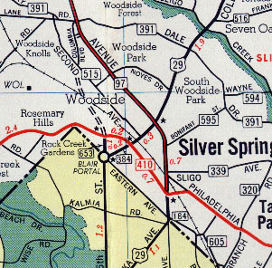
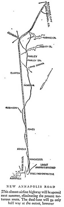 1936 map of the "New Annapolis Road", later to be named Ritchie Hwy (MD 2), the old route to become MD 648.