
|
| Routes: Interstates US Routes State Routes: | Home |
| Routes 660-679 (640-659) Prev (680-699) Next |
Quick Links: Marked Unmarked
Decommissioned |
|
Montgomery
Rockville
|
MD 660
· Dodge St
~250 ft.; from MD 355 north to MD 28
-
Unmarked. A small section between 355 and 28, which meet at an acute angle. |
|
|
Kent
Pomona
Quaker Neck Ldg |
MD 661
· was Quaker Neck Landing Rd
from MD 289 south to road end.
No longer assigned (decommissioned 1999). Dropped around 1999 along with neighboring MD 664.
|
|
|
Queen Annes
Wye Mills
Talbot
Wye Mills
Skipton Easton |
MD 662
· (Old) Wye Mills Rd, Old Skipton Rd, Longwoods Rd, Centreville Rd
from MD 322 near Easton north to US 50, Wye Mills in 4 sections
Marked, associated with US 50. Would have been part of US 213 (MD 404 north of Wye Mills), then US 50 after 1949. Passes the site of the Wye Oak, which was estimated to have lived 400+ years before being felled by lightning in 2004.
Sections of MD 662: |
662A
0.1 US 50 (E/B only)0.0 MD 662 662
4.4 US 504.4 MD 662A 3.1 MD 213 0.0 US 50 662B
2.1 US 500.0 US 50 662C
4.4 US 500.0 MD 322 |
|
Kent
Kennedyville
|
MD 662
· was Turners Creek Rd
old number for northern part of MD 448
No longer assigned (decommissioned), became part of MD 448. MD 448 subsequently decommissioned. MD 448 was lengthened sometime before 1948, taking over this route. MD 448 was later itself dropped. |
|
|
Wicomico
Salisbury
|
MD 663
· was Camden Ave
from Bus US 13 north to Bus US 50, Salisbury.
No longer assigned (decommissioned). A former alignment of US 13, having been twice bypassed. |
|
|
Kent
|
MD 664
· was Wilkins Lane
from MD 289 southeast to road end.
No longer assigned (decommissioned 1999). ................... |
|
|
Anne Arundel
Annapolis
|
MD 665
· Aris T. Allen Blvd
2.68 mi.; from US 50-301 east to end of state maintenance at Bywater Rd.
Marked east-west. Limited Access: from US 50-301 east to traffic light at Chinquapin Round Rd. MD 665 originally consisted of Forest Drive to the east of the current route. Limited access section completed in 1991, and original route dropped from state maintenance. There was a rumor that this route was to be designated I-197, but it would have been part of US 50-301 to the east. The designation of I-197 never happened anyway; US 50-301 is now designated I-595 on an official, but unsigned basis. ................... Sections of MD 665: |
665
0.0 - US 50-301 220.9 - Riva Rd 1.6 - MD 2 1.9 MD 665A 2.0 MD 665B 2.7 MD 665C |
|
Montgomery
Kensington
|
MD 666
· was Saint Paul St, Armory Ave, Howard Ave
loop east off MD 185 (then MD 193).
No longer assigned (decommissioned), associated with MD 185 (then MD 193).
MD 666 came about as a result of a railroad grade replacement, and would have been part of MD 193 prior to that. It's in two pieces on either side of the old crossing. The route was likely dropped in the late 1950s. |
|
|
Somerset
Westover
Kingston Hudsons Cor. Marion Hopewell Crisfield |
MD 667
· Rehobeth Rd, Hudson Corner Rd, Crisfield-Marion Rd, Old State Rd
17.61 mi.; from eastern limit of Crisfield northeast to US 13 near Westover.
Marked, unsure of cardinal directions. Associated with MD 413 MD 667 comprises the former route of MD 413. The 1948 official map shows the new route complete southwest of Marion, and the rest was complete by 1950. The section of 667 north from Hudson's Corner was shifted eastward along old MD 406 to US 13. |
667
17.6 US 135.8 MD 413 2.8 MD 413 0.0 BSM |
|
Carroll
Wentz
|
MD 668
· Boswells Dr
0.15 mi.; from Harvey Yingling Rd north to road end
Unmarked. This route is near MD 30, but much farther north than the old sections of mainline MD 30. |
|
|
Baltimore
Fowblesburg
Boring Woodensburg |
MD 668
· was Old Hanover Pike
2 main sections
No longer assigned (decommissioned), number re-used further north. Assocated with MD 30. There were two sections of this route, both to the east of current MD 30. They parallel the Western Maryland railroad line. The southern one is now in 2 parts, and was a railroad grade replacement. It closely parallels current MD 30 just north of Reisterstown, and remained in state maintenace longer than the other section. The northern section was more winding, with at least 2 grade crossings. It returns to MD 30 near the MD 91 junction in the hamlet of Fowblesburg. |
|
|
Garrett
Grantsville
|
MD 669
· Springs Rd.
1.69 mi.; from US 40 Alternate north to Pennsylvania border.
Marked north-south. Originally designated MD 417 until 1963. Changed to match adjacent PA 669, assigned April 1, 1963.
|
669
1.7 PA 6691.7 PA Line 0.0 US 40 Alt |
|
Washington
Boonsboro
|
MD 669
· was Benevola Church Rd.
from MD 66 west to end of state maintenance.
No longer assigned (decommissioned), number recycled for current MD 669.
|
|
|
Wicomico
Hebron
|
MD 670
· Lillian St
1.48 mi.; from MD 347 in Hebron east to US 50.
Marked, unsure of cardinal directions. This route may have no directional signs, like some others in this part of Wicomico County.
|
670
0.0 MD 3471.5 US 50 |
|
Worcester
Girdletree
Bayview |
MD 671
· was Taylor Landing Rd
from MD 12 east to end of state maintenance.
No longer assigned (decommissioned).
|
|
|
Anne Arundel
Annapolis
|
MD 672
· Greenbury Point Rd
0.19 mi.; from MD 648 east to end of state maintenance.
Marked east-west. Picked up into state maintenance as early as 1937, MD 672 is one of the shortest signed routes. It leads to the Naval Academy Golf Club, and the former site of a gigantic array of naval radio towers that the locals actually wanted to preserve. |
672
0.0 MD 6480.2 ESM |
|
Somerset
Westover
|
MD 673
· Sam Barnes Rd
0.53 mi.; from MD 413 east to US 13.
Marked east-west, officially 673A. This route is a shortcut between US 13 and MD 413 just south of the split. It dates back at least to 1948. |
673
0.0 MD 4130.5 US 13 |
|
Somerset
Costen
|
MD 673
· was Costen Rd
loop east off US 13.
No longer assigned (decommissioned). This former section was an old part of US 13. It was southeast of the still extant section of 673. |
|
|
Kent
Rock Hall
|
MD 674
· Sharp St
1.16 mi.; from beginning of state maintenance Grays Inn Creek east to MD 20.
Marked east-west. Another route that defies the SHA's axe. MD 674 may have been an old routing of MD 20. |
674
0.0 BSM1.2 MD 20 |
|
Wicomico
Delmar
Salisbury Somerset
Princess Anne
|
MD 675
· Bi-State Blvd, Somerset Ave
4 total sections (2 mainline)
Marked north-south, Delmar section designated May 15, 1968 (formerly US 13 Alt.) associated with US 13. Bi-State Blvd is the name for 675 in Wicomico Blvd, north of Salisbury, and Somerset Blvd in Somerset County. MD 675 consists of more former sections of US 13. Sections of MD 675: |
675(b)
2.1 DE RD 132.1 DE Line 2.1 MD/DE 54 0.0 US 13
675
3.4 US 132.8 MD 529 2.6 MD 822 2.2 MD 362 1.6 MD 918 1.3 MD 388 0.0 MD 675D 675(d)
0.07 MD 675 |
|
Montgomery
Rockville
|
MD 676
· was Baltimore Rd
from current MD 355 east to MD 28.
No longer assigned (decommissioned), associated with MD 28. MD 676 was a railroad grade crossing elimination for MD 28, which once ran along Baltimore Rd. East of the current MD 28, a piece of Baltimore Rd near the Rock Creek bridge is designated MD 898. |
|
|
Anne Arundel
Odenton
|
MD 677
· was Odenton Rd
0.94 mi.; from Piney Orchard Pkwy (former southern end of MD 170) east to MD 175.
No longer assigned (decommissioned 2004). MD 677 originated as another railroad grade elimination. MD 170 once ran south to end at MD 677, but its end was truncated a few blocks back to MD 175. It now seems to run along the back of some shopping centers facing 175. The route was dropped in 2004 although signage may have remained a bit longer. |
677
0.0 Piney Orchard0.9 MD 175 |
|
Carroll
Finksburg
|
MD 678
· was Deer Park Rd
from MD 91 northwest to indeterminate point.
No longer assigned (decommissioned). It's there in 1948 and 1955, likely gone by 1960. Southeast of the formerly designated portion, Deer Park Rd serves as a back way into Baltimore County and onto I-795.
|
|
|
|
MD 679
not assigned
|
|


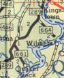 MD 661 and 664 shown on the 1955 SRC official map.
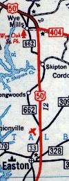 MD 662 shown on a 1958 map. MD 33 on the map is now MD 322.


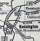 MD 666 shown on a 1956 map. MD 193 on the map is now MD 185.


 MD 669 as MD 417, 1958.
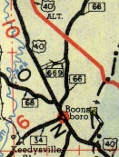 MD 669, 1948. Note that the route ended
about halfway between MD 66 and US 40. US 40 main and US 40 alternate
are now swapped.
MD 669, 1948. Note that the route ended
about halfway between MD 66 and US 40. US 40 main and US 40 alternate
are now swapped.
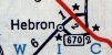 MD 670, 1958. The red line is US 50. Unlike some other short routes, 670 still remains.
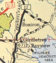 MD 671, 1955.


 MD 678, 1948.