|
| Routes: Interstates US Routes State Routes: | Home |
| Routes 700-719 (680-699) Prev (720-739) Next |
Quick Links: Marked Unmarked
Decommissioned |
|
Baltimore
Middle River
|
MD 700
· Martin Blvd.
1.97 mi.; from US 40 southeast to MD 150.
Marked north-south. MD 700 was built in 1942 to improve wartime access to the Glenn L. Martin Co. aircraft complex in Middle River. Like Eastern and North Point Boulevards (150 & 151, respectively), 700 was a necessity of the war effort. It remains in the same 4 lane dual configuration today. During the war, right after it was built, Martin Blvd was numbered as MD 493, the number previously given to the eastern portion of Orems Rd. By 1948, it was given its current number 700. ................... |
700
2.0 - US 401.8 Kelso Dr. 1.2 Compass Rd. 0.5 Middle River Rd. 0.2 Riverton Rd. 0.0 - MD 150 |
|
Kent
Millington
|
MD 701
· Howard Johnson Rd.
0.71 mi.; parallels US 301 to east near MD 291.
Unmarked. A frontage road off the east side of US 301, offering access to a Howard Johnson's motel. Runs parallel to the east of 301. |
|
|
Montgomery
Laytonsville
|
MD 701
· was Sundown Rd.
from MD 108 east to end of state maintenance ~2 mi.
No longer assigned (decommissioned). Route 701 ran from the main intersection in Laytonsville eastward to an undetermined point about 2/3 of the way to Mt. Zion Rd. It shows up on all 1962 and earlier maps. Laytonsville is incorporated, so Sundown Rd. probably has another name within town limits. |
|
|
Baltimore
Essex
|
MD 702
· Southeast Blvd.
4.13 mi.; from I-695 south to Back River Neck Rd.
Status: Marked north-south. Limited Access: From I-695 to traffic signal at Old Eastern Avenue (formerly MD 600) Truck Restrictions: No trucks over 5 tons south of Old Eastern Avenue (use Back River Neck Road) The Southeast Freeway was originally planned to be the mainline Baltimore Beltway, I-695. Several proposals existed in the late sixties for extending the Beltway south and east past US 40 to an eventual 'Outer Harbor Crossing' (Key Bridge) or even across the Bay to MD 21 in Tolchester Beach, a second Bay Bridge. The first plan was to extend the Beltway down Back River Neck, cross Back River near Rocky Point ending up near what is now Beltway Exit 42, and on to the OHC. A segment was completed from US 40 to MD 150 (Eastern Blvd.) around 1973. When the proposed alignment of I-695 was shifted westward down the Patapsco River Neck, it left 2 miles of interstate-standard freeway off the new mainline running all the way to Old Eastern Avenue, which was designated MD 702. Southward extension of 702 as a fully limited access freeway was officially scrapped in July, 1978. Plans remained on the books for a partial limited access highway, with traffic lights at selected cross streets. In the late eighties, these plans would be approved. MD 702 was extended in 1990 using the original alignment cleared for the Beltway, to enhance local access to the Back River Neck peninsula and relieve congestion on Back River Neck Road. In deference to community concerns about noise, trucks over 5 tons are prohibited on the e xtended portion. The speed limit was only 40, raised in 2000 to 45, even through the open undeveloped area south of Middleborough with 4 lanes divided and full shoulders. State maintenance continues ~1000 feet further down Back River Neck Rd., south to Pottery Farm Rd., although there is no signage until BRN splits near Turkey Point Rd. |
702
0.0 - I-695 361.7 - MD 150 2.0 Old Eastern 3.1 Middleborough 3.4 Hyde Park 4.0 Turkey Pt 4.1 BSM |
|
Montgomery
Bethesda
|
MD 702
· was Jones Bridge Rd.
from MD 355 east ~0.5 mi. near Bethesda Naval Hospital .
Decommissioned. According to SRC maps, state maintenance extended half a mile or so from Rockville Pike (now MD 355), along the stretch of road forming the southern boundary of the hospital. The route was dumped in time for the number to be used for its present-day incarnation above. |
|
|
Worcester
Klej Grange
|
MD 703
· Klej Grange Rd
0.08 mi.; west off MD 366
Unmarked. ................... |
|
|
Prince George's
Bowie
|
MD 703
· was Race Track Rd.
from MD 450 north to old Bowie Race Course.
No longer assigned (decommissioned c. 1975). Access road to the old Bowie race course. State maintenance extended from MD 450 to just past the sharp left curve approaching the track (this curve has been removed). The facility is still in use for the time being, but could make way for residential development in the near future. |
|
|
Prince George's
Seat Pleasant
Glenarden |
MD 704
· Martin Luther King Jr. Hwy.
6.75 mi.; from DC Line in Seat Pleasant east to MD 450.
Marked east-west. Built on the former right-of-way of the Washington, Baltimore & Annapolis railroad. Originally named George N. Palmer Highway. I know neither who Palmer was nor when the name was changed to honor MLK. Have to get back to you on this. It is strange to have a highway named for one person and then renamed for another. According to the 1961 Maryland Official Highway Map, was signed Temp US 50 while John Hanson Highway was under construction. The interchange with US 50 is a full cloverleaf at a very oblique angle. |
704
0.0 DC Line3.0 - MD 202 5.2 US 50 8 6.8 MD 450 |
|
Prince George's
Croom
|
MD 705
· was Croom Airport Rd.
from MD 382 east to end of road near Croom Airport
No longer assigned (decommissioned 1956). Access road for small Croom airfield in southeastern Prince George's Co. The route was still there in 1953, but gone by 1961. A casualty of the consolidation and dropping of minor routes during the 12 Year Program. |
|
|
Anne Arundel
Pasadena
|
MD 706
· was Waterford Rd.
between Mountain Rd. (MD 177) and Old B&A Blvd. (MD 648).
No longer assigned (decommissioned 1971), entire route now part of MD 648. MD 706 existed until limited-access MD 100 was built in the early 1970s, necessitating closure of Baltimore-Annapolis Blvd. in this area. MD 648 was shifted over to Waterford Rd. The closed portions of B&A Blvd. on both sides of the new 100 became unsigned MD 915. The latest appearance of 706 was in the official Maryland map from 1970. |
|
|
Worcester
West Ocean City
|
MD 707
· Grays Corner Rd., Old Bridge Rd.
1.87 mi. [broken] (a), 0.79 mi. (b) 2.20 mi.; from US 50 at MD 452 east in 3 pieces to MD 611.
Marked east-west. Route 707 was once the mainline US 213 to Ocean City. A welcome sight, as the journey to OC is almost over, but watch for the backups-on 50 that is. Rather well kept for just a frontage road. It's two lanes for the entire route. It appears in three pieces, the first two being Grays Corner Road east from Friendship Road (MD 452) running along the north side of 50 for about 2.5 miles. A 1/4 mile section east of Riddle Lane east was closed in the mid-2000s and appears to be a bike trail. The 0.76 mile eastern portion of this severed route was re-designated MD 707D. There's a break in the route as 50 crosses Herring Creek in the same corridor, then reappears as Old Bridge Road, this time running south of 50 and a little farther away. Before MD 707 was rolled back to MD 611, it traveled a straight line to its end at the shore of the inlet, where the 'old bridge' was. On the Ocean City side, the bridge connected with Worcester St. The 707 bridge was taken out between 1949 and 1953. I remember seeing warnings about the bridge pilings on nautical charts, are remains visible? |
707B
0.0 road end0.1 MD 452 1.4 MD 589 3.0 US 50 3.3 road end
707A
0.0 US 500.8 MD 611 |
|
Worcester
Ocean City
|
MD 708
· was 1st St.?
between MD 528 and bay shore.
No longer assigned (decommissioned). Was somewhere on the bay side, a block or two west off 528. Have to check the maps
at the State Archives again for exact location of 708. Trust me, it was there!
|
|
|
Allegany
Piney Grove
|
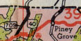
MD 709
· was Green Ridge Rd.
from US 40 Scenic north to PA line.
No longer assigned (decommissioned). Can't say much until I go out there. Dropped during the 12 Year Program. Like many short routes, the 1953 map shows it, but on the 1961 map, it's gone.
|
|
|
Anne Arundel
Glen Burnie
|
MD 710
· East Ordnance Rd
2.16 mi.; from MD 2 in Glen Burnie northeast to MD 173 at Baltimore city line.
Marked east-west. ................... Before MD 10 was constructed (710 existed well before 10), 710 went straight west along what is now Old Ordnance Rd to MD 2 instead of its more southerly route today. Part of the old road is now unmarked MD 711. |
710
2.2 MD 1732.2 AA-BC Line 0.6 MD 10 0.0 MD 2 |
|
Anne Arundel
Glen Burnie
|
MD 711
· Arundel Corp Rd
0.51 mi.; east off Ritchie Hwy (MD 2).
Unmarked. Consists of a part of old MD 710 before construction of MD 10 east of this area. The southeast ramps from I-695 Exit 3 end up on this section of MD 711; this was the southern terminus of the original Beltway. On the other side of MD 10, Blades Lane west off Ordnance Road (MD 710) was also a part of MD 711. |
|
|
St. Mary's
Hermanville
|
MD 712
· Forest Park Rd
1.11 mi.; from MD 235 north to gate of Patuxent NAS.
Marked north-south. ................... |
712
1.1 PAX NAS Gate0.0 MD 235 |
|
Anne Arundel
Hanover
Harmans |
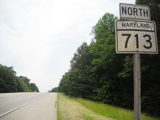
MD 713
· Rockenbach Rd, Ridge Rd, Arundel Mills Blvd
3.01 mi.; from entrance of Ft. Meade north to MD 176.
Marked north-south. MD 713's northern end skirts the edge of Arundel Mills Mall, which, along with MD 100, made upgrades and a rerouting necessary. The old portions that remained were designated suffixed routes 713B-C-D. With the completion of MD 100, it became the primary connector to 713, and its northern terminus with MD 176 is lessened in importance. The adjacent county maintained portion of Arundel Mills Blvd connects with a new interchange with MD 295; this dumbbell junction is in state maintenance as MD 713F. Rockenbach Rd is the name mostly used within Fort Meade, but also for the southern end of MD 713 from MD 175 south to the gate. Sections of MD 713:
|
713
3.0 MD 1762.8 MD 100 10 0.0 BSM |
|
Prince George's
Morningside
|
MD 714
·
across from Westphalia Rd intersection with MD 4 south to MD 337 near Andrews AFB
No longer assigned (decommissioned). ................... |
|
|
Harford
Aberdeen
|
MD 715
· Short Lane
1.19 mi.; from US 40 southeast to gates of Aberdeen Proving Ground.
Marked north-south. NHS: entire length. ................... |
715
1.2 US 400.0 APG Gate |
|
Prince George's
Landover
|
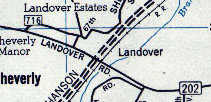
MD 716
· was Old Landover Road
parts of old MD 202 near US 50.
No longer assigned (decommissioned), was associated with old sections of MD 202. ...................
|
|
|
Prince George's
Upper Marlboro
|
MD 717
· Water St
0.33 mi.; from MD 725 south to MD 4 interchange.
Unmarked. ................... |
|
|
Baltimore
Edgemere
Sparrows Point |
MD 718
· was Sparrows Point Rd
from MD 151 (Sparrows Point Blvd) northeast to North Point Rd (former MD 20).
No longer assigned (decommissioned 1999). Formerly MD 151 until bypassed via Sparrows Point Blvd sometime around WWII, creating MD 718. Route dropped in 1999 along with the adjacent MD 20 in exchange for bringing Merritt Blvd (MD 157) into state maintenance. |
|
|
Garrett
Grantsville
|
MD 719
· was Casselman Rd
off US 40 at Casselman River State Park
No longer assigned (decommissioned). Appears in a 1955 SRC document. Probably dropped not long thereafter. |
|