
|
| Routes: Interstates US Routes State Routes: | Home |
| Routes 740-759 (720-739) Prev (760-779) Next |
Quick Links: Marked Unmarked
Decommissioned |
|
Carroll
Westminster
|
MD 740
· was Sullivan Rd, Wimert Ave, Hahn Rd
2 sections either side of MD 140
Status: Decommissioned 1985; transferred to Carroll County maintenance. (SHA Min. 08-06-1985) Number derived from MD 140. Probably never signed. Wimert Ave serves a diner and the St John's church/school. Sullivan Rd, an Exxon station and a Roy Rogers. (Besides the Maryland House on I-95, the last Roy's in Greater Baltimore) The numbers in this section start out in Western Maryland, later seeming to ping-pong around the state. One thing in commmon here, lack of signage. Only 3 of the 20 are signed. Sections of MD 740: |
|
|
Washington
Wilson
|
MD 740
· (unknown)
0.27 mi.; US 40 at Wilson to road end
Status: Decommissioned 1955; transferred to Washington County maintenance. (SRC Min. 05-06-1955, Effective 07-01-1955) Like MD 739, an unknown route in Washington County near Wilson. Possibly Stone Bridge Rd, the eastern approach to the old stone bridge. But 1/4 mile or so seems a bit long from my visit there. |
|
|
Allegany
Benevola
|
MD 741
· (no name)
0.06 mi.; from US 40 Alt near Thomas Dr/Jeswood Dr south to road end.
Status: Unmarked. Looks like the removal of a dead man's curve on Alt US 40. |
|
|
Garrett
Friendsville
|
MD 742
· First Ave, Maple St [Friendsville]
0.93 mi.; from MD 42 south of Friendsville north to MD 42/I-68 ramps west of same.
Status: Unmarked, associated with MD 42. Runs north off MD 42 to Friendsville, thus westward back to 42. No access to I-68 on the south, but the north end leads right into a westbound on-ramp. |
|
|
Allegany
Frostburg
|
MD 743
· Old National Pike
1.00 mi.; from MD 36 east to US 40 Alt.
Status: Unmarked. Haven't travelled on it yet to confirm (forgot it was there on my Jan 2010 trip), but have been past both ends, with no markers evident. Hopefully I would have noticed a 743 marker. Not likely there would be any surprises somewhere along it. Length is exactly one mile. Though not shown on some maps, MD 638 extends south from Alt US 40 to MD 743, with no signage. |
|
|
Dorchester
Cambridge
|
MD 744
· was Dorchester Ave
0.59 mi.; from MD 343 (then MD 16) north to Maryland Ave (then MD 343).
Status: Decommissioned 1955; transferred to Cambridge municipal maintenance. (SRC Min. 12-21-1955)
|
|
|
Washington
|
MD 745
· (unknown)
Status: Decommissioned. Unknown road in Washington County. |
|
|
Baltimore
Ruxton
|
MD 746
· Old Falls Rd
0.13 mi.; from MD 25 to road end at Light Rail.
Status: Unmarked, officially 746A, associated with MD 25. From Western Maryland, we move now to just north of the Baltimore City/County line. Serves a Light Rail stop parking lot. |
|
|
Washington
|
MD 747
· (unknown)
Status: Decommissioned. Unknown road in Washington County. |
|
|
Washington
|
MD 748
· (unknown)
Status: Decommissioned. Unknown road in Washington County. |
|
|
Calvert
Solomons Island
|
MD 749
· was Williams St [Solomons Island], Carls Way, Farren Ave
0.34 mi.; from MD 2 back to MD 2.
Status: Decommissioned 1956-57; transferred to Calvert County maintenance. (SHA Min. 07-01-1956, Effective 07-01-1957) Re-established; transferred to SRC maintenance. (SHA Min. 09-25-1963, Effective 10-01-1963) Decommissioned circa 1998; transferred back to Calvert County maintenance. Unusual for a road to have two stints as the same route. Formed part of the southern terminus of 80 mile long MD 2. Shown as Memorial Drive, Charles St in the RTDS data. Charles St is the name for MD 2 today. Mileage of the loop of these streets match.
|
|
|
Dorchester
Cambridge
|
MD 750
· (no name)
0.87 mi.; loop north off US 50.
Status: Signed east-west. I thought the name for 750 was Bucktown Rd, but the HLR says none. There's an SHA garage along this route. Going back, this alignment started as MD 344 (before the Choptank Bridge in 1940), US 213 (1940-49), US 50 (until current 50 was built), and MD 750 thereafter. There used to be 8 sections, and they were numbered suffixes 750-1 to 750-8, not lettered as today. |
750
0.0 US 500.9 US 50 |
|
Calvert
Owings
Paris |
MD 751
· was Chesapeake Beach Rd
6.22 mi.; from MD 4 (then MD 416) southeast to MD 260, Paris.
Status: Temporary designation for new construction. Entire route became part of MD 260 in 1955. Built along the old right-of-way of the Chesapeake Beach Railway, closed in 1935. MD 751 was opened in three parts between 1953 and 1955. Once completed, MD 260 was rerouted off Mt Harmony Rd west of Paris onto it. |
|
|
Calvert
|
MD 752
· (no name)
0.15 mi.; from MD 231 just east of Patuxent River Bridge south to road end.
Status: Unmarked. Possible relocation of service road brought about by construction of bridge. |
|
|
Harford
Street
|
MD 753
· was Street Rd
1.04 mi.; from Old Pylesville Rd (old 165, then 765) south to end of state maintenance at Highland Rd
Status: Decommissioned 1977; transferred to Harford County maintenance. (SRC Min. 11-22-1977, Effective 05-27-1977) MD 753 and 754 served the old Ma & Pa railroad town of Street. This one came into Street from the north. |
|
|
Harford
Street
|
MD 754
· was Highland Rd
0.61 mi.; from MD 543 west to end of state maintenance west of Heaps School Rd.
Status: Decommissioned 1977; transferred to Harford County maintenance. (SRC Min. 11-22-1977, Effective 05-27-1977) MD 754 entered Street from the east. The end of state maintenance may have coincided with the old Ma & Pa Railroad crossing. |
|
|
Harford
Edgewood
|
MD 755
· Edgewood Rd
1.79 mi.; from APG gate north to US 40.
Status: Signed north-south only on MD 24 and US 40, associated with MD 24. No markers on the route itself remain; the portion between US 40 and MD 24 is too short for one. Not so south to the now apparently closed entry gate to APG Edgewood, yet still no 755 signage. Several roadside businesses, gas stations and even an American Legion hall now lie boarded up and/or abandoned, as most base traffic now passes them by on MD 24. I wouldn't be surprised if 755 is decommissioned altogether, and the 24/40 connector portion made a suffixed section of MD 24. MD 755 was also shown on SHA grid maps for what is now MD 924. Don't remember any 755 signage there, though. The current part was MD 408 and the MD 24 before becoming 755. Once extended north at least to MD 7; this piece features a one-lane railroad underpass. |
755
1.8 US 401.6 MD 24 0.0 APG Gate |
|
Worcester
Pocomoke City
|
MD 756
· Old Snow Hill Rd
1.17 mi.; from US 13 east to US 113.
Status: Marked east-west. Once the original US 113 entry into Pocomoke City until bypassed by the now misnamed, obscure and dead-end Bypass Rd (MD 359). MD 359 itself was bypassed by the current US 113. MD 756 mainly provides shopping center access between 13 and 113. |
756
0.0 US 131.1 MD 359 1.2 US 113 |
|
Harford
Cardiff
Whiteford Pylesville |
MD 757
· was Old Pylesville Rd
3 sections totaling 0.96 mi.; looping north of MD 165 near MD 24.
Status: Decommissioned 1984; transferred to Harford County maintenance. (SRC Min. 02-27-1984, Agreement 02-06-1984) MD 757 was the number for these three old sections of MD 165. I had thought that the 3+ mile section of Old Pylesville Rd up near Whiteford was also 757, but it was decommissioned as soon as it was bypassed circa 1959. It was referenced only as "Old MD 165" in the RTDS. |
|
|
Anne Arundel
Hanover
|
MD 758
· Corporate Center Drive
1.015 miles; from traffic signal at Stoney Run Road north to roundabout at Ridge Road.
Status: Accepted into state maintenance in 2012. MD 758 serves the MDOT headquarters west of BWI Marshall Airport in Hanover, and is connected to MD 713 on the same alignment via New Ridge Road, to which name it changes south of Stoney Run Road. It is a classic Maryland floater, with other more important, but unnumbered roads crisscrossing it. You'd think there would be some other numbered routes here, especially with the Hanover/Stoney Run Road corridor slated to connect MD 170 with the B-W Parkway.
|
758
1.0 Ridge Rd0.7 MDOT HQ 0.0 Stoney Run 0.0 New Ridge Rd |
|
Wicomico
Salisbury
|
MD 758
·
2 sections
Status: Decommissioned 1955; transferred to Wicomico County maintenance. (SRC Min. 11-23-1955, Effective 11-23-1955) Sections of MD 758: |
|
|
Queen Anne's
Stevensville
|
MD 759
· Love Point Rd
0.21 mi.; from road end near Cable House Rd east to MD 18A.
Status: Unsigned, officially MD 759B. Used to be a lot more sections of 759. (Need to check out early HLRs) The 759 section is the sole survivor among the slew of tiny routes along the US 50-301 Kent Island corridor. MD 759s were right in there with the 835s and the 18s. |
|


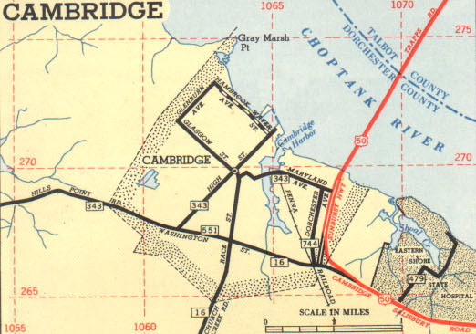 Cambridge inset, showing MD 744, 1953 SRC official map.


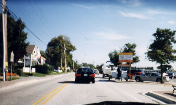 Construction notice on southbound MD 2 in Solomons Island, 1998. MD 749 marker appears there.


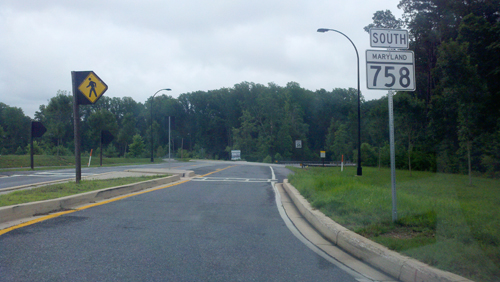 MD 758 signed at northern end, Ridge Road circle, Hanover. (Photo 07-05-13)
