|
| Routes: Interstates US Routes State Routes: | Home |
| Routes 760-779 (740-759) Prev (780-799) Next |
Quick Links: Marked Unmarked
Decommissioned |
|
Calvert
Lusby
Chesapeake Ranch Estates Rousby Hall |
MD 760
· Rousby Hall Rd
4.65 mi.; from MD 2/4 south to road end at Rousby Rd, Ship Point.
Status: Signed north-south. Route 760 came into being in two stages in 1961-62, the first piece being _south_ of Olivet Rd to the dead end, the latter connecting that with MD 2. Olivet Road, along with the part of 760 north of it, had been MD 503 prior to 1957. Route 760 south of Olivet Rd was 504. |
760
4.6 MD 2/44.4 MD 765Q 3.1 Olivet Rd 3.1 S Connector Blvd 0.0 BSM |
|
Calvert
Parran
|
MD 761
· Old Plum Point Rd
0.23 mi.; loop south off MD 261 near Plum Point Elementary School.
Status: Unsigned, associated with MD 263. This incarnation of MD 761 functions mainly as a loop separating the elementary school from mainline MD 263 traffic. |
|
|
Prince George's
Upper Marlboro
|
MD 761
· was Old Crain Hwy
3 sections; old MD 3 near Upper Marlboro.
Status: Decommissioned 1954, associated with US 301 / MD 3. Number since recycled to current 761 Consisted of three sections: from US 301 S of Swanson Road to current MD 725 (then 4) at Wells Corner, from MD 725 in Upper Marlboro S to US 301, and a section of old US 301 at Croom Road (MD 382). |
|
|
Anne Arundel
BWI Airport
|
MD 762
· Andover Rd
0.53 mi.; from MD 162 (Aviation Blvd) north to MD 170 (Telegraph Rd).
Status: Unsigned, associated with MD 162. Route 762 dates from 1988, when MD 162 was relocated westward to connect with MD 170, forming what's signed today as the Airport Loop. The remnant of 162 became 762. Andover Road was originally part of Hammonds Ferry Road, which was MD 167 up to the Anne Arundel-Baltimore County border. By 1970 MD 167 had been truncated to MD 170, and at some later point before 1980 it was decommissioned. When the portion of Hammonds Ferry Rd east of BWI was rebuilt, the name was changed to Aviation Blvd, and the number was changed to 162. |
|
|
Harford
Havre de Grace
|
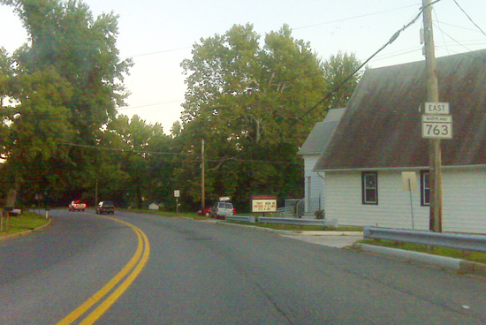
MD 763
· Superior St [Havre de Grace]
0.28 mi.; from MD 155 east to end of maintenance at Juniata St
Status: Signed east-west, associated with MD 155. Route 763 lives beneath the western end of the (US 40) Hatem Bridge, and is the remnant of MD 155 when it peels off right on Ohio Street to connect with US 40. State maintenance ends at the corner of Juniata Street, which leads southward to the center of Havre de Grace.
|
763
0.0 MD 1550.3 Juniata St |
|
Calvert
|
MD 764
· Breezy Point Rd, Old Willows Rd
2 sections; south off MD 261
Status: Unsigned, associated with MD 261. MD 764 is a short piece of Breezy Point Rd, 764A appears to be essentially a driveway, but may have been an old alignment. Sections of MD 764: |
|
|
Calvert
Prince Frederick
Port Republic St. Leonard Walnut Cove Lusby Bertha Appeal Newtown Solomons |
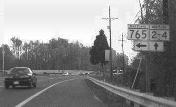
MD 765
26 sections, 6 signed
Status: Signed on mainline, minor connectors unsigned, associated with MD 2/4. All sections are still active here except for 765L. They've run through the alphabet, so the next suffix will be MD 765CA, C for Calvert. Sections of MD 765: The north-south order of signed sections is 765A, 765, 765N, 765P, 765Q, 765R.
|
765A
0.0 MD 2/40.0 MD 2/4 0.0 MD 2/4 0.0 MD 2/4
765
0.0 MD 2/40.0 MD 2/4 0.0 MD 2/4 0.0 MD 2/4
765N
0.0 MD 2/40.0 MD 2/4 0.0 MD 2/4
765P
0.0 MD 2/40.0 MD 2/4 0.0 MD 2/4
765Q
0.0 MD 2/40.0 MD 2/4 0.0 MD 2/4
765R
0.0 MD 2/40.0 MD 2/4 0.0 MD 2/4 |
|
County
Town 1
Town 2 Town 3 County
Town 1
Town 2 Town 3 |
MD 766
· Road Name Here
00.00 mi.; from ... to ...
Marked Unmarked No longer assigned (decommissioned). north-south. east-west. ................... ................... Sections of MD 760: |
766
0.00 0 MD 7600.00 0 MD 760 0.00 0 MD 760 0.00 0 MD 760 0.00 0 MD 760 0.00 0 MD 760 0.00 0 MD 760 0.00 0 MD 760 0.00 0 MD 760 |
|
County
Town 1
Town 2 Town 3 County
Town 1
Town 2 Town 3 |
MD 767
· Road Name Here
00.00 mi.; from ... to ...
Marked Unmarked No longer assigned (decommissioned). north-south. east-west. ................... ................... Sections of MD 760: |
767
0.00 0 MD 7600.00 0 MD 760 0.00 0 MD 760 0.00 0 MD 760 0.00 0 MD 760 0.00 0 MD 760 0.00 0 MD 760 0.00 0 MD 760 0.00 0 MD 760 |
|
County
Town 1
Town 2 Town 3 County
Town 1
Town 2 Town 3 |
MD 768
· Road Name Here
00.00 mi.; from ... to ...
Marked Unmarked No longer assigned (decommissioned). north-south. east-west. ................... ................... Sections of MD 760: |
768
0.00 0 MD 7600.00 0 MD 760 0.00 0 MD 760 0.00 0 MD 760 0.00 0 MD 760 0.00 0 MD 760 0.00 0 MD 760 0.00 0 MD 760 0.00 0 MD 760 |
|
County
Town 1
Town 2 Town 3 County
Town 1
Town 2 Town 3 |
MD 769
· Road Name Here
00.00 mi.; from ... to ...
Marked Unmarked No longer assigned (decommissioned). north-south. east-west. ................... ................... Sections of MD 760: |
769
0.00 0 MD 7600.00 0 MD 760 0.00 0 MD 760 0.00 0 MD 760 0.00 0 MD 760 0.00 0 MD 760 0.00 0 MD 760 0.00 0 MD 760 0.00 0 MD 760 |
|
Baltimore
Eastpoint
|
MD 770
· was Conley St
from MD 151 (North Point Blvd) west to former MD 20 (Old North Point Rd).
Status: Decommissioned 1998. Wasn't signed before that. A short connector between the old (20) and new (151) North Point Road, northwest of the 150-151 interchange. Since Old North Point Rd spills out directly onto the ramp, a left on Eastern Ave isn't possible. This connector allowed access to MD 151 and the interchange, allowing for all movements. |
|
|
County
Town 1
Town 2 Town 3 County
Town 1
Town 2 Town 3 |
MD 771
· Road Name Here
00.00 mi.; from ... to ...
Marked Unmarked No longer assigned (decommissioned). north-south. east-west. ................... ................... Sections of MD 760: |
771
0.00 0 MD 7600.00 0 MD 760 0.00 0 MD 760 0.00 0 MD 760 0.00 0 MD 760 0.00 0 MD 760 0.00 0 MD 760 0.00 0 MD 760 0.00 0 MD 760 |
|
County
Town 1
Town 2 Town 3 County
Town 1
Town 2 Town 3 |
MD 772
· Road Name Here
00.00 mi.; from ... to ...
Marked Unmarked No longer assigned (decommissioned). north-south. east-west. ................... ................... Sections of MD 760: |
772
0.00 0 MD 7600.00 0 MD 760 0.00 0 MD 760 0.00 0 MD 760 0.00 0 MD 760 0.00 0 MD 760 0.00 0 MD 760 0.00 0 MD 760 0.00 0 MD 760 |
|
County
Town 1
Town 2 Town 3 County
Town 1
Town 2 Town 3 |
MD 773
· Road Name Here
00.00 mi.; from ... to ...
Marked Unmarked No longer assigned (decommissioned). north-south. east-west. ................... ................... Sections of MD 760: |
773
0.00 0 MD 7600.00 0 MD 760 0.00 0 MD 760 0.00 0 MD 760 0.00 0 MD 760 0.00 0 MD 760 0.00 0 MD 760 0.00 0 MD 760 0.00 0 MD 760 |
|
County
Town 1
Town 2 Town 3 County
Town 1
Town 2 Town 3 |
MD 774
· Road Name Here
00.00 mi.; from ... to ...
Marked Unmarked No longer assigned (decommissioned). north-south. east-west. ................... ................... Sections of MD 760: |
774
0.00 0 MD 7600.00 0 MD 760 0.00 0 MD 760 0.00 0 MD 760 0.00 0 MD 760 0.00 0 MD 760 0.00 0 MD 760 0.00 0 MD 760 0.00 0 MD 760 |
|
County
Town 1
Town 2 Town 3 County
Town 1
Town 2 Town 3 |
MD 775
· Road Name Here
00.00 mi.; from ... to ...
Marked Unmarked No longer assigned (decommissioned). north-south. east-west. ................... ................... Sections of MD 760: |
775
0.00 0 MD 7600.00 0 MD 760 0.00 0 MD 760 0.00 0 MD 760 0.00 0 MD 760 0.00 0 MD 760 0.00 0 MD 760 0.00 0 MD 760 0.00 0 MD 760 |
|
County
Town 1
Town 2 Town 3 County
Town 1
Town 2 Town 3 |
MD 776
· Road Name Here
00.00 mi.; from ... to ...
Marked Unmarked No longer assigned (decommissioned). north-south. east-west. ................... ................... |
776
0.00 0 MD 7600.00 0 MD 760 0.00 0 MD 760 0.00 0 MD 760 0.00 0 MD 760 0.00 0 MD 760 0.00 0 MD 760 0.00 0 MD 760 0.00 0 MD 760 |
|
County
Town 1
Town 2 Town 3 County
Town 1
Town 2 Town 3 |
MD 777
· Road Name Here
00.00 mi.; from ... to ...
Marked Unmarked No longer assigned (decommissioned). north-south. east-west. ................... ................... Sections of MD 760: |
777
0.00 0 MD 7600.00 0 MD 760 0.00 0 MD 760 0.00 0 MD 760 0.00 0 MD 760 0.00 0 MD 760 0.00 0 MD 760 0.00 0 MD 760 0.00 0 MD 760 |
|
County
Town 1
Town 2 Town 3 County
Town 1
Town 2 Town 3 |
MD 778
· Road Name Here
00.00 mi.; from ... to ...
Marked Unmarked No longer assigned (decommissioned). north-south. east-west. ................... ................... Sections of MD 760: |
778
0.00 0 MD 7600.00 0 MD 760 0.00 0 MD 760 0.00 0 MD 760 0.00 0 MD 760 0.00 0 MD 760 0.00 0 MD 760 0.00 0 MD 760 0.00 0 MD 760 |
|
County
Town 1
Town 2 Town 3 County
Town 1
Town 2 Town 3 |
MD 779
· Road Name Here
00.00 mi.; from ... to ...
Marked Unmarked No longer assigned (decommissioned). north-south. east-west. ................... ................... Sections of MD 760: |
779
0.00 0 MD 7600.00 0 MD 760 0.00 0 MD 760 0.00 0 MD 760 0.00 0 MD 760 0.00 0 MD 760 0.00 0 MD 760 0.00 0 MD 760 0.00 0 MD 760 |